Hurricane Emily (1987)
| Category 3 major hurricane (SSHWS/NWS) | |
.JPG) Hurricane Emily near its peak as a Category 3 hurricane on September 22 | |
| Formed | September 20, 1987 |
|---|---|
| Dissipated | September 26, 1987 |
| Highest winds |
1-minute sustained: 125 mph (205 km/h) |
| Lowest pressure | 958 mbar (hPa); 28.29 inHg |
| Fatalities | 2 direct, 1 indirect |
| Damage | $80.3 million (1987 USD) |
| Areas affected | Lesser Antilles, Haiti, Dominican Republic, Bahamas, Bermuda |
| Part of the 1987 Atlantic hurricane season | |
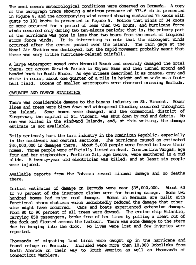
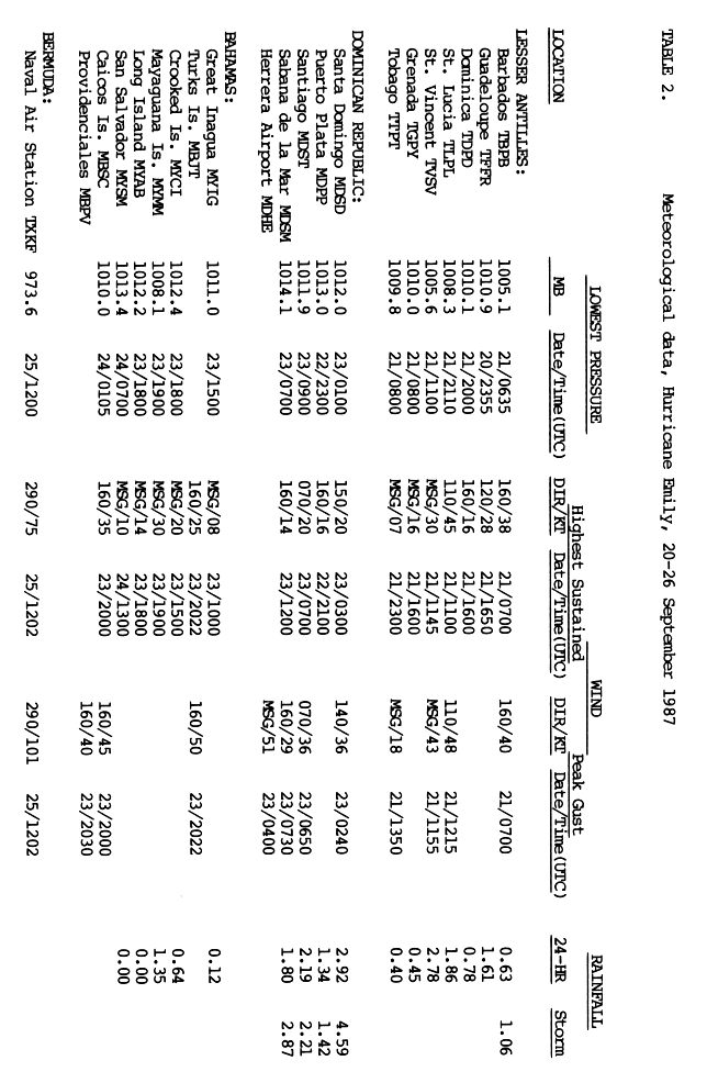
Hurricane Emily was the only major hurricane to develop during the below-average 1987 Atlantic hurricane season. Forming out of a tropical disturbance that moved off the west coast of Africa on September 20, the storm quickly attained hurricane status before undergoing rapid intensification. On September 22, the storm attained its peak intensity with winds of 125 mph (205 km/h) and a barometric pressure of 958 mbar (hPa; 28.29 inHg). The storm weakened slightly to Category 2 status before making landfall in the Dominican Republic. After weakening to a tropical storm, Emily rapidly tracked northeastward through the Atlantic Ocean, undergoing a second phase of rapid intensification before passing directly over Bermuda on September 25. The following day the final public advisory from the National Hurricane Center was issued on the storm as it transitioned into an extratropical cyclone.
Hurricane Emily brought heavy rains and strong winds in the Windward Islands on September 21, leaving numerous homes damaged and severe losses in the banana industry. Losses throughout the islands amounted to $291,000. In the Dominican Republic, despite the storm's high intensity, relatively moderate damage occurred. Three people were killed by the storm and damages amounted to $30 million. Unexpected intensification of the storm led to severe impact in Bermuda. The storm caused $50 million in damages and injured 16 people.
Meteorological history
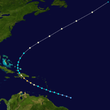
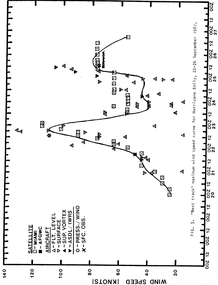
Hurricane Emily originated out of a tropical disturbance, associated with the Intertropical Convergence Zone (ITCZ), that moved off the west coast of Africa on September 13. Tracking westward at a low latitude, the system fluctuated in organization, with the development and weakening of deep convection and weak outflow for several days. By September 18, the disturbance entered a region where there was sinking air, an inhibiting factor of tropical cyclone development. Two days later, the system separated from the ITCZ and quickly developed into a tropical depression, the twelfth of the season, while located about 605 miles (975 kilometers) southeast of Barbados.[1]
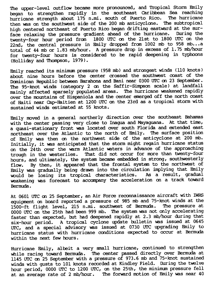
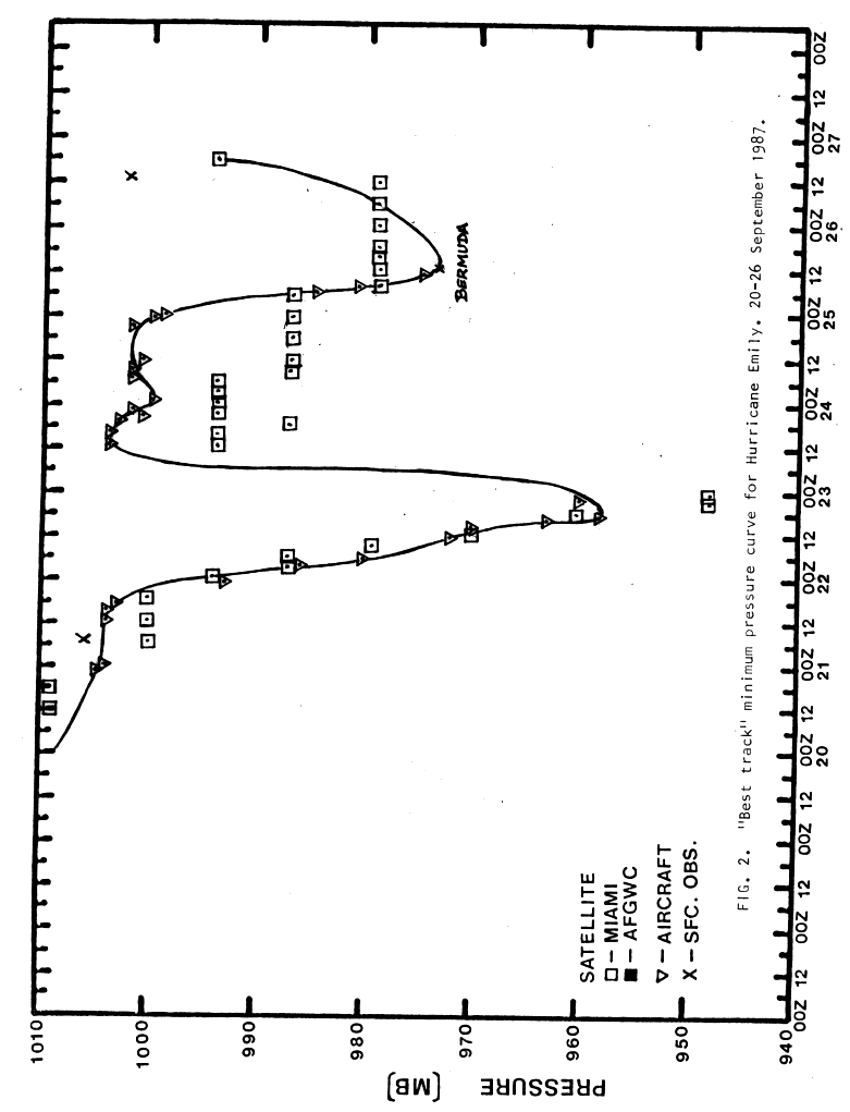
Gradual intensification took place throughout September 20, attaining the status of tropical storm by 1800 UTC and received the name Emily. The storm tracked in a general west-northwest direction around the edge of a strong subtropical ridge. By 1200 UTC on September 21, the center of Emily passed directly over St. Vincent with winds of 50 mph (85 km/h).[1] Situated underneath an anticyclone, rapid intensification took place as the storm quickly tracked towards Hispaniola. In the 24-hour span between 1800 UTC on September 21 and 1800 UTC on September 22, the central barometric pressure of the storm dropped 44 mbar (hPa) to 958 mbar (hPa; 28.29 inHg) and winds increased to 125 mph (205 km/h), equivalent to a high-end Category 3 hurricane on the Saffir–Simpson Hurricane Scale.[2] At the time of peak intensity, the hurricane hunters recorded flight-level winds of 155 mph (250 km/h) and unofficial pressure of 949 mbar (hPa; 28.02 inHg).[3][4]

Slight weakening took place late on September 22 and early on September 23 as the hurricane neared landfall. Around 0300 UTC, the eye of Emily tracked onshore between Barahona and Bani, Dominican Republic as a strong Category 2 hurricane with winds of 110 mph (175 km/h). Within 12 hours of landfall, the hurricane weakened to a tropical storm and had emerged into the Atlantic Ocean near Haiti with winds of 65 mph (100 km/h). The storm significantly slowed while tracking through the eastern Bahamas as a quasi-stationary frontal system influenced Emily. Moving generally towards the north, the center of circulation passed very close to Inagua and Mayaguana on September 24.[2]
By midday on September 24, the system became embedded within the mid-latitude westerlies and rapidly accelerated towards the northeast. The National Hurricane Center anticipated that Emily would undergo an extratropical transition within 24 hours at this point as they forecast it to merge with the frontal system to the northeast. However, the storm unexpectedly underwent a second phase of rapid intensification on September 25, at one point reaching the rate of explosive intensification with the central pressure decreasing at 2.5 mbar per hour. By 0600 UTC, Emily had re-attained hurricane intensity and at 1145 UTC, the center passed directly over Bermuda with winds of 85 mph (140 km/h). Soon after, the storm reached its secondary peak intensity with winds of 90 mph (150 km/h) and a minimum pressure of 974 mbar (hPa; 28.76 inHg).[2]
Hurricane Emily continued tracking northeast throughout September 25 into the following day with increasing speed. By late on September 25, the forward motion of the storm had reached 50 mph (85 km/h). The storm now began to undergo an extratropical transition with forward speed peaking at 65 mph (100 km/h), the third highest forward motion ever recorded in a tropical cyclone. Interacting with a baroclinic zone, the hurricane completed its transition at 1800 UTC on September 26, resulting in the issuance of the final advisory on the storm.[5]
Preparations
_near_Bermuda.JPG)
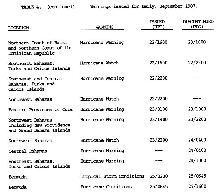
As Tropical Storm Emily quickly approached the Windward Islands on September 21, a tropical storm warning was issued for Grenada, Barbados, St. Vincent and St. Lucia. A tropical storm watch was also declared for Martinique.[6] As the storm tracked through the islands,[1] all watches and warnings were discontinued later that day.[6] Early on September 22, a hurricane warning was issued for the southern coast of the Dominican Republic and southern Haiti, including the southwestern peninsula.[6] Upon attaining major hurricane status, a hurricane warning was declared for northern Haiti as the storm was anticipated to maintain hurricane intensity through landfall. Later that day, a hurricane watch was issued for the southeastern Bahamas and the Turks and Caicos Islands. This watch was later upgraded to a warning as the storm was expected to regain intensity over the Bahamas.[7]
Following the anticipation of a more westerly track on September 23,[2] a hurricane watch was issued for the northwestern Bahamas, later superseded by a warning, and a hurricane warning was declared for eastern Cuba. Early on September 24, all watches and warnings for the Caribbean Islands, including the Bahamas, were discontinued as Emily moved out over the Atlantic Ocean.[2][7] On September 25, a special advisory was issued for Bermuda as tropical storm-force winds were likely to impact the island.[7] Following the unexpected intensification,[2] another special advisory was issued stating that hurricane-force winds would impact the island during the day on September 25. This advisory was discontinued following the storms' passage later that day.[7]
Throughout the Windward Islands, schools and businesses were closed ahead of the storm.[8] In the Dominican Republic, roughly 6,000 people were evacuated from Santo Domingo ahead of the storm.[9] Although the storm never tracked towards Florida, state officials advised residents to prepare for the storm.[10] Officials were in the "awareness stage" of hurricane preparation as they were discussing the possibility of impact from Emily.[11] In the Turks and Caicos, residents were evacuated from low-lying areas to shelters throughout the islands.[12]
On September 25, the Canadian Hurricane Centre issued its first information bulletin ever related to a tropical cyclone as Emily was moving into Canadian offshore waters. The agency was created less than a month earlier, and warned for the potential of heavy rainfall and strong winds in the ocean southeast of Newfoundland.[13][14]
Impact and aftermath

Tracking through the Lesser Antilles as a tropical storm, Emily brought heavy rains to several islands. In Barbados, high winds caused widespread roof damage and downed trees and power lines; losses on the island reached $100,000.[8][15] On St. Vincent, the banana industry sustained severe losses, with roughly 70% of the crop destroyed.[15][16] Schools throughout the island were closed prior and during the storm.[17] Up to of 3 in (76 mm) of rain fell within six hours on the island,[15] causing flooding that forced eight families to evacuate their homes.[8] Damage on the island amounted to $191,000, mainly from landslides.[18] The outer bands of Emily produced moderate rainfall across portions of southwest Puerto Rico, peaking at 4.63 in (118 mm).[19]
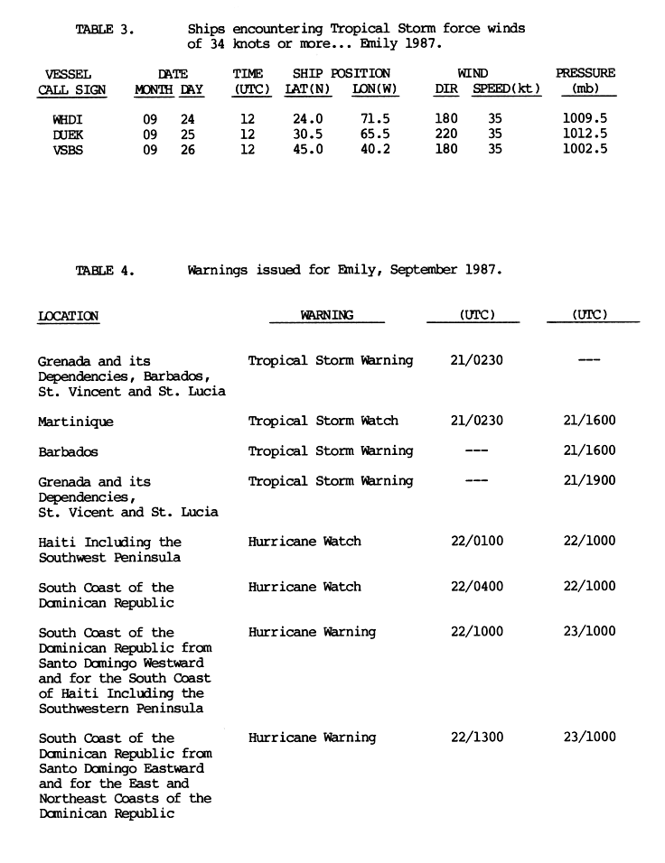
In the Dominican Republic, Emily's heavy rains caused widespread mudslides, killing two people.[15] Another person was killed after stepping on a downed power line.[20] An estimated 5,000 people were left homeless in the aftermath of the storm.[21] Upwards of 4.59 in (117 mm) of rain fell during the storm in the Dominican Republic.[22] The farming industry was impacted particularly hard, with $30 million in losses occurring.[21] Following the storm, hundreds of volunteers in the Dominican Republic assisted evacuees in shelters and helped officials clean up the affected areas. The Red Cross was also deployed to the region to assist those left homeless by the storm.[20] In all, Emily caused $80.3 million in damage and killed three people.[15][21]
Although Emily passed over Haiti, it produced little damage and no loss of life. The lack of fatalities was linked to the amount of forest remaining over the mountains of the country, estimated at 25% of their original size, compared to the 1.4% remaining in 2004.[23] In the Bahamas, Emily produced winds up to 60 mph (95 km/h) along with rainfall up to 1.35 in (34 mm).[22]
Since the storm was not expected to be strong when it passed Bermuda, islanders were caught off guard by the 90 mph (150 km/h) winds. Cars and boats were affected the most, though some houses experienced severe damage during the storm's passage as well. Hurricane Emily caused $50 million in damage to the island, though no one was killed. About 230 buildings lost their roofs and 16 people were injured due to winds gusting in excess of 112 mph (180 km/h). The local airport was shut down as a large portion of its roof was blown off during the storm. Several cars and boats were flipped by the storm and a cruise ship carrying 700 people slipped from its moorings.[24][25] Before the storm's landfall, officials in Bermuda cut power to roughly 90% of the island to protect the power grid.[26] There were also unconfirmed reports of tornadoes associated with the storm. Emily was the strongest hurricane to hit Bermuda since the 1948 season.[15]
See also
References
- 1 2 3 Harold P. Gerrish (November 12, 1987). "Hurricane Emily Preliminary Report: Page One". National Hurricane Center. Retrieved July 2, 2009.
- 1 2 3 4 5 6 Harold P. Gerrish (November 12, 1987). "Hurricane Emily Preliminary Report: Page Two". National Hurricane Center. Retrieved July 2, 2009.
- ↑ Harold P. Gerrish (November 12, 1987). "Hurricane Emily Preliminary Report: Page Nineteen". National Hurricane Center. Retrieved July 3, 2009.
- ↑ Harold P. Gerrish (November 12, 1987). "Hurricane Emily Preliminary Report: Page Twenty". National Hurricane Center. Retrieved July 3, 2009.
- ↑ Harold P. Gerrish (November 12, 1987). "Hurricane Emily Preliminary Report: Page Three". National Hurricane Center. Retrieved July 2, 2009.
- 1 2 3 Harold P. Gerrish (November 12, 1987). "Hurricane Emily Preliminary Report: Page Nine". National Hurricane Center. Retrieved July 3, 2009.
- 1 2 3 4 Harold P. Gerrish (November 12, 1987). "Hurricane Emily Preliminary Report: Page Ten". National Hurricane Center. Retrieved July 3, 2009.
- 1 2 3 "Hurricane Emily strengthening". The Free-Lance Star. Associated Press. September 22, 1987. Retrieved July 3, 2009.
- ↑ "Hurricane Emily kills 3 in Caribbean". Pittsburgh Post-Gazette. Associated Press. September 24, 1987. Retrieved July 3, 2009.
- ↑ Staff Writer (September 23, 1987). "County yawns at Hurricane Emily; Officials prepare for possible disaster". Miami Herald. Retrieved July 3, 2009.
- ↑ Staff Writer (September 23, 1987). "Emily brings hurricanes to mind". Miami Herald. Retrieved July 3, 2009.
- ↑ A. J. Dickerson (September 24, 1987). "Hurricane warning lifted as Emily weakens". The Free-Lance Star. Retrieved July 3, 2009.
- ↑ Canadian Hurricane Centre (2009-07-15). History of the Canadian Hurricane Centre (CHC) (Report). Environment Canada. Retrieved 2013-08-08.
- ↑ RWH (September 25, 1987). Canadian Hurricane Prognostic Message Issued By Environment Canada at 0830 PM ADT Friday 25 September 1987 (TXT) (Report). Canadian Hurricane Centre. Retrieved August 8, 2013.
- 1 2 3 4 5 6 Robert A. Case and Harold P. Gerrish (April 1988). "Atlantic Hurricane Season of 1987" (PDF). National Hurricane Center. Retrieved July 1, 2009.
- ↑ Department of Public Affairs (November 1994). "St. Vincent and the Grenadines". United States Department of State. Retrieved July 1, 2009.
- ↑ "Hurricane Emily Strengthens, Posing Threat to Hispaniola". The New York Times. Associated Press. September 22, 1987. Retrieved July 1, 2009.
- ↑ Nicholas DeGraff (August 25, 1999). "Natural Hazards and Disasters: Landslides in St. Lucia". University of California, Santa Cruz. Retrieved July 1, 2009.
- ↑ David M. Roth (2009). "Hurricane Emily - September 21–23, 1987". Hydrometeorological Prediction Center. Retrieved July 2, 2009.
- 1 2 "Emily regaining strength after hitting Dominican". The Bulletin. United Press International. September 23, 1987. Retrieved July 3, 2009.
- 1 2 3 Harold P. Gerrish (November 12, 1987). "Hurricane Emily Preliminary Report: Page 4". National Hurricane Center. Retrieved July 1, 2009.
- 1 2 Harold P. Gerrish (November 12, 1987). "Hurricane Emily Preliminary Report: Page Eight". National Hurricane Center. Retrieved July 2, 2009.
- ↑ Jane Deren (2008). "Hurricanes and Haiti: A Tragic History" (PDF). Saint Bridget Church. Retrieved July 1, 2009.
- ↑ "Hurricane in Bermuda Causes Minor Injuries". The New York Times. Associated Press. September 26, 1987.
- ↑ Staff Writer (September 26, 1987). "Hurricane Emily Buffets Bermuda". The Washington Post. Retrieved July 1, 2009.
- ↑ "Hurricane injures 16 in Bermuda". The Boston Globe. Associated Press. September 26, 1987. Retrieved July 1, 2009.
External links
| Wikimedia Commons has media related to Hurricane Emily (1987). |
- The National Hurricane Center's Preliminary Report on Hurricane Emily
- Monthly Weather Summary for 1987
- Photo gallery of Bermuda damage from The Royal Gazette
Tropical cyclones of the 1987 Atlantic hurricane season | ||
|---|---|---|
 | ||
| ||