Hurricane Bertha (2014)
| Category 1 hurricane (SSHWS/NWS) | |
 Hurricane Bertha northeast of The Bahamas on August 4 | |
| Formed | August 1, 2014 |
|---|---|
| Dissipated | August 16, 2014 |
| (Extratropical after August 6) | |
| Highest winds |
1-minute sustained: 80 mph (130 km/h) |
| Lowest pressure | 998 mbar (hPa); 29.47 inHg |
| Fatalities | 3 direct, 1 indirect |
| Areas affected | |
| Part of the 2014 Atlantic hurricane season | |
Hurricane Bertha was an unusual tropical cyclone in early August 2014 that attained minimal hurricane status, despite having a disheveled appearance and a relatively high atmospheric pressure. On July 26, a tropical wave south of the Cape Verde Islands was monitored for possible tropical cyclogenesis. Over the following days, it slowly developed and acquired gale-force winds and enough convection to be designated as Tropical Storm Bertha early on August 1. A mostly disorganized cyclone, Bertha quickly moved across the Lesser Antilles, clipping the northern end of Martinique, later that day. During its trek across the eastern Caribbean Sea, its circulation became severely disrupted and it may have degenerated into a tropical wave. On August 3, it traversed the Mona Passage and moved over the Southeastern Bahamas where conditions favored development. Despite an overall ragged appearance on satellite imagery, data from Hurricane Hunters indicated it intensified to a hurricane on August 4; it acquired peak winds of 80 mph (130 km/h) that day. Turning north, and later northeast, Bertha soon weakened as it began to merge with an approaching trough to the west. This merger ultimately took place on August 6, at which time Bertha was declared extratropical well to the south of Nova Scotia. The remnant system raced eastward across the Atlantic and later struck the United Kingdom on August 10. Once over the North Sea, the storm stalled for a few days before resuming its eastward track. It was last noted around the Baltic Sea on August 16.
As a tropical cyclone, Bertha's impact was relatively minor. Widespread power outages occurred along its path but no major damage or loss of life took place. Enhanced swells and rip currents associated with the hurricane resulted in three fatalities and dozens of rescues along the East Coast of the United States. After becoming an extratropical system, it had significant effects in Western Europe. Particularly hard hit was the United Kingdom, where wind gusts reached 108 mph (174 km/h). Unseasonably heavy rains triggered widespread flooding which shut down roads and prompted evacuations. One fatality took place offshore. On mainland Europe, a small tornado outbreak resulted in scattered structural damage in Belgium, France, and Germany.
Meteorological history

On July 24, 2014, a westward moving tropical wave emerged off the west coast of Africa near the Cape Verde Islands. Following the development of convective activity —showers and thunderstorms— on July 26, National Hurricane Center (NHC) began monitoring the system for potential tropical cyclogenesis.[1][2] A disorganized system, development was forecast to be slow due to unfavorable environmental conditions.[3] Organization and coverage of convection began improving by July 28, due in part to the passage of a Kelvin wave.[1][4] An area of low pressure subsequently consolidated within the disturbance on July 29 and the NHC assessed the system as having imminent potential of becoming a tropical depression.[5] Convection soon diminished over the system, though its circulation remained well-defined.[6] Moving west-northwest around the periphery of a strong subtropical ridge,[7] the low acquired tropical storm-force winds early on July 31 but continued to lack convection.[8] A hurricane hunter aircraft investigated the system that afternoon and found winds of 45 mph (75 km/h) north and northeast of the center. In the hours following the weather reconnaissance mission, a band of deep convection blossomed near the center, prompting the NHC to designate the system as Tropical Storm Bertha at 00:00 UTC on August 1. Upon its classification, Bertha was situated roughly 345 mi (555 km) east-southeast of Barbados in the Lesser Antilles.[1][7]
Within hours of Bertha's designation on August 1, wind shear stemming from a trough over the central Atlantic displaced convection from the circulation center.[1][9] Satellite imagery depicted a well-defined and vigorous circulation; however, observations from the hurricane hunters indicated a wind field more akin to a tropical wave.[10] Around 21:00 UTC, Bertha clipped the northern end of Martinique with sustained winds of 50 mph (85 km/h).[11] Persistent shear continued to take its toll on the cyclone as it entered the Caribbean Sea with aircraft data indicating no closed circulation at 5,000 ft (1,500 m) elevation. Despite this, observations from Martinique and Dominica indicated that there was some semblance of a surface circulation, and the NHC continued to monitor Bertha as a tropical storm.[12] Throughout August 2, convection steadily increased in coverage and organization though the center of Bertha remained displaced from the strongest thunderstorms to the southwest. NEXRAD weather radar imagery from San Juan, Puerto Rico depicted a disorganized, possibly open circulation throughout the day. In light of this, NHC forecaster John Beven noted that the system could degenerate into an open wave around the time in reached Hispaniola later on August 2.[13]

Continued effects of dry air entrainment, shear, and land interaction further degraded Bertha's structure and late on August 2, "the system barely [qualified] as a tropical cyclone".[14] Various data sources indicated no closed circulation by 21:00 UTC and it was noted that advisories could be discontinued, at least temporarily.[14] Early on August 3, the disheveled storm moved through the Mona Passage and brushed the eastern coast of the Dominican Republic before emerging over the Atlantic Ocean.[15] As the storm moved away from Hispaniola its movement became more northwesterly, following the edge of the subtropical ridge.[16] Moving near the Turks and Caicos Islands,[17] Bertha's circulation finally became better organized and banding features developing over its eastern periphery.[18] Subsequent strengthening of upper-level outflow, decreased shear, increased mid-level humidity, and high sea surface temperatures enabled rapid intensification.[1] Deep convection wrapped cyclonically into the storm and winds reached 65 mph (100 km/h) by 03:00 UTC on August 4.[19][20] During the early part of August 4, structural organization began to degrade with convection becoming more limited in extent and banding features dissipating. The only factor aiding the storm was its well-defined outflow. However, despite the storm's ragged and weak appearance observations from hurricane hunters indicated that it had intensified into a hurricane by 12:00 UTC.[1][21] Bertha is estimated to have reached its peak intensity around this time with winds of 80 mph (130 km/h) and a barometric pressure of 998 mbar (hPa; 29.47 inHg).[1] Additionally, by this time its movement had shifted to due north and with increased forward momentum.[21][22]
Through the remainder of August 4 and into the early hours of August 5, Bertha maintained hurricane status with its atypical structure. At times, its circulation became exposed due to increasing shear.[23] Acceleration to the north-northeast ahead of a trough off the East Coast of the United States ensued as the system weakened below hurricane intensity during the overnight of August 4–5.[24] Steadily increasing shear kept the circulation center mostly devoid of thunderstorms, with periodic bursts of convection being quickly pushed away. The storm's motion became more northeasterly early on August 6 as it began to undergo an extratropical transition.[25] An upper-level jet streak coupled with the system that morning, prompting convection to develop away from the storm's center.[26] Bertha soon merged with the trough steering it northeast as it moved into the cold sector of the front, which extended from Nova Scotia to The Bahamas. The merger of these systems marked Bertha's transition into an extratropical system,[27] at which time it was located 290 mi (470 km) south-southeast of Halifax, Nova Scotia.[1] Slight intensification took place shortly thereafter with winds increasing to 60 mph (95 km/h) before weakening resumed. The system raced eastward across the Atlantic and ultimately degraded into a trough several hundred miles southwest of Ireland on August 9.[1] Bertha's remnants struck the United Kingdom the following day and later moved over the North Sea.[28] There, the storm stalled for a few days before resuming its eastward track.[29] The decaying cyclone moved over Scandinavia on August 14 and was last noted on August 16 near the Baltic Sea.[30][31][32]
Warnings and watches
| Date | Time issued | Warning type | Areas/changes to previous |
|---|---|---|---|
| August 1 | 03:00 UTC | Tropical Storm Warning | Barbados, Dominica, and St. Lucia |
| Tropical Storm Watch | Culebra, Puerto Rico, Saint Vincent and the Grenadines, the United States Virgin Islands, and Vieques | ||
| 06:00 UTC | Tropical Storm Watch | British Virgin Islands | |
| 09:00 UTC | Tropical Storm Warning | The British Virgin Islands, Culebra, Puerto Rico, the United States Virgin Islands, and Vieques | |
| 12:00 UTC | Tropical Storm Warning | Martinique | |
| 15:00 UTC | Tropical Storm Watch | Eastern Dominican Republic between Cabo Frances Viejo and Saona Island | |
| Advisories discontinued | Barbados, Saint Vincent and the Grenadines | ||
| 18:00 UTC | Advisories discontinued | St. Lucia | |
| 21:00 UTC | Tropical Storm Watch | Southern Bahamas, including the Acklins, Crooked Island, Long Cay, Inagua, Mayaguana, Ragged Island, and the Turks and Caicos | |
| August 2 | 03:00 UTC | Advisories discontinued | Dominica |
| 09:00 UTC | Tropical Storm Warning | Southern Bahamas, including the Acklins, Crooked Island, Long Cay, Inagua, Mayaguana, Ragged Island, and the Turks and Caicos | |
| Tropical Storm Watch | Central Bahamas, including Cat Island, Exumas, Long Island, Rum Cay, and San Salvador | ||
| 15:00 UTC | Tropical Storm Warning | Eastern Dominican Republic between Cabo Frances Viejo and Saona Island | |
| Advisories discontinued | Martinique | ||
| 21:00 UTC | Advisories discontinued | The British Virgin Islands and the United States Virgin Islands | |
| August 3 | 00:00 UTC | Advisories discontinued | Culebra, Puerto Rico, and Vieques |
| 12:00 UTC | Advisories discontinued | Eastern Dominican Republic | |
| 15:00 UTC | Advisories discontinued | Central Bahamas, including Cat Island, Exumas, Long Island, Rum Cay, and San Salvador | |
| 21:00 UTC | Advisories discontinued | Southern Bahamas, including the Acklins, Crooked Island, Long Cay, Inagua, Mayaguana, Ragged Island, and the Turks and Caicos |
Preparations and impact
Caribbean
Late on August 1, Bertha crossed the Lesser Antilles, bringing strong winds and heavy rain to many islands. Across Martinique, the storm produced sustained winds of 46 mph (74 km/h) with gusts to 54 mph (87 km/h).[1] Numerous lightning strikes caused widespread surges in the electrical grid and left 150,000 residences without electricity. Power was restored to all customers by the evening of August 2.[33][34] Rainfall was relatively light and less than anticipated with 1.2 to 2.4 in (30 to 60 mm) falling across northern areas of the island and 0.39 to 0.79 in (10 to 20 mm) over southern areas.[35] Similar effects were felt in Guadeloupe where gusts reached 57 mph (92 km/h) on La Désirade. A general 3.9 to 5.9 in (100 to 150 mm) fell across Basse-Terre Island. Few reports of downed trees and power lines were received and overall damage was negligible.[36] Some rain and wind also affected Barbados.[37]
Dominica Prime Minister Roosevelt Skerrit declared a public holiday for the afternoon of August 1 in order for all workers to return home in advance of the storm.[38] Several LIAT flights for the island and St. Lucia were canceled.[37] Wind gusts on Dominica reached 43 mph (69 km/h) and hundreds of people lost power.[1][33]
Coincidentally, Bertha threatened the United States Virgin Islands 18 years after a hurricane in 1996 of the same name, with both affecting the primary elections.[39] Turnout was low as expected due to the storm, with 9,217 people (26.05 percent) of voters showing up to polls.[40] In response to the storm, the Virgin Islands Territorial Emergency Management Agency was activated, leave for all police officers was suspended, and officers began operating on 12‑hour shifts on August 1. The Public Works Department appropriated sandbags and cleared storm drains in anticipation of heavy rain.[39] The outer edges of Bertha produced near-hurricane-force around the United States Virgin Islands, with an offshore buoy near St. Thomas measuring a gust of 72 mph (116 km/h). Gale-force winds on St. Croix snapped many tree limbs.[33]
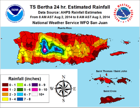
Across Puerto Rico, the outer bands of Bertha dropped a general 3 to 5 in (76 to 127 mm) of rain,[33] with isolated areas reaching 10 in (250 mm), over areas suffering from a drought.[41] Accumulations peaked at 11.11 in (282 mm) in Adjuntas.[1] Some flooding occurred on the island, resulting in the partial collapse of two roads.[41] The Río Grande de Arecibo topped its banks between highways 10 and 123 within the Utuado Municipality.[42] Landslides blocked a few roads around Aceitunas.[43] Tropical storm-force wind gusts, peaking at 52 mph (84 km/h),[1] downed some trees and power lines.[44][45] Prolific lightning accompanied the storm and resulted in 29,000 residences losing power.[33] In Arroyo, 239 people, mostly athletes, sought refuge in public shelters.[46]
Following the designation of Tropical Storm Bertha on August 1, the Ministry of Public Works and Communications in the Dominican Republic activated emergency operations to prepare for the storm.[47] Several flights to and from Las Américas International Airport near Santo Domingo were canceled on August 2.[48] Heavy rains in the country, peaking at 4.7 in (120 mm) in Bayaguana,[1] caused significant flooding, especially along the Soco River which overflowed its banks. The communities of Atilano, Cabeza de Toro, Campiña, Concho Primo, and Lima, were temporarily isolated by the rising waters. Less substantial flooding occurred elsewhere in the country, with seven homes inundated in Moscú. Additionally, strong winds downed many trees in the region.[49]
Across the Southeastern Bahamas, residents were warned of the approaching storm; however, many were preoccupied with a local regatta and ignored warnings.[33] In the Turks and Caicos, locals brought their boats closer to shore and anchored them. Hotels were reportedly "taking seriously the threat of the storm."[50] Increased surf and sporadic heavy rains associated with Bertha affected portions of Cuba.[51]
United States East Coast

Though Bertha remained hundreds of miles offshore, long-period swells resulted in dangerous rip currents across the East Coast of the United States.[52] Two people required rescue off the coast of Jacksonville, Florida due to rip currents.[53] Lingering swells resulted in the drowning of a man at Mickler's Landing in Ponte Vedra Beach.[54] Further north near Cape Hatteras, North Carolina, a man was pulled out to sea by rip currents and rescued by the Hatteras Island Rescue Squad; however, after being hospitalized he later succumbed to his injuries and died.[55] Tropical storm warnings were raised for offshore zones; waves of 15 to 25 ft (4.6 to 7.6 m) were forecast for areas off the Delmarva Peninsula and New Jersey.[56] Several people were injured in rough seas at Rehoboth Beach, Delaware while lifeguards performed multiple rescues.[57] In Ocean City, New Jersey, 25 rescues took place on August 5.[58] That same day, a woman nearly drowned near Atlantic City after being pulled out by rip currents.[59]
Western Europe

Heavy rains from the remnant of Bertha caused widespread flooding across the United Kingdom.[60] Flood warnings were issued for 6 regions across the nation while alerts were raised for a further 47 areas during the storm's passage.[61] In London, a water main burst and inundated surrounding streets. Thirty shops were affected and nearby stations of the London Underground were swamped.[60] The Prudential RideLondon race was shortened by 14 mi (23 km) due to the storm.[60] The River Dee rose to its highest level since 1990 and flooded surrounding areas. Footbridges and paths along its banks were washed away, though no structures were affected.[62] Lossiemouth, Scotland, received a month's worth of rain in roughly 12 hours. Flooding in Elgin prompted the evacuation of 200 homes. Numerous roads were washed out across Scotland and First ScotRail reported widespread service disruption.[63] High winds and flooding also damaged crops across the region, namely in Scotland.[64]
Offshore, a man suffered a fatal head injury on his yacht amid rough seas and high winds. The Solent Coastguards flew out to rescue the man, but he was declared dead on the scene.[65] Twenty vessels competing in the 2014 EXE Sails GP14 World Championships were caught in high winds produced by the storm and capsized in the Strangford Lough. A nearby hospital declared a major incident and the coast guard rushed to rescue the 97 sailors stranded in the water. Only one person suffered injuries, but all were treated for hypothermia.[66]
The outer bands of Bertha's remnants produced a prolonged period of severe weather over mainland Europe, extending from France to Sweden.[67] In southwest Germany, gusts reached 75 mph (120 km/h).[68] On August 10, a small tornado outbreak occurred with touchdowns taking place in Belgium, France, and Germany. The strongest of these, rated F2 on the Fujita Scale, affected Bad Schwalbach, Germany; 50 homes were damaged in the area and a swath of forest was heavily damaged. An F1 tornado struck an outdoor event in Luxembourg, Belgium, resulting in four serious injuries. Additionally, an EF1 storm traveled for 25 mi (41 km) through the Nord-Pas-de-Calais region of France. Another tornado, rated F0, touched down in Kingston upon Hull, United Kingdom, on the same day.[67][69]
Alerts were raised across Norway for the potential of flooding and damaging winds.[70]
See also
- 2014 Atlantic hurricane season
- Timeline of the 2014 Atlantic hurricane season
- Hurricane Danny (2003) – A hurricane with a similarly high central pressure
- Tropical cyclone effects in Europe
- Hurricane Katia – A strong hurricane whose extratropical remnants had significant impact in the British Isles
References
- 1 2 3 4 5 6 7 8 9 10 11 12 13 14 15 Eric S. Blake (December 18, 2014). Tropical Cyclone Report: Hurricane Bertha (PDF). National Hurricane Center (Report). Miami, Florida: National Oceanic and Atmospheric Administration. Retrieved December 21, 2014.
- ↑ Stacy R. Stewart (July 26, 2014). Tropical Weather Outlook (.TXT). National Hurricane Center (Report). Miami, Florida: National Oceanic and Atmospheric Administration. Retrieved August 10, 2014.
- ↑ Stacy R. Stewart (July 27, 2014). Tropical Weather Outlook (.TXT). National Hurricane Center (Report). Miami, Florida: National Oceanic and Atmospheric Administration. Retrieved August 10, 2014.
- ↑ Stacy R. Stewart (July 28, 2014). Tropical Weather Outlook (.TXT). National Hurricane Center (Report). Miami, Florida: National Oceanic and Atmospheric Administration. Retrieved August 10, 2014.
- ↑ John Cangialosi (July 29, 2014). Tropical Weather Outlook (.TXT). National Hurricane Center (Report). Miami, Florida: National Oceanic and Atmospheric Administration. Retrieved August 10, 2014.
- ↑ Richard J. Pasch (July 29, 2014). Tropical Weather Outlook (.TXT). National Hurricane Center (Report). Miami, Florida: National Oceanic and Atmospheric Administration. Retrieved August 10, 2014.
- 1 2 Stacy R. Stewart (July 31, 2014). Tropical Storm Bertha Discussion Number 1. National Hurricane Center (Report). Miami, Florida: National Oceanic and Atmospheric Administration. Retrieved August 10, 2014.
- ↑ John Cangialosi (July 31, 2014). Tropical Weather Outlook (.TXT). National Hurricane Center (Report). Miami, Florida: National Oceanic and Atmospheric Administration. Retrieved August 10, 2014.
- ↑ Lixion A. Avila (August 1, 2014). Tropical Storm Bertha Discussion Number 2. National Hurricane Center (Report). Miami, Florida: National Oceanic and Atmospheric Administration. Retrieved August 12, 2014.
- ↑ John L. Beven II (August 1, 2014). Tropical Storm Bertha Discussion Number 3. National Hurricane Center (Report). Miami, Florida: National Oceanic and Atmospheric Administration. Retrieved August 12, 2014.
- ↑ John L. Beven II (August 1, 2014). Tropical Storm Bertha Public Advisory Number 4. National Hurricane Center (Report). Miami, Florida: National Oceanic and Atmospheric Administration. Retrieved August 10, 2014.
- ↑ Michael J. Brennan (August 1, 2014). Tropical Storm Bertha Discussion Number 5. National Hurricane Center (Report). Miami, Florida: National Oceanic and Atmospheric Administration. Retrieved August 12, 2014.
- ↑ John L. Beven (August 2, 2014). Tropical Storm Bertha Discussion Number 7. National Hurricane Center (Report). Miami, Florida: National Oceanic and Atmospheric Administration. Retrieved August 12, 2014.
- 1 2 John L. Beven (August 2, 2014). Tropical Storm Bertha Discussion Number 8. National Hurricane Center (Report). Miami, Florida: National Oceanic and Atmospheric Administration. Retrieved August 12, 2014.
- ↑ Michael J. Brennan (August 2, 2014). Tropical Storm Bertha Public Advisory Number 8A. National Hurricane Center (Report). Miami, Florida: National Oceanic and Atmospheric Administration. Retrieved August 10, 2014.
- ↑ Stacy R. Stewart (August 3, 2014). Tropical Storm Bertha Discussion Number 10. National Hurricane Center (Report). Miami, Florida: National Oceanic and Atmospheric Administration. Retrieved August 12, 2014.
- ↑ Richard J. Pasch (August 2, 2014). Tropical Storm Bertha Public Advisory Number 10A. National Hurricane Center (Report). Miami, Florida: National Oceanic and Atmospheric Administration. Retrieved August 10, 2014.
- ↑ Richard J. Pasch (August 3, 2014). Tropical Storm Bertha Discussion Number 11. National Hurricane Center (Report). Miami, Florida: National Oceanic and Atmospheric Administration. Retrieved August 12, 2014.
- ↑ Richard J. Pasch (August 3, 2014). Tropical Storm Bertha Discussion Number 12. National Hurricane Center (Report). Miami, Florida: National Oceanic and Atmospheric Administration. Retrieved August 12, 2014.
- ↑ Daniel P. Brown (August 4, 2014). Tropical Storm Bertha Discussion Number 13. National Hurricane Center (Report). Miami, Florida: National Oceanic and Atmospheric Administration. Retrieved August 12, 2014.
- 1 2 Richard J. Pasch (August 4, 2014). Hurricane Bertha Discussion Number 15. National Hurricane Center (Report). Miami, Florida: National Oceanic and Atmospheric Administration. Retrieved August 12, 2014.
- ↑ Richard J. Pasch (August 4, 2014). Hurricane Bertha Public Advisory Number 15. National Hurricane Center (Report). Miami, Florida: National Oceanic and Atmospheric Administration. Retrieved August 12, 2014.
- ↑ Daniel P. Brown (August 4, 2014). Hurricane Bertha Discussion Number 17. National Hurricane Center (Report). Miami, Florida: National Oceanic and Atmospheric Administration. Retrieved August 12, 2014.
- ↑ Stacy R. Stewart (August 4, 2014). Tropical Storm Bertha Discussion Number 18. National Hurricane Center (Report). Miami, Florida: National Oceanic and Atmospheric Administration. Retrieved August 12, 2014.
- ↑ Daniel P. Brown (August 5, 2014). Tropical Storm Bertha Discussion Number 21. National Hurricane Center (Report). Miami, Florida: National Oceanic and Atmospheric Administration. Retrieved August 12, 2014.
- ↑ Michael J. Brennan (August 6, 2014). Tropical Storm Bertha Discussion Number 22. National Hurricane Center (Report). Miami, Florida: National Oceanic and Atmospheric Administration. Retrieved August 12, 2014.
- ↑ Lixion A. Avila (August 6, 2014). Post-Tropical Cyclone Bertha Discussion Number 23. National Hurricane Center (Report). Miami, Florida: National Oceanic and Atmospheric Administration. Retrieved August 12, 2014.
- ↑ "Surge Update: Many areas continue to be affected by ex-Hurricane Bertha" (PDF). GAB Robins. August 11, 2014. Retrieved December 21, 2014.
- ↑ Miranda Prynne (August 15, 2014). "UK weather: Wrap up, big chill on the way in Bertha's wake". The Telegraph. Retrieved August 15, 2014.
- ↑ "August 14, 2014 Europe Surface Analysis" (GIF). Berlin, Germany: Institut für Meteorologie. August 14, 2014. Retrieved December 21, 2014.
- ↑ "August 16, 2014 Europe Surface Analysis" (GIF). Berlin, Germany: Institut für Meteorologie. August 16, 2014. Retrieved December 21, 2014.
- ↑ "August 17, 2014 Europe Surface Analysis" (GIF). Berlin, Germany: Institut für Meteorologie. August 17, 2014. Retrieved December 21, 2014.
- 1 2 3 4 5 6 "Tropical Storm Bertha slams Dominican Republic". Associated Press. Turks and Caicos Islands: CBS News. August 3, 2014. Retrieved August 13, 2014.
- ↑ "L'ensemble des abonnés EDF réalimentés" (in French). France-Antilles. August 2, 2014. Retrieved August 15, 2014.
- ↑ "Bertha s'éloigne de la Martinique" (in French). France-Antilles. August 2, 2014. Retrieved August 15, 2014.
- ↑ "Bertha s'éloigne, mais une nouvelle onde arrive" (in French). France-Antilles. August 5, 2014. Retrieved August 15, 2014.
- 1 2 Danica Coto (August 1, 2014). "Tropical storm dumps rain in eastern Caribbean". Associated Press. San Juan, Puerto Rico: Fort Mill Times. Retrieved August 15, 2014.
- ↑ "Dominica PM: Go home, prepare for Bertha". Trinidad Express. August 1, 2014. Retrieved August 15, 2014.
- 1 2 Jenny Kane (August 2, 2014). "Bertha makes an Election Day return to the USVI". Virgin Island Daily News. Archived from the original on August 17, 2014. Retrieved August 17, 2014.
- ↑ Jenny Kane (August 4, 2014). "Rains dampen voter turnout for primary election". St. Thomas, Virgin Islands: Virgin Islands Daily News. Archived from the original on August 17, 2014. Retrieved August 17, 2014.
- 1 2 "Hurricane Bertha Recap: Much-Needed Rain For Puerto Rico, Rip Current Rescues Along U.S. East Coast". The Weather Channel. August 6, 2014. Retrieved August 15, 2014.
- ↑ National Weather Service Office in San Juan, Puerto Rico (2014). Puerto Rico Event Report: Flash Flood. National Climatic Data Center (Report). National Oceanic and Atmospheric Administration. Retrieved June 1, 2015.
- ↑ "Los efectos de la tormenta tropical Bertha a su paso por Puerto Rico" (in Spanish). BBC Mundo. August 4, 2014. Retrieved August 15, 2014.
- ↑ National Weather Service Office in San Juan, Puerto Rico (2014). Puerto Rico Event Report: Tropical Storm. National Climatic Data Center (Report). National Oceanic and Atmospheric Administration. Retrieved June 1, 2015.
- ↑ National Weather Service Office in San Juan, Puerto Rico (2014). Puerto Rico Event Report: Tropical Storm. National Climatic Data Center (Report). National Oceanic and Atmospheric Administration. Retrieved June 1, 2015.
- ↑ "Tropical Storm Bertha Rains Upon Puerto Rico". Associated Press. San Juan, Puerto Rico: Wall Street Journal. August 2, 2014. Retrieved August 15, 2014.
- ↑ "MOPC activa su plan de emergencias por tormenta Bertha" (in Spanish). Santo Domingo, Dominican Republic: Noticias Sin. August 1, 2014. Retrieved August 13, 2014.
- ↑ "República Dominicana cancela vuelos por tormenta tropical Bertha". Reuters (in Spanish). Santo Domingo, Dominican Republic: Caracol Radio. August 2, 2014. Retrieved August 13, 2014.
- ↑ "Tormenta Bertha aisló a varias comunidades en el este de RD". Agencia EFE (in Spanish). Santo Domingo, Dominican Republic: Noticias Sin. August 3, 2014. Retrieved August 13, 2014.
- ↑ "Tormenta tropical Bertha no llegará a EU". Associated Press (in Spanish). Turks and Caicos Islands: El Universal. August 4, 2014. Retrieved August 13, 2014.
- ↑ "Tormenta tropical Bertha en retirada: lluvias en Cuba" (in Spanish). Cuba Debate. August 3, 2014. Retrieved August 13, 2014.
- ↑ Keitha Nelson (August 5, 2014). "Bertha causes dangerous rip currents". First Coast News. Retrieved August 17, 2014.
- ↑ "Bertha passing, but still poses dangers". News 4 Jax. August 4, 2014. Retrieved August 17, 2014.
- ↑ National Weather Service Office in Jacksonville, Florida (2014). "Florida Event Report: Rip Current". National Climatic Data Center. National Oceanic and Atmospheric Administration. Retrieved December 21, 2014.
- ↑ Irene Nolan (August 8, 2014). "Visitor dies after ocean rescue in Frisco". Island Free Press. Archived from the original on August 17, 2014. Retrieved August 17, 2014.
- ↑ Todd B. Bates (August 4, 2014). "Hurricane Bertha likely to hike rip current risk". Asbury Park Press. Retrieved August 17, 2014.
- ↑ Mark Fowser (August 6, 2014). "Tropical Storm Bertha churning rip currents at Del. beaches". WDEL 1150AM. Retrieved August 17, 2014.
- ↑ Ann Richardson (August 6, 2014). "OCBP warns of rip currents from Bertha". Ocean City, New Jersey: Ocean City Gazette. Retrieved August 17, 2014.
- ↑ "Woman Still Alive After Nearly Drowning at AC Beach". Associated Press. NBC 10. August 5, 2014. Retrieved November 22, 2014.
- 1 2 3 Alexandra Rucki (August 10, 2014). "Burst water main and former hurricane Bertha cause chaos across London". London Evening Standard. Archived from the original on August 11, 2014. Retrieved August 11, 2014.
- ↑ "Flood warnings issued amid Bertha storm". ITV. August 11, 2014. Retrieved August 11, 2014.
- ↑ "Derry bridge lost as Bertha hits Mar estate". Donside Piper. August 15, 2014. Retrieved August 16, 2014.
- ↑ "Parts of Scotland affected by ex-hurricane Bertha". British Broadcasting Company. August 11, 2014. Archived from the original on August 11, 2014. Retrieved August 11, 2014.
- ↑ Olivia Cooper (August 12, 2014). "Hurricane Bertha wreaks harvest havoc". Farmers Weekly. Retrieved August 17, 2014.
- ↑ Melanie Adams (August 11, 2014). "Yachtsman killed after getting caught in strong winds in The Solent". Southern Daily Echo. Retrieved August 14, 2014.
- ↑ Bill Gardner and Alice Philipson (August 11, 2014). "Sailors plunged into sea as 20 boats capsize in high winds". The Telegraph. Retrieved August 15, 2014.
- 1 2 "European Severe Weather Database". European Severe Storms Laboratory. 2014. Retrieved August 14, 2014.
- ↑ "Burze nie ustępują. Grzmi m.in. na Mazurach" (in Polish). TVN Meteo. August 11, 2014. Retrieved August 16, 2014.
- ↑ "Hurricane Bertha: Mini TORNADO rips through Hull as resident is injured by shattered swirling glass". August 10, 2014. Retrieved August 12, 2014.
- ↑ Lars Barth-Heyerdahl and Kaja Kirkerud (August 11, 2014). "Bertha kan gi uvanlig store nedbørsmengder" (in Norwegian). TV2. Retrieved August 16, 2014.
External links
| Wikimedia Commons has media related to Hurricane Bertha (2014). |
- The National Hurricane Center's advisory archive for Hurricane Bertha
- The National Hurricane Center's graphical product archive for Hurricane Bertha
Tropical cyclones of the 2014 Atlantic hurricane season | ||
|---|---|---|
 | ||
| ||