Hurricane Able (1951)
| Category 1 hurricane (SSHWS/NWS) | |
.JPG) Surface weather analysis of Able on May 18 | |
| Formed | May 15, 1951 |
|---|---|
| Dissipated | May 23, 1951 |
| Highest winds |
1-minute sustained: 90 mph (150 km/h) |
| Lowest pressure | 973 mbar (hPa); 28.73 inHg |
| Fatalities | None |
| Damage | Minimal |
| Areas affected | Florida, Bahamas, North Carolina |
| Part of the 1951 Atlantic hurricane season | |
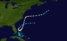
Hurricane Able was a rare hurricane that formed outside of the typical North Atlantic hurricane season. The first tropical cyclone in 1951, Able developed from a trough of low pressure on May 15 about 300 miles (480 km) south of Bermuda. Initially subtropical in nature, Able acquired tropical characteristics as it moved over the warm waters of the Gulf Stream and attained hurricane status on May 17 off the coast of Florida. This made Able one of only four May Atlantic hurricanes on record. On May 22 Able reached peak winds of 90 mph (150 km/h) about 70 miles (115 km) off Cape Hatteras, North Carolina. The hurricane weakened as it turned eastward, and became an extratropical cyclone on May 23.
Hurricane Able did not affect land significantly. In Florida, the storm dropped light precipitation, while in the Bahamas it produced winds of up to 95 mph (152 km/h). From North Carolina through New England, Able produced higher than normal tides. No casualties were reported.
Meteorological history
An active trough of low pressure exited the East Coast of the United States on May 12, and by the following day it passed near Bermuda. Initially the trough was located only near the surface, though as cold air from behind it advanced eastward, the trough extended into the mid- to upper-levels of the atmosphere. By May 14 a closed low pressure area developed in seclusion from the westerlies. Continued cold air from behind the trough, about 12° F (7° C) colder than usual for the time of year, extended across the low in conjunction with warm upper levels and warm sea surface temperatures, resulting in large amounts of instability. The polar trough gradually weakened as the low organized, and on May 15 it developed into a subtropical depression while located about 300 miles (480 km) south of Bermuda.[1]
Located under an upper-level low, the depression initially tracked briskly to the northwest, followed by a turn to the west-southwest on May 16 as the upper-level low turned southwestward. Later on the 16th, the depression approached the warmest waters of the Gulf Stream. Strong divergence from the upper-level low and a high pressure system to its northeast provided favorable conditions towards transitioning into a tropical cyclone,[1] and late on the 16th the depression attained winds of 40 mph (65 km/h).[2] The storm continued to intensify as it turned to the southwest, and early on May 17 a ship near the center reported about 55 mph (88 km/h) winds and up to 30 foot (9 m) waves while located about 125 miles (200 km) east of Daytona Beach, Florida, indicating the system transitioned into a tropical storm. The Navy reconnaissance squadron flew into the system later that day, and reported a storm of full hurricane strength moving southward.[3]
Receiving the name Able, the small hurricane turned to the southeast and to the east while passing near or over the Bahama Banks. Able subsequently turned to the northeast and later to the north, and finished executing its cyclonic loop on May 20. The hurricane continued to intensify with an eye 20 miles (32 km) in diameter, and on May 21 Reconnaissance Aircraft estimated the hurricane attained peak winds of 90 mph (150 km/h). Shortly thereafter Able passed about 70 miles (110 km) east of Cape Hatteras, North Carolina, and early on May 22 Able weakened from its peak intensity after turning to the east. On May 23 it deteriorated into a tropical storm while passing over cooler waters, and that night Able became an extratropical cyclone while located about 520 miles (840 km) south of Halifax, Nova Scotia. The extratropical remnant turned to the northeast before losing its identity late on May 24.[3]
Impact and records
Storm warnings were issued from Savannah, Georgia to Fort Pierce, Florida subsequent to the discovery of the hurricane.[4] The National Weather Bureau advised all small craft to remain at port[5] and recommended residents in the northern Bahamas to take immediate precautions.[6] On Grand Bahama, the threat of Hurricane Able resulted in a construction crew to evacuate further inland; the crew was constructing an observation post for guiding long-range missiles from Cape Canaveral. Fishermen on dozens of boats left the open ocean for safety on two Bahamian islands, while two airplanes safely rode out the hurricane.[7] Small craft warnings and storm warnings were later issued from North Carolina through New England.[8]
The outer rainbands of Able produced light rainfall and high seas along the Florida coastline.[9] While moving slowly near the Bahamas, Able produced strong winds reaching 90 to 95 mph (145 to 152 km/h) at Walker Cay, and minimal hurricane force on Grand Bahama and Little Abaco Island.[3] The hurricane produced high surf in Wilmington, North Carolina and abnormally high tides northward through New England, though no damage was reported.[8] A ship called "City of Eastbourne" sailed through the storm and reported hurricane-force winds, along with "mountainous, confused seas and driving rain."[10]
Able is one of only four North Atlantic hurricanes on record to exist during the month of May, the others occurring in 1889, 1908, and 1970. None of the others reached winds of more than 80 mph (130 km/h). It was described as "wrong way, wrong time", referring to its unusual motion to the southwest near the Bahamas, as well as its presence outside of the normal hurricane season. Additionally, the Weather Bureau described it as a "freak of freaks".[11]
See also
References
- 1 2 Paul Moore and Walter Davis (1951). "A Preseason Hurricane of Subtropical Origin" (PDF). Weather Bureau Office. Retrieved 2007-02-14.
- ↑ National Hurricane Center; Hurricane Research Division (July 6, 2016). "Atlantic hurricane best track (HURDAT version 2)". United States National Oceanic and Atmospheric Administration. Retrieved December 8, 2016.
- 1 2 3 Grady Norton (1952). "Hurricanes of 1951" (PDF). Weather Bureau Office. Retrieved 2007-02-14.
- ↑ Associated Press (1951-05-17). "Hard Winds Reported off Florida Coast".
- ↑ United Press International (1951-05-18). "Premature, Odd Hurricanes Heads for Bahamas".
- ↑ Associated Press (1951-05-18). "Freak Pre-Season Hurricane Perils Southeastern Florida Coastal Area".
- ↑ Associated Press (1951-05-18). "Baby Hurricane Blasts Bahamas".
- 1 2 Associated Press (1951-05-21). "Coast Alerted for Hurricane".
- ↑ United Press (1951-05-18). "Hurricane Hits Florida Coast".
- ↑ Associated Press (1951). "New England Not To Feel Hurricane". Retrieved 2010-01-19.
- ↑ United Press International (1951). "Wrong Time, Wrong Way Hurricane Hits Florida". Retrieved 2010-01-19.
Tropical cyclones of the 1951 Atlantic hurricane season | ||
|---|---|---|
 | ||
| ||