Hosur Road Elevated Expressway
| Bangalore Elevated Tollway Hosur Road Elevated Expressway | |
|---|---|
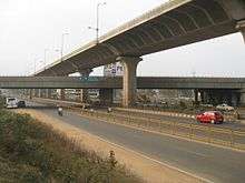 The Bangalore Elevated Tollway as seen over NICE Road | |
| Carries | 4 lanes of road traffic |
| Crosses | Electronics City, Singasandra, Bommanahalli, Bangalore–Mysore Infrastructure Corridor |
| Locale | Bengaluru |
| Official name | Bangalore Elevated Tollway |
| Website | blrelevated.co.in |
| Characteristics | |
| Design | RCC precast structure |
| Total length | 9.985 kilometers (6.204 mi) [1] |
| Height | 17 meters (56 ft) |
| History | |
| Opened | January 22, 2010 |
Bangalore Elevated Tollway or Hosur Road Elevated Expressway is a 9.985 kilometers (6.204 mi) long elevated highway from Madiwala to Electronics City in Bangalore, India. The Bruhat Bengaluru Mahanagara Palike and Bangalore Development Authority have planned a series of flyovers and underpasses to make this arterial road signal free.[2] The project is a part of the BETL (Bangalore Elevated Tollways Ltd), project as part of the National Highways Development Project and the Elevated Highways Project. It was initiated in early 2006, and was inaugurated on 22 January 2010.[3] It starts from Bomanahalli after the Central Silk Board flyover and goes on up to Electronics City. It goes above the BMIC flyover on Hosur Road, at a height of 17 meters (56 ft), thus making it, Bangalore's tallest flyover.[4]
References
- ↑ "Completed Stretches of NHDP Phase 3". National Highways Authority of India. Retrieved 18 May 2012.
- ↑ Manasi (Oct 27, 2009). "Hosur Road widening is in full swing". Bangalore: Bangalore Mirror. Retrieved 27 March 2011.
- ↑ "Expressway Elevates Commuting". Deccan Herald.
- ↑ Sowmya Aji Mehu (9 September 2005). "56-foot-high highway to fly over BMIC road". Bangalore: Times of India. Retrieved 31 March 2011.