Bangalore geography and environment
Bangalore, is situated in the southeast of the South Indian state of Karnataka. It is positioned at 12.97° N 77.56° E and covers an area of 2,190 square kilometres (850 sq mi). A landlocked city, Bangalore is located in the heart of the Mysore Plateau (a region of the larger Deccan Plateau) at an average elevation of 920 metres (3,020 ft). Bangalore district borders with Kolar and Chikkaballapur in the northeast, Tumkur in the northwest, Mandya and Ramanagaram in the southeast and Mysore
Geography

Bangalore lies in the southeast of the South Indian state of Karnataka. It is in the heart of the Mysore Plateau (a region of the larger Precambrian Deccan Plateau) at an average elevation of 920 m (3,020 ft). It is positioned at 12°58′N 77°34′E / 12.97°N 77.56°E and covers an area of 1741 km² (673 mi²). The majority of the city of Bangalore lies in the Bangalore Urban district of Karnataka and the surrounding rural areas are a part of the Bangalore Rural district. The region comprising the Bangalore Urban and Rural districts is known as the Bangalore (region). The Government of Karnataka has carved out the new district of Ramanagara from the old Bangalore Rural district.
In the 16th century, Kempe Gowda I constructed many lakes to meet the town's water requirements. The Kempambudhi Kere, since overrun by modern development, was prominent among those lakes. In the earlier half of 20th century, the Nandi Hills waterworks was commissioned by Sir Mirza Ismail (Diwan of Mysore, 1926–41 CE) to provide water supply to the city. Currently, the river Kaveri provides around 80% of the total water supply to the city with the remaining 20% being obtained from the Thippagondanahalli and Hesaraghatta reservoirs of the Arkavathi river.[1] Bengalooru receives 800 million litres (211 million US gallons) of water a day, more than any other Indian city.[2] However, Bangalore sometimes does face water shortages, especially during the summer season — more so in the years of low rainfall. A random sampling study of the Air Quality Index (AQI) of twenty stations within the city indicated scores that ranged from 76 to 314, suggesting heavy to severe air pollution around areas of traffic concentration.[3]
Bangalore has a handful of freshwater lakes and water tanks, the largest of which are Madivala tank, Hebbal lake, Ulsoor lake and Sankey Tank. Groundwater occurs in silty to sandy layers of the alluvial sediments. The Peninsular Gneissic Complex (PGC) is the most dominant rock unit in the area and includes granites, gneisses and migmatites, while the soils of Bangalore consist of red laterite and red, fine loamy to clayey soils.[3]
Vegetation in the city is primarily in the form of large deciduous canopy and minority coconut trees. Though Bangalore has been classified as a part of the seismic zone III, it has experienced quakes of magnitude as high as 6.4.
Topography
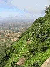
Bangalore has two unique Topography|Topography terrains—North Bangalore taluk and the South Bangalore taluk. The North Bangalore taluk is a relatively more level plateau and lies between an average of 839 to 962 meters above sea level. The middle of the taluk has a prominent ridge running NNE-SSW. The highest point in the city, Doddabettahalli, (962m) is on this ridge. There are gentle slopes and valleys on either side of this ridge. The low-lying area is marked by a series of water tanks varying in size from a small pond to those of considerable extent, but all fairly shallow.
The topography of Bangalore is undulating with a central ridge running NNE-SSW. The highest point is Doddabettahalli, which is 962 m (3,156 ft) and lies on this ridge.[4] No major rivers run through the city, though the Arkavathi and South Pennar cross paths at the Nandi Hills, 60 km (37 mi.) to the north. River Vrishabhavathi, a minor tributary of the Arkavathi, arises within the city at Basavanagudi and flows through the city. The rivers Arkavathi and Vrishabhavathi together carry much of Bangalore's sewage. A sewerage system, constructed in 1922, covers 215 km² (133 mi²) of the city and connects with five sewage treatment centers located in the periphery of Bangalore.[5]
The South Bangalore taluk has an uneven landscape with intermingling hills and valleys. The southern and western portions of the city consist of a topology of granite and gneissic masses. The eastern portion is a plane, with rare minor undulations.
There are no major rivers flowing through the city. However, rivers Arkavathi and Kaveri merge within the proximity of Nandi Hills, which lie 60 km north of Bangalore. River Vrishabhavati, a tributary of Arkavathi, flows for a small stretch in the Bangalore North taluk and carries a bulk of the city's sewerage. The city has a handful of freshwater lakes and water tanks such as Madivala tank, Hebbal tank, Ulsoor lake and Sankey Tank. Groundwater occurs in silty to sandy layers of alluvial sediments and jointed quartzite.
The rock types prevalent in the district belong to the Saugar, Charnokite and Peninsular Gneissic Complex (PGC) groups. The PGC is the dominant group of rocks and covers two-thirds of the area and includes granites, gneissis and migmatites. The soils in Bangalore vary from red laterite to clayey soils.
Climate
| Bangalore | ||||||||||||||||||||||||||||||||||||||||||||||||||||||||||||
|---|---|---|---|---|---|---|---|---|---|---|---|---|---|---|---|---|---|---|---|---|---|---|---|---|---|---|---|---|---|---|---|---|---|---|---|---|---|---|---|---|---|---|---|---|---|---|---|---|---|---|---|---|---|---|---|---|---|---|---|---|
| Climate chart (explanation) | ||||||||||||||||||||||||||||||||||||||||||||||||||||||||||||
| ||||||||||||||||||||||||||||||||||||||||||||||||||||||||||||
| ||||||||||||||||||||||||||||||||||||||||||||||||||||||||||||

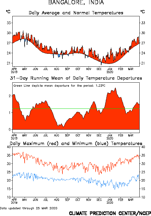
Due to its elevation, Bangalore enjoys a pleasant and equable climate throughout the year. The highest temperature recorded was 39.2 °C (102.0 °F) on 24 April 2016 and the lowest was 7.8 °C in 1884. Winter temperatures rarely drop below 14 °C (52 °F) and summer temperatures seldom exceed 36 °C (97 °F)[6][7]
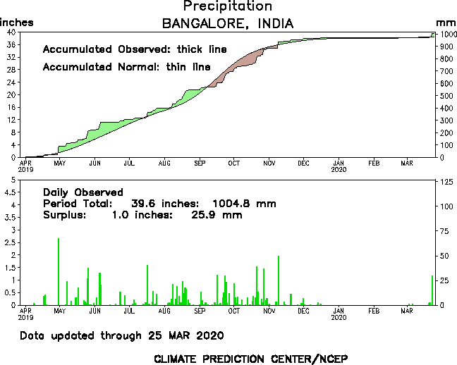
Bangalore receives about 970 mm of rain annually, the wettest months being August September, October and in that order. The summer heat is moderated by fairly frequent thunderstorms and occasional squalls causing power outages and local flooding. The heaviest rainfall recorded in a 24-hour period was 159.7 mm recorded on 1 October 1997 .
Most of the rainfall occurs during late afternoon/evening or night and rain before noon is infrequent. November 2015 (290.4 mm) was recorded as one of the wettest months in Bangalore with heavy rains causing severe flooding in some areas, and closure of a number of organisations for over a couple of days.[8]
Seismicity
Because it lies in the seismically stable region, Zone III (encompassing parts of Karnataka, Maharashtra, Kerala, Tamil Nadu and Andhra Pradesh), Bangalore has been untouched by major seismic events. Only mild tremors have been recorded in the city.
Land Use
| Component | PIU "ideal" Index | Average Score |
| Air Quality | 395 | 180 |
| Water Quality | 130 | 121 |
| Land | 40 | 37 |
| Terrestrial ecosystem | 150 | 143 |
| Aquatic ecosystem | 15 | 12.5 |
| Socio-economic (traffic, quality of life, etc.) |
270 | 49.5 |
| Total | 1000 | 542 |
| Table 1: Adapted from Table 17 of "Environment Impact Analysis" (2003) conducted by Bangalore Mass Rapid Transport Limited (BMRTL) | ||
According to data contained in the Bangalore Mahanagara Palike Master Plan, 40.4% of the land in the city is used for residential purposes. Transport uses 24.3% of the land, while land used for industrial, and commercial purposes comprise 6.9% and 2.7% respectively. As the city of Bangalore expands, the BMP expects the percentage of land used for industrial purposes to decrease, while it expects the percentages of land used for residential, commercial and public and semi-public purposes to increase.
General metropolitan environment
A random sampling study of the Air Quality Index (AQI) of twenty stations within the city indicated scores that ranged from 76-314, suggesting heavy to severe air pollution around areas of traffic concentration. Major pollutants contributing to Bangalore's high AQI score include nitrogen oxide, Suspended Particulate Matter (SPM) and carbon monoxide.
The Bangalore metropolitan area, referred to as the Garden City of India has an abundance of fauna and flora. The city has two nationally renowned botanical gardens—Cubbon Park and Lal Bagh. A majority of the trees in the city are big to medium canopy trees with girths above 40 cm. Coconut trees form a large minority of the tree population in the city.
In 2003, the Battelle Environmental Evaluation System (BEES) index used to evaluate environmental components was used to rate Bangalore's physical, biological and socioeconomic parameters. The results are summarized in Table 1.
See also
References
- ↑ "FAQ". Archived from the original on 6 February 2006. Retrieved 2 July 2007.
- ↑ "Thirsty Bengalooru seeks divine help". Hindustan Times. 2006. HT Media Ltd. 9 June 2003. Archived 23 December 2008 at the Wayback Machine.
- 1 2 ""Environmental Impact Analysis"" (PDF). (362 KB). Bangalore Metropolitan Rapid Transport Corporation Limited.. 2006. Government of Karnataka. 2005.
- ↑ "Studyarea- Bangalore". Centre for Ecological Sciences. 2006. Indian Institute of Science.
- ↑ "Each drop of water counts". Archived from the original on 11 March 2007.. Deccan Herald. 2006. The Printers (Mysore) Ltd. 11 March 2004
- ↑ http://www.imd.ernet.in/section/nhac/dynamic/kkimd.htm
- ↑ http://www.cpc.ncep.noaa.gov/products/global_monitoring/temperature/tn43295_1yr.gif
- ↑ http://www.cpc.ncep.noaa.gov/products/global_monitoring/precipitation/sn43295_1yr.gif
- Bangalore Metropolitan Rapid Transport Limited, Environmental Impact Analysis, 2003 last accessed 6 February 2006.
- Indian Institute of Science, Centre for Ecological Sciences, Study Area: Bangalore last accessed 6 February 2006.
- Visualizing Bangalore weather
Coordinates: 12°58′N 77°34′E / 12.97°N 77.56°E
- Singh. R.L. 1964. Bangalore - an urban survey. Tara Publications, Varanasi, First Edition.
- Venkatarayappa, K.N. 1957. Bangalore (A Socio-Ecological Study). Bombay University Press, Bombay.