Hooker Valley Track
| Hooker Valley Track | |
|---|---|
|
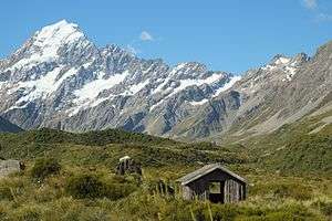
Typical view from along the track - an old shelter at Stocking Stream, in front of Aoraki / Mount Cook | |
| Length | 5 km (3.1 mi) |
| Location | Aoraki/Mount Cook National Park, New Zealand |
| Designation | Walking track |
| Trailheads | White Horse Hill camping ground, Hooker Lake |
| Use | Tramping |
| Elevation | |
| Highest point | Hooker Lake 877 m (2,877 ft)[1] |
| Lowest point | 760 m (2,490 ft)[1] |
| Hiking details | |
| Trail difficulty | Easy |
| Season | All year |
| Sights | Wide glacier valleys with tussock vegetation, glaciers and glacier lakes, moraine ridges, clear views of Aoraki / Mount Cook and other snow-covered peaks (weather permitting) |
| Hazards | Sunburn |
| Surface | Fine gravel, well-formed |
| Website | Department of Conservation |
The Hooker Valley Track is the most popular[2] short walking track within the Aoraki/Mount Cook National Park in New Zealand. At only 5 kilometres (3.1 mi) length and gaining only about 100 m (330 ft) in height, the well formed track can be walked by tourists with a wide range of level of fitness.[3]
The track is maintained by the Department of Conservation and its main attractions are spectacular views of Aoraki / Mount Cook[4][5] and access to the proglacial Hooker Lake, typically with icebergs floating in it. Hooker Valley Track is often named as one of the best day walks in New Zealand.[6][7][8]
The lookout point at the end of the Hooker Valley Track is the closest any walking track comes to Aoraki / Mount Cook,[9] and reveals completely unobstructed views of the highest mountain in New Zealand, with Hooker Glacier in the valley below. There is also access to the shore of the glacial lake. The vegetation around the track is open alpine tussock, and as such the track offers clear views of the mountains surrounding the wide valley floor of the Hooker Valley.
Description
The Hooker Valley Track starts at the White Horse Hill camping ground, which can be reached from Mount Cook Village by either a 4 km (2.5 mi) sealed road, or a walking track of similar length connecting Mount Cook Village with the camping ground. The walking track starts near the Hermitage hotel. Adjacent to the camping ground, there is a car park, toilets, and a large modern shelter with informative panels.
The start of the track leads through open grassland, as it passes close to the Alpine Memorial, a memorial to the mountaineers who have died in the Mount Cook National Park over the years. The memorial site overlooks the proglacial lake of Mueller Glacier.
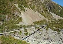
Shortly after the memorial site, the track crosses Hooker River downstream of the Mueller Glacier lake on the first of three solidly built large wooden suspension bridges that were upgraded in 2015.[10] As the track leads around the moraine wall damming Mueller Glacier lake, it crosses Hooker River again, this time upstream of Mueller Glacier lake. After this second bridge, the track continues north further into the wide Hooker Valley, gradually revealing an open view towards the peaks of Aoraki / Mount Cook, which remain visible for the entire second half of the track.
The vegetation in this section of the track changes to snow tussock, spear grass, large mountain daisies, and Mount Cook Lily.[11] All of these alpine plants flower in the summer months between December and February. At times, the track leads close to the Hooker River, its water a bluish light grey colour due to the suspended glacial rock flour in the meltwater. At Stocking Stream, crossed by the track on a small bridge, there is a small wooden shelter, as well as self-composting toilets, the only toilets along the Hooker Valley Track.
North of Stocking Stream, the wide flat valley floor becomes swampy and the track continues on a wooden boardwalk before it reaches the last of the suspension bridges. The track crosses Hooker River a third time, just below the moraine walls of Hooker Lake. A short track leads off the main path to small tarn, before the track skirts around the moraine wall as it climbs gently to the height of the moraine wall, reaching a lookout point with picnic tables, overlooking the proglacial Hooker Lake. From the lookout, a small path leads down to the shore of the lake.
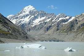
During the summer months, icebergs can be seen floating in the lake, and the lookout also offers views across the lake to the terminus of Hooker Glacier.
Because the track is exposed, there is no protection from the strong sunlight, and wearing sunscreen is advised. In winter, there can be snow and ice on the track, and the lake can freeze over. There are no boat tours on the lake, unlike at the nearby Tasman Lake.
No permit or fee is required to walk the Hooker Valley Track. Dogs or bicycles are not allowed on the track.[3]
Location
| Point | Coordinates (links to map & photo sources) |
Notes |
|---|---|---|
| White Horse Hill camping ground | 43°43′08″S 170°05′37″E / 43.7188°S 170.0935°E | Large shelter with information panels and toilets, next to car park |
| Alpine Memorial | 43°43′05″S 170°05′50″E / 43.7181°S 170.0971°E | Memorial to mountaineers who died in Mount Cook National Park |
| Suspension bridge | 43°42′57″S 170°06′11″E / 43.7158°S 170.1031°E | Bridge over Hooker River downstream of Mueller Glacier lake |
| Suspension bridge | 43°42′20″S 170°06′00″E / 43.7055°S 170.1000°E | Bridge over Hooker River upstream of Mueller Glacier lake |
| Stocking Stream shelter | 43°41′54″S 170°05′49″E / 43.6983°S 170.0969°E | Old shelter and self-composting toilets |
| Suspension bridge | 43°41′34″S 170°05′55″E / 43.6927°S 170.0985°E | Bridge over Hooker River downstream of Hooker Lake |
| Hooker Lake lookout | 43°41′21″S 170°06′12″E / 43.6893°S 170.1033°E | Lookout point with picnic benches |
See also
References
- 1 2 "Hooker Valley Track, Canterbury - NZ Topo Map". NZ Topo Map. Land Information New Zealand. Retrieved 2016-08-30.
- ↑ Liam Cavanagh (1 Aug 2016). "Half a million visitors to Aoraki/Mount Cook tipped as tourism records tumble". Stuff.co.nz. Retrieved 2016-08-30.
- 1 2 "Aoraki/Mount Cook village walking tracks". Department of Conservation. Retrieved 2016-08-30.
- ↑ "Hooker Valley Track". Tourism New Zealand. Retrieved 2016-08-30.
- ↑ Mike Yardley (26 Aug 2016). "Alpine Highs in Aoraki/Mt.Cook". Newstalk ZB. Retrieved 2016-08-31.
- ↑ "DoC walks: NZ's top 8 tracks". The New Zealand Herald. Retrieved 2016-08-30.
- ↑ "5 must-do walks around Mt Cook". Stuff.co.nz. Retrieved 2016-08-30.
- ↑ Shane Gilchrist (8 Aug 2016). "Tough at the top". Otago Daily Times. Retrieved 2016-08-30.
- ↑ "Discover the Outdoors (online map, "HOOKER TK")". Department of Conservation. Retrieved 2016-08-30.
- ↑ Sahiban Kanwal (18 Dec 2015). "Hooker Valley Track gets $1.7m upgrade". Stuff.co.nz. Retrieved 2016-08-30.
- ↑ "Aoraki/Mount Cook Education Resource 2010" (PDF). Department of Conservation. Retrieved 2016-08-30.
External links
- "Aoraki/Mount Cook village walking tracks". Department of Conservation.
Coordinates: 43°41′42″S 170°05′48″E / 43.6949°S 170.0968°E