Mueller Glacier
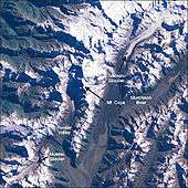
Satellite picture of the Mount Cook region, identifying the Mueller Glacier in the bottom left.
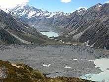
Mueller glacier (under rubble) and its moraine (foreground). Aoraki/Mount Cook washed out in the background. The Hooker Glacier and its terminal lake are up the valley in the distance.
The Mueller Glacier[1] is a 13-kilometre (8.1 mi) long glacier flowing through Aoraki/Mount Cook National Park in the South Island of New Zealand. It lies to the south of Aoraki/Mount Cook, high in the Southern Alps, and flows north. Its meltwaters eventually join the Tasman River.
The glacier was named after German-Australian botanist and explorer Baron von Mueller.[2]
Based on dating of a yellow-green lichen of the Rhizocarpon subgenus, Mueller Glacier is considered to have had a Little Ice Age maximum mass between 1725 and 1730.[3]
See also
- List of glaciers
- Mueller Glacier Glaciers online J. Alean, M. Hambrey
References
- ↑ "Place Name Detail Mueller Glacier". New Zealand Geographic Placenames Database. Retrieved 2010-01-27.
- ↑ Tee, Garry J. (2006). "Science on the Map: Places in New Zealand Named After Scientists". The Rutherford Journal. 2. Retrieved 2008-09-25.
- ↑ Winkler, Stefan (2000). "The 'Little Ice Age' maximum in the Southern Alps, New Zealand: preliminary results at Mueller Glacier". The Holocene. 10 (5): 643–647. doi:10.1191/095968300666087656. Retrieved 2010-06-27.
Coordinates: 43°44′S 170°03′E / 43.733°S 170.050°E
This article is issued from Wikipedia - version of the 11/29/2015. The text is available under the Creative Commons Attribution/Share Alike but additional terms may apply for the media files.