Honeydale Mall
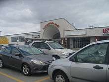 Exterior of Honeydale Mall | |
| Location | 5555 Dundas Street West, Toronto, Ontario, Canada |
|---|---|
| Opening date | 1973 |
| Closing date | June 28, 2013 |
| Owner |
Azuria Group - former Gagnon Law Bozzo Urban Planners - current |
| No. of stores and services | 0 (originally 12) |
| No. of anchor tenants | 0 (originally 2) |
| Total retail floor area | 20,200 m2 (217,000 sq ft) |
| No. of floors | 1 |
Honeydale Mall was a community shopping mall located in Eatonville (part of the former Borough of Etobicoke), Toronto, Canada, at the intersection of Dundas Street and The East Mall Crescent (the latter being a link connecting the grade-separated roads, The East Mall and Dundas Street).
It opened in 1973 with a supermarket anchor, a Woolco department store, and a short enclosed mall. In 1994, Wal-Mart took over the Woolco location and remained in the mall until 2004.
The mall declined after Walmart's departure, and was described as being on "death row".[1] In 2007, The Bay Furniture Outlet opened inside the mall, and then a flea market. But soon, both stores were closed because of low traffic. A clearance warehouse leased the vacant Wal-Mart space annually, but stopped after 2012.
In May 2009, it had two anchor stores (a No Frills supermarket and a flea market), a restaurant and dental office.[2] The mall's No Frills supermarket closed in June 2013, and the entire mall was shuttered and locked up later that year, ending its 40 years of operation.
Azuria Group, the owner of Honeydale, allowed the property to decline and it attempted to pursue high density residential redevelopment options which may include land for a new subway station. However, the application has stalled as the city of Toronto has required Azuria to do studies on the project.[3]
Reasons for decline
Honeydale Mall was one of the numerous post-World War II small neighbourhood community malls that were built in the inner suburbs of Toronto where residential neighbourhoods were growing. All of these community plazas were strip malls with one or two anchors, and most of these fared poorly by the 1990s as shopping trends changed to power centres anchored by big-box stores. The one exception to this was Bayview Village Shopping Centre, which was largely comparable to Honeydale until the 1990s. Unlike Honeydale, the owners of Bayview Village frequently overhauled the property to keep up with current trends, and found high-end independent boutiques not available in larger malls. Bayview Village is located in the affluent areas of Willowdale and Bayview Village where significant transit-oriented condominium development has enabled it to thrive despite being close to the larger Fairview Mall.[1]
Near to where Dundas Street crosses The East Mall is Cloverdale Mall. Both Honeydale and Cloverdale are in the shadow of the considerably larger and affluent Sherway Gardens. Although Cloverdale is only a mid-size retail centre, it has nonetheless managed to thrive as it maintains four anchor stores and undertook a major renovation in 2003-04. By contrast, the owners of Honeydale were reluctant to spend money to keep the mall competitive since the departure of Wal-Mart, instead attempting to rezone the land for sale or a condo development.[1]
An application has been sent to the city by Azuria Group to request the site and the A&P site to the west be re-zoned from industrial class to residential, thus allowing to build homes and condominiums on the site.[4] The proposed residential development is being built by Gagnon Law Bozzo Urban Planners.
Stores
- Woolco (1973-1994; Replaced with Walmart)
- Walmart (1994-2004)
- The Bay Furniture Outlet (Opened 2007)
- No Frills (Closed June 2013)
- Ortho Depot ("Closed April 2001)"
See also
Cloverdale Mall- Located across the street from Honeydale Mall.
Other strip or former strip malls in Toronto:
- Cedarbrae Mall
- Eglinton Square Shopping Centre
- Golden Mile Mall - opened mid-1950s and redeveloped after a fire in the 1980s.
References
- 1 2 3 "A Saga Of Two Plazas". National Post. November 17, 2007. Retrieved March 8, 2010.
- ↑ Jerrold Litwinenko (May 20, 2009). "Nothing Sweet about Etobicoke's Honeydale Mall". BlogTO by FreshDaily. Retrieved March 8, 2010.
- ↑ Tamara Shephard (September 14, 2006). "Subway expansion west to be studied". Metroland Media Group (InsideToronto). Retrieved March 8, 2010.
- ↑ http://www.toronto.ca/legdocs/mmis/2011/ey/bgrd/backgroundfile-42066.pdf
Coordinates: 43°37′46″N 79°32′48″W / 43.62940°N 79.54679°W