Holy Cross Airport
| Holy Cross Airport | |||||||||||
|---|---|---|---|---|---|---|---|---|---|---|---|
 | |||||||||||
| IATA: HCR – ICAO: PAHC – FAA LID: HCA | |||||||||||
| Summary | |||||||||||
| Airport type | Public | ||||||||||
| Owner | State of Alaska DOT&PF - Northern Region | ||||||||||
| Location | Holy Cross, Alaska | ||||||||||
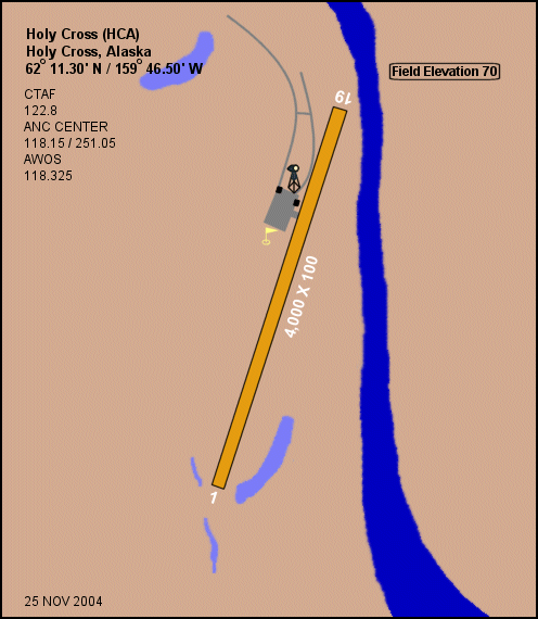
| Elevation AMSL | 70 ft / 21 m | ||||||||||
| Coordinates | 62°11′18″N 159°46′30″W / 62.18833°N 159.77500°W | ||||||||||
| Runways | |||||||||||
| |||||||||||
Holy Cross Airport (IATA: HCR, ICAO: PAHC, FAA LID: HCA, formerly 4Z4) is a state-owned public-use airport located one mile (1.6 km) south of the central business district of Holy Cross, a city in the Yukon-Koyukuk Census Area of the U.S. state of Alaska.[1]
Although most U.S. airports use the same three-letter location identifier for the FAA and IATA, Holy Cross Airport is assigned HCA by the FAA and HCR by the IATA.[2]
Facilities
Holy Cross Airport has one runway (1/19) with a gravel and dirt surface measuring 4,000 x 100 ft. (1,219 x 30 m).[1]
Airlines and destinations
| Airlines | Destinations |
|---|---|
| Frontier Flying Service | Aniak, Anvik[3] |
| Hageland Aviation Services | Aniak, Anvik, Shageluk[4] |
References
- 1 2 3 FAA Airport Master Record for HCA (Form 5010 PDF), effective 2007-12-20
- ↑ Great Circle Mapper: HCR / PAHC - Holy Cross, Alaska
- ↑ Frontier Flying Service: 2007 Timetable (PDF). Retrieved 31-Aug-2007.
- ↑ Hageland Aviation Services: Scheduled Flights (PDF). Retrieved 31-Aug-2007.
External links
- Alaska FAA airport diagram (GIF)
- Resources for this airport:
- FAA airport information for HCA
- AirNav airport information for PAHC
- ASN accident history for HCR
- FlightAware airport information and live flight tracker
- NOAA/NWS latest weather observations for PAHC
- SkyVector aeronautical chart for HCA
This article is issued from Wikipedia - version of the 6/22/2014. The text is available under the Creative Commons Attribution/Share Alike but additional terms may apply for the media files.