Aniak Airport
| Aniak Airport | |||||||||||||||
|---|---|---|---|---|---|---|---|---|---|---|---|---|---|---|---|
 | |||||||||||||||
| IATA: ANI – ICAO: PANI – FAA LID: ANI | |||||||||||||||
| Summary | |||||||||||||||
| Airport type | Public | ||||||||||||||
| Owner | State of Alaska DOT&PF - Central Region | ||||||||||||||
| Serves | Aniak, Alaska | ||||||||||||||
| Elevation AMSL | 89 ft / 27 m | ||||||||||||||
| Coordinates | 61°34′54″N 159°32′35″W / 61.58167°N 159.54306°WCoordinates: 61°34′54″N 159°32′35″W / 61.58167°N 159.54306°W | ||||||||||||||
| Map | |||||||||||||||
 ANI Location of airport in Alaska | |||||||||||||||
| Runways | |||||||||||||||
| |||||||||||||||
| Statistics | |||||||||||||||
| |||||||||||||||
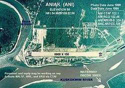
Aniak Airport (IATA: ANI, ICAO: PANI, FAA LID: ANI)[2] is a state owned, public use airport located in Aniak,[1] a city in the Bethel Census Area of the U.S. state of Alaska.[1] Its location on the Kuskokwim River also allows for the landing of seaplanes.[3]
As per Federal Aviation Administration records, the airport had 18,526 passenger boardings (enplanements) in calendar year 2008,[4] 16,255 enplanements in 2009, and 16,394 in 2010.[5] It is included in the National Plan of Integrated Airport Systems for 2011–2015, which categorized it as a primary commercial service airport (more than 10,000 enplanements per year).[6]
Facilities and aircraft
Aniak Airport covers an area of 1,722 acres (697 ha) at an elevation of 89 feet (27 m) above mean sea level. It has one asphalt paved runway designated 10/28 which measures 6,000 by 150 feet (1,829 x 46 m). It also has one seaplane landing area designated 5W/23W on an area of water measuring 3,000 by 400 feet (914 x 122 m). There are 19 aircraft based at this airport: 89.5% single-engine and 10.5% multi-engine.[1]
Airlines and destinations
Passenger
The following airlines offer scheduled passenger service at this airport:
| Airlines | Destinations |
|---|---|
| Ravn Alaska | Anchorage, Chuathbaluk, Holy Cross, Kalskag, Shageluk [7] |
| PenAir | Anchorage [8] |
Cargo
| Airlines | Destinations |
|---|---|
| Ravn Alaska | Anchorage |
| Northern Air Cargo | Anchorage |
References
- 1 2 3 4 FAA Airport Master Record for ANI (Form 5010 PDF). Federal Aviation Administration. Effective April 5, 2012.
- ↑ Great Circle Mapper: ANI / PANI - Aniak, Alaska
- ↑ "Annotated aerial photograph of Aniak Airport" (JPEG). Federal Aviation Administration, Alaska Region. June 1998.
- ↑ "Enplanements for CY 2008" (PDF, 1.0 MB). CY 2008 Passenger Boarding and All-Cargo Data. Federal Aviation Administration. December 18, 2009.
- ↑ "Enplanements for CY 2010" (PDF, 189 KB). CY 2010 Passenger Boarding and All-Cargo Data. Federal Aviation Administration. October 4, 2011.
- ↑ "2011–2015 NPIAS Report, Appendix A" (PDF). National Plan of Integrated Airport Systems. Federal Aviation Administration. October 4, 2010. Archived from the original (PDF, 2.03 MB) on 2012-09-27.
- ↑ "Timetable" (PDF). Era Alaska. Retrieved April 17, 2011.
- ↑ "Mainline Schedule (Alaska)" (PDF). PenAir. February 29, 2012. Retrieved June 16, 2012.
External links
- Topographic map from USGS The National Map
- FAA Alaska airport diagram (GIF)
- FAA Terminal Procedures for ANI, effective November 10, 2016
- Resources for this airport:
- FAA airport information for ANI
- AirNav airport information for PANI
- ASN accident history for ANI
- FlightAware airport information and live flight tracker
- NOAA/NWS latest weather observations for PANI
- SkyVector aeronautical chart for ANI