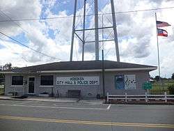
Hoboken, Georgia
| Hoboken, Georgia | |
|---|---|
| City | |
 | |
 Location in Brantley County and the state of Georgia | |
| Coordinates: 31°10′58″N 82°8′2″W / 31.18278°N 82.13389°WCoordinates: 31°10′58″N 82°8′2″W / 31.18278°N 82.13389°W | |
| Country | United States |
| State | Georgia |
| County | Brantley |
| Area | |
| • Total | 3.44 sq mi (8.92 km2) |
| • Land | 3.43 sq mi (8.88 km2) |
| • Water | 0.02 sq mi (0.04 km2) |
| Elevation | 131 ft (40 m) |
| Population (2010) | |
| • Total | 528 |
| • Density | 154/sq mi (59.5/km2) |
| Time zone | Eastern (EST) (UTC-5) |
| • Summer (DST) | EDT (UTC-4) |
| ZIP code | 31542 |
| Area code(s) | 912 |
| FIPS code | 13-39216[1] |
| GNIS feature ID | 0331999[2] |
Hoboken (pronounced ho-bo-kin), is a city in Brantley County, Georgia, United States. It is part of the Brunswick, Georgia Metropolitan Statistical Area. As of the 2010 census, the city had a population of 528.[3]
History
Hoboken served as the first county seat of Brantley County from the county's formation in 1920 until 1923 when the seat was transferred to Nahunta.[4]
Geography
Hoboken is located in western Brantley County at 31°10′58″N 82°8′2″W / 31.18278°N 82.13389°W (31.182720, -82.133891).[5] U.S. Route 82 passes through the city, leading east 9 miles (14 km) to Nahunta, the county seat, and west 14 miles (23 km) to Waycross.
According to the United States Census Bureau, Hoboken has a total area of 3.4 square miles (8.9 km2), of which 0.015 square miles (0.04 km2), or 0.48%, is water.[3]
Demographics
| Historical population | |||
|---|---|---|---|
| Census | Pop. | %± | |
| 1930 | 398 | — | |
| 1940 | 386 | −3.0% | |
| 1950 | 492 | 27.5% | |
| 1960 | 552 | 12.2% | |
| 1970 | 424 | −23.2% | |
| 1980 | 514 | 21.2% | |
| 1990 | 440 | −14.4% | |
| 2000 | 463 | 5.2% | |
| 2010 | 528 | 14.0% | |
| Est. 2015 | 531 | [6] | 0.6% |
As of the census[1] of 2000, there were 463 people, 183 households, and 142 families residing in the city. The population density was 132.7 people per square mile (51.2/km²). There were 202 housing units at an average density of 57.9 per square mile (22.3/km²). The racial makeup of the city was 88.77% White, 8.86% African American, 0.22% from other races, and 2.16% from two or more races. Hispanic or Latino of any race were 1.08% of the population.
There were 183 households out of which 30.1% had children under the age of 18 living with them, 63.9% were married couples living together, 8.7% had a female householder with no husband present, and 22.4% were non-families. 21.3% of all households were made up of individuals and 5.5% had someone living alone who was 65 years of age or older. The average household size was 2.53 and the average family size was 2.92.
In the city the population was spread out with 24.0% under the age of 18, 7.8% from 18 to 24, 24.6% from 25 to 44, 31.3% from 45 to 64, and 12.3% who were 65 years of age or older. The median age was 40 years. For every 100 females there were 104.9 males. For every 100 females age 18 and over, there were 96.6 males.
The median income for a household in the city was $26,818, and the median income for a family was $33,750. Males had a median income of $22,917 versus $20,089 for females. The per capita income for the city was $14,496. About 14.9% of families and 20.0% of the population were below the poverty line, including 25.5% of those under age 18 and 27.1% of those age 65 or over.
Cultural events
Hoboken has a continuous tradition of periodic singings from the Sacred Harp that has continued for over 150 years.[8] These currently include monthly singings and an annual convention.
Twin Oaks Park, located 4 miles (6 km) outside of Hoboken (and with a Hoboken mailing address), hosts two bluegrass conventions every year. It is a privately owned campground, where people from all over can bring their RV's, pop-ups, and listen to the melodic sounds of bluegrass music.
See also
List of county seats in Georgia (U.S. state)
References
- 1 2 "American FactFinder". United States Census Bureau. Retrieved 2008-01-31.
- ↑ "US Board on Geographic Names". United States Geological Survey. 2007-10-25. Retrieved 2008-01-31.
- 1 2 "Geographic Identifiers: 2010 Demographic Profile Data (G001): Hoboken city, Georgia". U.S. Census Bureau, American Factfinder. Retrieved November 5, 2013.
- ↑ Hellmann, Paul T. (May 13, 2013). Historical Gazetteer of the United States. Routledge. p. 240. Retrieved 30 November 2013.
- ↑ "US Gazetteer files: 2010, 2000, and 1990". United States Census Bureau. 2011-02-12. Retrieved 2011-04-23.
- ↑ "Annual Estimates of the Resident Population for Incorporated Places: April 1, 2010 to July 1, 2015". Retrieved July 2, 2016.
- ↑ "Census of Population and Housing". Census.gov. Retrieved June 4, 2015.
- ↑ Kathryn Eastburn (2008), Chapter 5, A Sacred Feast: Reflections on Sacred Harp Singing and Dinner on the Ground. University of Nebraska Press. ISBN 978-0-8032-1831-4.
External links
- Sommers, Laurie Kay (2010) "Hoboken Style: Meaning and Change in Okefenokee Sacred Harp Singing" Southern Spaces ISSN 1551-2754
- Sacred Harp in Hoboken: radio programs, video documentary
- Twin Oaks Park
Municipalities and communities of Brantley County, Georgia, United States | ||
|---|---|---|
| Cities | 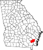 | |
| Unincorporated communities | ||