High Bridge, Reading
| High Bridge | |
|---|---|
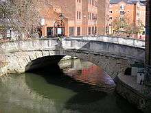 View of High Bridge looking downstream | |
| Coordinates | 51°27′14.85″N 0°58′6.9″W / 51.4541250°N 0.968583°WCoordinates: 51°27′14.85″N 0°58′6.9″W / 51.4541250°N 0.968583°W |
| Carries | London Street |
| Crosses | River Kennet |
| Locale | Reading |
| Heritage status | Grade II listed |
| Characteristics | |
| Design | Arch |
| Material | Portland Stone |
| History | |
| Architect | Robert Furze Brettingham |
| Opened | November 1788 |
High Bridge, sometimes known as Duke Street Bridge, is a bridge across the River Kennet in the town centre of Reading in the English county of Berkshire. It links Duke Street, to its north, and London Street, to its south. High Bridge is the oldest surviving bridge across the Kennet, and is a grade II listed building. It comprises a single arch of vermiculated Portland stone, with a plain keystone of ashlar.[1][2]
The bridge forms the downstream limit of the Brewery Gut, a particularly narrow stretch of the river, and, situated as it is on a blind bend on the river, itself provides a challenge for navigation. For this reason, navigation under the bridge and through the Brewery Gut is controlled by a set of traffic lights on a single-file basis.[2][3]
History
The first bridge in Reading to be built over the Kennet was located at Seven Bridges, in the oldest, Saxon, part of the town. The bridging point now occupied by the High Bridge was probably the second to be used, providing, as it did, a more access to Reading Abbey (founded in 1121) and its environs. Certainly there was a bridge on the site by the time of John Speed's map of 1611, and in 1707 a new wooden bridge was constructed on the site.[4][5]
By 1788, the timber-framed bridge of 1707 required replacement, and a stone bridge able to handle wagon traffic generated by the textile industry was commissioned. Designed by architect Robert Furze Brettingham, it was built at a cost of £3,500.[1][6][7]
For much of its life, the current bridge formed the downstream limit of the stretch of the River Kennet dominated by the presence of Simonds Brewery. Since 1999, it has fulfilled the same role with respect to the riverside precinct of the Oracle shopping centre, which has replaced the brewery, along with the Reading Transport depot on the opposite bank, with riverside restaurants and other leisure facilities.
References
- 1 2 "High Bridge, Reading". British Listed Buildings. Archived from the original on 29 April 2016. Retrieved 9 May 2011.
- 1 2 "11 High Bridge". Reading History Trail. Archived from the original on 26 February 2009. Retrieved 22 January 2015.
- ↑ Clew, Kenneth R (1978). Wessex Waterway - A Guide to the Kennet & Avon Canal. pp. 15–16.
- ↑ "High Bridge". Reading History Trail. Archived from the original on 30 January 2009. Retrieved 22 January 2015.
- ↑ Phillips, Daphne (1980). The Story of Reading. Countryside Books. p. 10. ISBN 0-905392-07-8.
- ↑ Phillips, Daphne (1980). The Story of Reading. Countryside Books. p. 89. ISBN 0-905392-07-8.
- ↑ "Reading in 2003". Berkshire Record Office. Retrieved 9 May 2011.
External links
![]() Media related to High Bridge, Reading at Wikimedia Commons
Media related to High Bridge, Reading at Wikimedia Commons