Hexi District, Tianjin
| Hexi 河西区 | ||||||||||||||||||||||||||||||||||||||||||||||||
|---|---|---|---|---|---|---|---|---|---|---|---|---|---|---|---|---|---|---|---|---|---|---|---|---|---|---|---|---|---|---|---|---|---|---|---|---|---|---|---|---|---|---|---|---|---|---|---|---|
| District | ||||||||||||||||||||||||||||||||||||||||||||||||
|
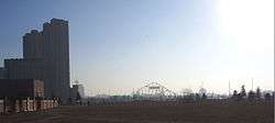
Tianjin Amusement Park within Hexi District | ||||||||||||||||||||||||||||||||||||||||||||||||
| Country | People's Republic of China | |||||||||||||||||||||||||||||||||||||||||||||||
| Municipality | Tianjin | |||||||||||||||||||||||||||||||||||||||||||||||
| Township-level divisions | 13 subdistricts | |||||||||||||||||||||||||||||||||||||||||||||||
| Area | ||||||||||||||||||||||||||||||||||||||||||||||||
| • Total | 37 km2 (14 sq mi) | |||||||||||||||||||||||||||||||||||||||||||||||
| Time zone | China Standard (UTC+8) | |||||||||||||||||||||||||||||||||||||||||||||||
| Tianjin district map |
| |||||||||||||||||||||||||||||||||||||||||||||||
| Website |
tjhx | |||||||||||||||||||||||||||||||||||||||||||||||
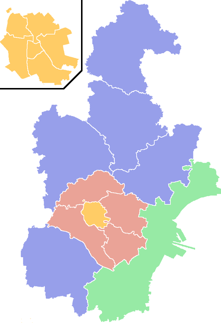
Hexi District (simplified Chinese: 河西区; traditional Chinese: 河西區; pinyin: Héxī Qū; literally: "west of the (Hai) River")" is a district in the south-western corner of urban Tianjin, People's Republic of China. It is bordered by Heping District in the north-west, Hedong District to the north-east and Nankai District to the west.
Administrative divisions
There are 13 subdistricts in the district:[1]
| Name | Chinese (S) | Hanyu Pinyin | Population (2010)[2] |
|---|---|---|---|
| Dayingmen Subdistrict | 大营门街道 | Dàyíngmén Jiēdào | 28,358 |
| Donghai Subdistrict | 东海街道 | Dōnghǎi Jiēdào | 80,013 |
| Taoyuan Subdistrict | 桃园街道 | Táoyuán Jiēdào | 51,061 |
| Guajiasi Subdistrict | 挂甲寺街道 | Guàjiǎsì Jiēdào | 88,190 |
| Machang Subdistrict | 马场街道 | Mǎchǎng Jiēdào | 54,949 |
| Yuexiu Road Subdistrict | 越秀路街道 | Yuèxiùlù Jiēdào | 76,409 |
| Youyi Road Subdistrict | 友谊路街道 | Yǒuyìlù Jiēdào | 77,883 |
| Tianta Subdistrict | 天塔街道 | Tiāntǎ Jiēdào | 83,753 |
| Jianshan Subdistrict | 尖山街道 | Jiānshān Jiēdào | 91,767 |
| Chentangzhuang Subdistrict | 陈塘庄街道 | Chéntángzhuāng Jiēdào | 59,256 |
| Liulin Subdistrict | 柳林街道 | Liǔlín Jiēdào | 101,679 |
| Xiawafang Subdistrict | 下瓦房街道 | Xiàwǎfáng Jiēdào | 49,767 |
| Meijiang Subdistrict | 梅江街道 | Méijiāng Jiēdào | 27,547 |
Transportation
Metro
Hexi is currently served by two metro lines operated by Tianjin Metro:
 Line 1 - Caijindaxue, Huashanli, Fuxingmen, Chentangzhuang, Tucheng, Nanlou, Xiawafang
- Line 3 - Wujiayao
Educational institutions
Major secondary schools
- Xinhua Middle School
- Shiyan Middle School
- Tianjin Fourth Middle School
- Haihe River Middle School
- Senior College of Beijing Normal University, Tianjin
- Tianjin Forty second Middle School
International schools
Universities
- Tianjin University of Finance and Economics
- Tianjin Foreign Languages Institute
- Tianjin University of Science and Technology (formerly the Tianjin Institute of Light Industry)
Attractions
- Tianjin Amusement Park
- Yinhe Park
- Jiefang South Park
- People's Park
Footnotes
- ↑ 2011年统计用区划代码和城乡划分代码:河西区 (in Chinese). National Bureau of Statistics of the People's Republic of China. Retrieved 2013-08-08.
- ↑ shi, Guo wu yuan ren kou pu cha ban gong; council, Guo jia tong ji ju ren kou he jiu ye tong ji si bian = Tabulation on the 2010 population census of the people's republic of China by township / compiled by Population census office under the state; population, Department of; statistics, employment statistics national bureau of (2012). Zhongguo 2010 nian ren kou pu cha fen xiang, zhen, jie dao zi liao (Di 1 ban. ed.). Beijing Shi: Zhongguo tong ji chu ban she. ISBN 978-7-5037-6660-2.
| Districts |  | |
|---|---|---|
| Defunct divisions | ||
Coordinates: 39°06′46″N 117°13′26″E / 39.1128°N 117.224°E
This article is issued from Wikipedia - version of the 10/14/2016. The text is available under the Creative Commons Attribution/Share Alike but additional terms may apply for the media files.