Hergiswil railway station
Hergiswil | |
|---|---|
 | |
| Location |
Bahnhofstrasse Hergiswil, Nidwalden Switzerland |
| Coordinates | 46°58′55″N 8°18′36″E / 46.981965°N 8.309999°ECoordinates: 46°58′55″N 8°18′36″E / 46.981965°N 8.309999°E |
| Elevation | 449 m (1,473 ft) |
| Operated by | Zentralbahn |
| Line(s) |
Brünig line (Zentralbahn) Luzern–Stans–Engelberg line (Zentralbahn) |
| Location | |
 Hergiswil Location within Switzerland | |

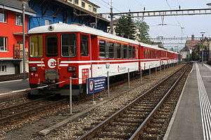
A train in the station
Hergiswil is a Swiss railway station in the municipality of Hergiswil in the canton of Nidwalden. It is at the junction of the Brünig line, which links Lucerne and Interlaken, and the Luzern–Stans–Engelberg line. Both lines are of metre gauge and owned by the Zentralbahn railway company. To the south of the station the Brünig line enters the Lopper I tunnel to Alpnach whilst the Luzern–Stans–Engelberg line enters the Lopper II tunnel to Stansstad.[1][2]
Hergiswil station is one of two stations to serve Hergiswil, the other being Hergiswil Matt, which is on the Brünig line some 1.5 kilometres (0.93 mi) to the north.[1][2]
The station is served by the following passenger trains:[3][4]
| Operator | Train Type | Route | Typical Frequency | Notes |
|---|---|---|---|---|
| Zentralbahn | Lucerne S-Bahn Line S4 |
Lucerne - Lucerne Allmend/Messe - Kriens Mattenhof - Horw - Hergiswil Matt - Hergiswil - Stansstad - Stans - Dallenwil - Wolfenschiessen | 2 per hour 1 per hour |
> Stans Wolfenschiessen |
| Zentralbahn | Lucerne S-Bahn Line S5 |
Lucerne - Kriens Mattenhof - Horw - Hergiswil Matt - Hergiswil - Alpnachstad - Alpnach Dorf - Sarnen - Sachseln - Ewil Maxon - Giswil | 2 per hour |
References
- 1 2 map.geo.admin.ch (Map). Swiss Confederation. Retrieved 2013-01-08.
- 1 2 Eisenbahnatlas Schweiz. Verlag Schweers + Wall GmbH. 2012. p. 22. ISBN 978-3-89494-130-7.
- ↑ "Luzern–Brünig–Interlaken" (PDF). Bundesamt für Verkehr. Retrieved 2013-01-07.
- ↑ "Luzern–Stans–Engelberg" (PDF). Bundesamt für Verkehr. Retrieved 2013-01-14.
External links
-
 Media related to Hergiswil railway station at Wikimedia Commons
This article is issued from Wikipedia - version of the 11/19/2016. The text is available under the Creative Commons Attribution/Share Alike but additional terms may apply for the media files.