Herefordshire Trail
| Herefordshire Trail | |
|---|---|
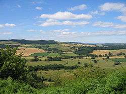
|
Herefordshire Trail leading to Wapley Hillfort | |
| Length | 154 mi (248 km) |
| Location | Herefordshire, England |
| Designation | Long-distance trail |
| Trailheads |
Ledbury, Herefordshire Ledbury, Herefordshire |
| Use | Hiking |
| Elevation | |
| Highest point | Harley's Mountain, 376 m (1,234 ft) |
| Hiking details | |
| Trail difficulty | Easy |
| Season | All year |
The Herefordshire Trail is a long distance footpath forming a circular walk in the English county of Herefordshire.
Route & Distance
The Herefordshire Trail runs for 154 miles (248 km) and forms a circular tour of the county of Herefordshire.
It has been designed to link the five market towns in Herefordshire: Leominster, Bromyard, Ledbury, Ross-on-Wye and Kington, but also taking in many of the smallest villages which are the hidden gems of the area, such as Kilpeck or Leintwardine.
The route encompasses historic churches and inns. The terrain varies from panoramic views at Harley's Mountain (376m, the highest point), Garway Hill Common (366m), and Merbach Hill (318m), and the hidden Golden Valley below the looming bulk of the Black Mountains, Wales, to the river valleys and Black and white villages trail passing through cider orchards and many of the lesser-known hidden places in the secret corners of this quiet county. Interest is provided by the ruined Wilton Castle at Ross-on-Wye, the wooden toll bridge at Whitney-on-Wye, the 1895 Louis Harper pedestrian suspension bridge at Sellack Boat, Arthur's Stone tomb near Dorstone, the sculpted hedges at Brampton Bryan, and the short Kingfisher Line railway near Titley.
The Trail was the outcome of efforts by Herefordshire Council, Advantage West Midlands, the European Union and The Countryside Agency to enrich the rural economies of the towns and villages en route. Sadly Herefordshire Council has failed to make any effort to waymark the route or tackle a long series of obstacles. The path is blocked by cereals, oil seed rape, overgrown and broken stiles, and many of the signs are broken.
Connecting trails
The trails links with the Birmingham and Aberystwyth Walk, Black and White Village Trail, Clun Valley Walk, Elan Valley Way, Geopark Way, Leadon Valley Walks, Marches Way, Monnow Valley Walk, Mortimer Trail, Offa's Dyke Path National Trail, Ross Round, Teme Valley Walk, Teme Valley Way, Upper Lugg Valley Walk, Vaughan's Way and the Wye Valley Walk.
External links
- The Herefordshire Trail website
- Herefordshire Trail - LDWA Long Distance Paths
- Info from the Ramblers Association
- Photos of the Herefordshire Trail on geograph.org.uk
| Wikimedia Commons has media related to Herefordshire Trail. |
Coordinates: 51°54′52″N 2°35′11″W / 51.9144°N 2.5865°W