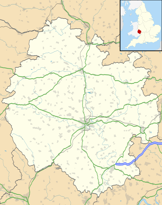
Kington, Herefordshire
| Kington | |
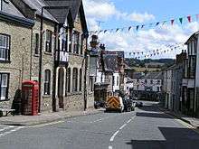
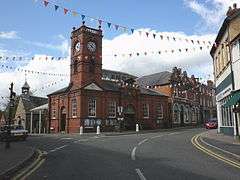 Kington's Market Hall |
|
 Kington |
|
| Population | 3,240 [1][2] |
|---|---|
| OS grid reference | SO297566 |
| – London | 153 miles (246 km) |
| Unitary authority | Herefordshire |
| Ceremonial county | Herefordshire |
| Region | West Midlands |
| Country | England |
| Sovereign state | United Kingdom |
| Post town | Kington |
| Postcode district | HR5 |
| Dialling code | 01544 |
| Police | West Mercia |
| Fire | Hereford and Worcester |
| Ambulance | West Midlands |
| EU Parliament | West Midlands |
| UK Parliament | North Herefordshire |
|
|
Coordinates: 52°12′13″N 3°01′48″W / 52.2035°N 3.03°W
Kington is a market town, electoral ward and civil parish in Herefordshire, England. According to the Parish, the ward had a population of 3,240 while the 2011 census had a population of 2,626.[1][2]
Geography
Kington is 2.0 miles (3.2 km) from the border with Wales and, despite being on the western side of Offa's Dyke, has been English for over a thousand years. The town is in the shadow of Hergest Ridge, and on the River Arrow, where it is crossed by the A44 road. It is 19 miles (31 km) north-west of Hereford, the county town. Nearby towns include Presteigne, Builth Wells, Knighton and Leominster. The centre of the town is situated at 159 metres (522 ft) above sea level.[3] The civil parish covers an area of 347 hectares (860 acres).[2]
History
Kington may have derived from King's-ton, being Anglo-Saxon for "King's Town", similar to other nearby towns such as Presteigne meaning "Priest's Town" and Knighton being "Knight's Town".
Kington is to the west of Offa's Dyke so presumably this land was Welsh in the 8th century AD. The land was held by Anglo-Saxons in 1066, but devastated. After the Norman Conquest Kington then passed to the Crown on the downfall of Roger de Breteuil, 2nd Earl of Hereford in 1075. Before 1121 King Henry I gave Kington to Adam de Port, who founded a new Marcher barony in this part of the early Welsh Marches.[4] Kington seems to have been a quiet barony and was associated with the office of sheriff of Hereford. In 1172, Adam de Port, probably the great-grandson of Henry Port, rebelled and fled the country. He returned in 1174 with a Scottish army, only to flee from the resulting Battle of Alnwick to the great mirth of the Norman court. With this his barony of Kington was taken by the Crown and became an appurtenance of the office of Sheriff of Hereford, finally being granted to William de Braose, 4th Lord of Bramber in 1203 for £100. The castle then saw action in the Braose Wars against King John of England and was probably destroyed by royal forces in August 1216. Within a few years a new fortress was commenced at nearby Huntington Castle and Kington Castle was abandoned. All that remains of Kington Castle today is a great outcrop of rock topped by a few fragmentary earthworks. The old town clustered around the castle and Norman church on top of a defensive hill above the River Arrow.
‘Chingtune' was recorded in the Domesday Book in 1086, the name meaning Kings Town or Manor, high on the hill above the town where St. Mary's Church now stands. The new Kington, called Kyneton in the Fields, was laid out between 1175 and 1230 on land bordering the River Arrow and possibly designated as part of the Saxon open field system.
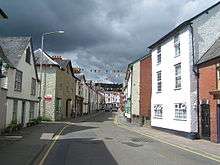
Situated on the direct route the drovers took from Hergest Ridge and with eight annual fairs, Kington grew in importance as a market town and there is still a thriving livestock market on Thursdays. The town retains the medieval grid pattern of streets and back lanes.
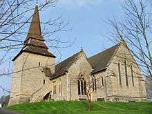
In the chapel of St. Mary's Church, there is the alabaster tomb of Sir Thomas Vaughan of nearby Hergest Court, slain at the Battle of Banbury 1469, and his wife, Elen Gethin. The ghost of Sir Thomas, and also that of the Black Dog of Hergest are said to haunt the area around Hergest Ridge. The Black Dog's sighting reputedly presages death.[5] It is also rumoured to have been the prototype for The Hound of the Baskervilles as Conan Doyle is known to have stayed at nearby Hergest Hall shortly before he wrote the novel.
Governance
An electoral ward in the name of Kington Town exists, called the Herefordshire Council Research Team, for Kington Parish. This ward had a population taken at the Kington Parish of 3,240.[6][7]
Population
| Population | Year |
|---|---|
| 1,424 | 1801 |
| 1,617 | 1811 |
| 1,820 | 1821 |
| 2,142 | 1831 |
| 2,091 | 1841 |
| 1,939 | 1851 |
| 2,178 | 1861 |
| 2,126 | 1871 |
| 2,952 | 1881 |
| 2,086 | 1891 |
| 1,944 | 1901 |
| 1,819 | 1911 |
| 1,688 | 1921 |
| 1,742 | 1931 |
| 1,890 | 1951 |
| 1,856 | 1961 |
| 1,915 | 1971 |
| 2,067 | 1981 |
| 2,147 | 1991 |
| 2,597 | 2001 |
| 3,240 | 2011 |
Source: (Kington Town Parish Data Collected by the Herefordshire Council Research Team)[8]
Climate
As with the rest of the UK, Kington benefits from a maritime climate, with limited seasonal temperature ranges, and generally moderate rainfall throughout the year. The nearest met office weather station is Lyonshall, around 2.5 miles (4.0 km) to the east of the town.
The absolute maximum temperature recorded is 33.5 °C (92.3 °F) during August 1990.[9] In an average year however, the warmest day should record 27.8 °C (82.0 °F),[10] with a total of 7.7 days reporting a value of 25.1 °C (77.2 °F) or above.[11]
The absolute minimum temperature is −16.5 °C (2.3 °F),[12] reported in December 1981. Typically 44 nights should record an air frost.
Rainfall averages around 845 mm (33.3 inches) a year, with over 1 mm (0.039 in) falling on 136 days. All averages refer to the period 1971 to 2000.
| Climate data for Lyonshall, elevation 155 m (509 ft), 1971–2000, extremes 1960–2007 | |||||||||||||
|---|---|---|---|---|---|---|---|---|---|---|---|---|---|
| Month | Jan | Feb | Mar | Apr | May | Jun | Jul | Aug | Sep | Oct | Nov | Dec | Year |
| Record high °C (°F) | 14.1 (57.4) |
16.8 (62.2) |
21.1 (70) |
24.0 (75.2) |
25.5 (77.9) |
31.2 (88.2) |
33.0 (91.4) |
33.5 (92.3) |
25.8 (78.4) |
21.5 (70.7) |
16.6 (61.9) |
14.4 (57.9) |
33.5 (92.3) |
| Average high °C (°F) | 6.4 (43.5) |
6.7 (44.1) |
9.4 (48.9) |
11.9 (53.4) |
15.5 (59.9) |
18.3 (64.9) |
20.9 (69.6) |
20.4 (68.7) |
17.2 (63) |
13.1 (55.6) |
9.4 (48.9) |
7.3 (45.1) |
13.1 (55.6) |
| Average low °C (°F) | 1.1 (34) |
1.0 (33.8) |
2.6 (36.7) |
3.9 (39) |
6.5 (43.7) |
9.3 (48.7) |
11.5 (52.7) |
11.1 (52) |
9.0 (48.2) |
6.3 (43.3) |
3.5 (38.3) |
2.0 (35.6) |
5.7 (42.3) |
| Record low °C (°F) | −15.8 (3.6) |
−12.8 (9) |
−10.6 (12.9) |
−4.2 (24.4) |
−2.2 (28) |
0.8 (33.4) |
2.2 (36) |
3.3 (37.9) |
−0.6 (30.9) |
−4.2 (24.4) |
−7.2 (19) |
−16.5 (2.3) |
−16.5 (2.3) |
| Average precipitation mm (inches) | 91.8 (3.614) |
68.0 (2.677) |
68.0 (2.677) |
58.6 (2.307) |
55.2 (2.173) |
59.2 (2.331) |
46.6 (1.835) |
62.8 (2.472) |
74.9 (2.949) |
81.9 (3.224) |
80.3 (3.161) |
98.5 (3.878) |
845.8 (33.298) |
| Source #1: Met Office[13] | |||||||||||||
| Source #2: KNMI[14] | |||||||||||||
Economy
In the 13th century the new medieval town was formed at the foot of the hill and became primarily a wool-trading market town on an important drovers' road. Its location and historic character is the reason why so many waymarked long-distance footpaths pass through Kington today, including the Mortimer Trail, the Herefordshire Trail and the Offa's Dyke Path. The Black and White Village Trail follows the half-timbered cottages and houses in local Herefordshire villages.
In the 1870s, an assessment was thus: "The trade of the town is chiefly with the agriculturists of the adjoining county of Radnor. There are two banking establishments, viz., the head offices of the Kington and Radnorshire bank (Messrs. Davies, Banks, & Davies), established in 1808, and a branch of the Midland Banking Company, Limited. There is an extensive iron foundry, nail, and agricultural implement manufactory carried on by Messrs. James. Meredith & Co., and the building and tanning trades are well represented. There are also some extensive corn mills and malt-houses. About four miles west of the town are the Old Radnor lime rocks, which are celebrated for their superior quality for building and for agricultural purposes. The market day is Tuesday, considerable business being transacted on that day in eggs, butter, poultry, &c., and is the mart to which the Welsh send their produce, to meet dealers who frequent this town from all quarters."[15]
During the Second World War, the large Kington Camp was constructed close to the town by the War Office. It was first used by the British as a re-grouping point after Dunkirk, housing returned soldiers in often poor conditions. In 1943-4, Wimpeys built two US General Hospitals to cater for predicted wounded from the European campaigns. Each employed 500 US military and administrative personnel and 50 local people. There were administrative buildings, labs, operating theatres and dental clinics as well as personnel quarters, chapels, rehabilitation wards, cinemas, mess halls, warehouses, and laboratories. Between 1944–1945 there were 13,000 patients. After the war buildings were used by the Polish Resettlement Corps (many of the Poles who had fought alongside Western allies did not wish to return to a newly communist dominated Poland). Many of the buildings at the Camp remain standing, although two-thirds have disappeared since the Second World War. Some are used by local businesses.[16]
The Kington economy has suffered along with the fortunes of the farming industry in the area. Its rural location and lack of good transport connections means local unemployment has been high for many decades, with low pay rates and many part-time occupations in small businesses including farming and the retail and service sectors. There is a small tourist industry, though concentrated in the summer months, however it is still an unspoilt town on the borders. The town has a small Co-op supermarket, located off Mill Street near the town centre, as well as a livestock market, situated off Duke Street, and an occasional (usually on Saturdays) market.
Kington Connected (KC3)
A notable exception, that put Kington on the world map, was the Kington Connected Community Company (KC3). KC3 was begun in 1993, when BT, Apple, the Department of Trade and Industry and the Rural Development Commission chose Kington to host a pilot study into the effect that IT and sophisticated telecommunications might have on small communities. 15 ISDN lines were installed for digital data transmission and KC3 became a remote office and payroll service for companies including ICI and banks, with remote "teleworking".[17] There was also significant support to local businesses and schools. In 2006 KC3 split the commercial side from the community and voluntary side. The community and voluntary side ceased trading in March 2007 and Marches Access Point was formed to continue to provide computer access, resource centre and training opportunities. The commercial side of KC3 became KC3.net and in 2009 there was a further management buyout by V8 media which signalled the end of KC3.net.
Education
The town has a primary school and a combined secondary school and sixth form — the Lady Hawkins' School. Sir Francis Drake's cousin Sir John Hawkins married, and in her will, Lady Hawkins left £800 to the town to establish the school.[18] The school is unique in having special permission from the Royal Navy to fly the Red Ensign on its foundress day and is also the secondary school where singer Ellie Goulding attended before moving on to Hereford Sixth Form College.[19]
Transport
The A44 road heads around the town on a bypass; it previously went through the town centre.
Bus services run to Newtown, Powys, Llandridnod Wells, Knighton, Presteigne, Leominster and Hereford. The town has its own bus company, Sargeants Brothers, which was founded in the 1920s, and today provides bus services to Hereford and Mid Wales, though is no longer run by the brothers but their sons. Their bus depot is on Mill Street.
The Kington Tramway opened in 1820 and ran until taken over by the railways.[20]
The Leominster and Kington Railway received royal assent in July 1854, and the 13 miles and 25 chain length opened to Kington in August 1857. Leased to the Great Western Railway from 1862, it was later amalgamated with it. When the Kington and Eardisley Railway replaced the tramway in 1875, it built a new through station at Kington, which it jointly owned with the Leominster and Kington Railway. The old station, slightly to the south, became the goods depot.[21]
Traffic rose during World War II, with the US Army hospital camp at Hergest. Decline set in after the war, and it closed to passengers on 5 February 1955. Freight traffic ceased in 1964, after which the track was taken up and the line abandoned.
Today the nearest station is Knighton on the Heart of Wales Line, though Leominster is quicker to drive to and has more frequent services, being on the Welsh Marches Line.
Shobdon Aerodrome is located close to the town.
Sport
Kington Golf Club at 1,100 feet (340 m) above sea level on Bradnor Hill is the highest golf club in England.[22] It provides wooden shelters on the course for golfers caught out by the weather.
Kington Town F.C. play in the West Midlands (Regional) League.[23]
Kington has also been the host town for the Marin Rough (cycle) Ride since 2003.
Tourism
Kington Museum is open April to September inclusive, and is located on Mill Street in the town centre.[24] Near the town is Hergest Croft Gardens, part of the Hergest Estate, which is open to the public March to October.[25] In June, for several weeks, is the annual Kington Festival in the town.[26]
Ye Olde Tavern is a late 18th/early 19th century Grade II listed public house at 22 Victoria Rd.[27] It is on the Campaign for Real Ale's National Inventory of Historic Pub Interiors.[28]
The Burton Hotel is a relatively large hotel and health centre, situated on Mill Street.[29] The town also has a Youth Hostel, situated on Victoria Road, which is open from late March to late October.[30]
Twinning
Kington has been twinned with the commune of Marines in northern France since 1979.[31] The two places are of a similar population. In Marines there is a residential side-street called "Place Kington", whilst in Kington there is a covered space by the market hall called "Place-de-Marines".
Notable people
- Stephen Kemble, of the acting family, the Kemble family, born here in 1758.
- Mike Oldfield lived at The Beacon, on Bradnor Hill near Kington, in the mid-1970s, the nearby Hergest Ridge inspiring the album of the same name. Oldfield turned parts of the house into a recording studio, where he recorded his 1975 album Ommadawn.
- Australian artist Sidney Nolan lived a few miles north of Kington, right next to the Welsh border, from 1983 until his death. A trust established in his name supports the arts in Herefordshire and further afield, and now owns the property and farmland.
- Pauline Murray, best known for her portrayal of nurse Pauline in the leading role of the 1966 alternate history British film, It Happened Here, died in Kington on New Year's Eve 1994.
- Singer Ellie Goulding and actress Jessica Raine attended school there.
In popular culture
Sue Gee's 2004 novel The Mysteries of Glass is set in and around Kington and Lyonshall in 1860/61 and includes references to many local landmarks.[32]
See also
- Kington G.C.
- Kington Town Council
- Kington Hills
- List of towns in the United Kingdom
References
- 1 2 "2011 CENSUS KEY STATISTICS Kington ward/market town" (PDF). Herefordshire Council. Retrieved 3 November 2015.
- 1 2 3 Office for National Statistics 2011 Census for Kington parish – population and area
- ↑ Ordnance Survey mapping
- ↑ Sanders, I. J. (1960). English Baronies: A Study of Their Origin and Descent 1086–1327. Oxford, UK: Clarendon Press. p. 57. OCLC 931660.
- ↑ Ash, Russell (1973). Folklore, Myths and Legends of Britain. Reader's Digest Association Limited. pp. 320–321. ISBN 9780340165973.
- ↑ "Kington Town ward population 2011". Retrieved 31 October 2015.
- ↑ "Kington Town population data from the Herefordshire Research Team". Retrieved 4 November 2015.
- ↑ https://www.herefordshire.gov.uk/leisure-and-culture/local-history-and-heritage/archives-collections/herefordshire-population/#kington
- ↑ "1990 Maximum". Retrieved 3 March 2011.
- ↑ "1971-00 Average warmest day". Retrieved 3 March 2011.
- ↑ "1971-00 Days >25c". Retrieved 3 March 2011.
- ↑ "1981 Minimum". Retrieved 3 March 2011.
- ↑ "Climate Normals 1971–2000". MetOffice. Retrieved 3 March 2011.
- ↑ "Climate Normals 1971–2000". KNMI. Retrieved 3 March 2011.
- ↑ Source: Extract from Littlebury's Directory and Gazetteer of Herefordshire, 1876-7.
- ↑ Handley F., C. Fforde, J. Gardner & M. Fforde (eds) 2008. The Story of Kington Camp. Hereford: Logaston Press.
- ↑ http://www.tes.co.uk/article.aspx?storycode=97158 A breath of fresh air. TES Magazine, 18 August 1995
- ↑ "Lady Hawkins School History". Archived from the original on 5 March 2009. Retrieved 3 February 2009.
- ↑ "LHS Matters October 2007" (PDF). Retrieved 3 February 2009.
- ↑ Railway Magazine September 1957 pp. 599–605
- ↑ Railway Magazine September 1957 p. 603
- ↑ "Kington Golf Club". Retrieved 7 February 2008.
- ↑ FA Full-time website
- ↑ Kington Museum
- ↑ "Hergest Croft Gardens". Retrieved 7 February 2008.
- ↑ "Kington Festival". Retrieved 7 February 2008.
- ↑ Historic England. "Ye Olde Tavern, Kington (1360790)". National Heritage List for England. Retrieved 20 August 2014.
- ↑ Brandwood, Geoff (2013). Britain's best real heritage pubs. St. Albans: CAMRA. p. 46. ISBN 9781852493042.
- ↑ Burton Hotel
- ↑ YHA Kington
- ↑ Kington Town Council Twin towns
- ↑ KINGTON LIBRARY HOSTED BOOK LAUNCH Retrieved 2 June 2015.
External links
| Unitary authorities | |
|---|---|
| Major settlements | |
| Rivers | |
| Topics | |