Henderson, Tennessee
| Henderson, Tennessee | |
|---|---|
| City | |
|
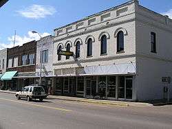
Shops in Henderson | |
 Location of Henderson, Tennessee | |
| Coordinates: 35°26′35″N 88°38′40″W / 35.44306°N 88.64444°WCoordinates: 35°26′35″N 88°38′40″W / 35.44306°N 88.64444°W | |
| Country | United States |
| State | Tennessee |
| County | Chester |
| Area | |
| • Total | 7.86 sq mi (20.37 km2) |
| • Land | 7.84 sq mi (20.30 km2) |
| • Water | 0.03 sq mi (0.07 km2) |
| Elevation | 446 ft (136 m) |
| Population (2010) | |
| • Total | 6,309 |
| • Density | 805/sq mi (310.8/km2) |
| Time zone | Central (CST) (UTC-6) |
| • Summer (DST) | CDT (UTC-5) |
| ZIP code | 38340 |
| Area code(s) | 731 |
| FIPS code | 47-33260[1] |
| GNIS feature ID | 1287374[2] |
| Website |
hendersontn |
Henderson is a city in Chester County, Tennessee, United States. The population was 6,309 at the 2010 census,[3] up from 5,670 at the 2000 census. It is the county seat of Chester County.[4] Chester County was formed from pieces of Hardeman, Henderson, McNairy, and Madison counties in 1882 and named after Robert I. Chester.[5]
Geography
Henderson is located near the center of Chester County at 35°26′35″N 88°38′40″W / 35.44306°N 88.64444°W (35.443025, -88.644345),[6] to the west of the South Fork Forked Deer River. U.S. Route 45 passes through the city, leading northwest 17 miles (27 km) to Jackson and south 20 miles (32 km) to Selmer. Tennessee State Route 100 passes south of the city center, leading east 32 miles (51 km) to Decaturville and west 30 miles (48 km) to Whiteville.
According to the United States Census Bureau, the city has a total area of 7.9 square miles (20.4 km2), of which 0.03 square miles (0.07 km2), or 0.35%, is water.[3]
Demographics
| Historical population | |||
|---|---|---|---|
| Census | Pop. | %± | |
| 1880 | 493 | — | |
| 1890 | 1,069 | 116.8% | |
| 1910 | 1,087 | — | |
| 1920 | 1,181 | 8.6% | |
| 1930 | 1,503 | 27.3% | |
| 1940 | 1,771 | 17.8% | |
| 1950 | 2,532 | 43.0% | |
| 1960 | 2,691 | 6.3% | |
| 1970 | 3,581 | 33.1% | |
| 1980 | 4,449 | 24.2% | |
| 1990 | 4,760 | 7.0% | |
| 2000 | 5,670 | 19.1% | |
| 2010 | 6,309 | 11.3% | |
| Est. 2015 | 6,552 | [7] | 3.9% |
| Sources:[8][9] | |||
As of the census[1] of 2000, there were 5,670 people, 1,896 households, and 1,270 families residing in the city. The population density was 991.6 people per square mile (382.7/km²). There were 2,072 housing units at an average density of 362.4 per square mile (139.9/km²). The racial makeup of the city was 80.09% White, 17.87% African American, 0.09% Native American, 0.41% Asian, 0.37% from other races, and 1.18% from two or more races. Hispanic or Latino of any race were 1.52% of the population.
There were 1,896 households out of which 31.8% had children under the age of 18 living with them, 47.0% were married couples living together, 16.6% had a female householder with no husband present, and 33.0% were non-families. 28.7% of all households were made up of individuals and 14.3% had someone living alone who was 65 years of age or older. The average household size was 2.41 and the average family size was 2.96.
In the city the population was spread out with 21.5% under the age of 18, 25.2% from 18 to 24, 22.5% from 25 to 44, 16.0% from 45 to 64, and 14.8% who were 65 years of age or older. The median age was 27 years. For every 100 females there were 85.4 males. For every 100 females age 18 and over, there were 80.0 males.
The median income for a household in the city was $32,648, and the median income for a family was $40,907. Males had a median income of $32,215 versus $22,258 for females. The per capita income for the city was $16,735. About 15.4% of families and 19.0% of the population were below the poverty line, including 27.6% of those under age 18 and 20.1% of those age 65 or over.
Education
Henderson is part of the Chester County School District and home to Chester County High School. It is also the home of Freed–Hardeman University. Henderson was called Dayton during the Civil War, then was known as Henderson Station and, finally, Henderson.
Notable people
- Eddy Arnold, country musician born in Henderson in 1918
- Jack Dalton, baseball player
- Dorsey B. Hardeman, Texas politician born in Henderson in 1902
- Robby Novak, actor who plays Kid President
- Walton Bryan Stewart, Wisconsin politician born in Henderson in 1914
- Sue Shelton White, national feminist leader and suffragist lawyer
References
- 1 2 "American FactFinder". United States Census Bureau. Retrieved 2008-01-31.
- ↑ "US Board on Geographic Names". United States Geological Survey. 2007-10-25. Retrieved 2008-01-31.
- 1 2 "Geographic Identifiers: 2010 Census Summary File 1 (G001): Henderson city, Tennessee". U.S. Census Bureau, American Factfinder. Retrieved July 6, 2015.
- ↑ "Find a County". National Association of Counties. Retrieved 2011-06-07.
- ↑ "Chester County, TN". chestercountytn.org. Retrieved 2015-09-30.
- ↑ "US Gazetteer files: 2010, 2000, and 1990". United States Census Bureau. 2011-02-12. Retrieved 2011-04-23.
- ↑ "Annual Estimates of the Resident Population for Incorporated Places: April 1, 2010 to July 1, 2015". Retrieved July 2, 2016.
- ↑ "Census of Population and Housing: Decennial Censuses". United States Census Bureau. Retrieved 2012-03-04.
- ↑ "Annual Estimates of the Resident Population: April 1, 2010 to July 1, 2014 (PEPANNRES): Incorporated Places in Tennessee". Population Estimates. U.S. Census Bureau. Retrieved 11 December 2013.
External links
- City of Henderson official website
- Henderson/Chester County Chamber of Commerce
- A Brief History of Chester County
Municipalities and communities of Chester County, Tennessee, United States | ||
|---|---|---|
| City | ||
| Towns | ||
| Unincorporated communities | ||
| Footnotes | ‡This populated place also has portions in an adjacent county or counties | |