Heber City Municipal Airport
| Heber City Municipal Airport Russ McDonald Field | |||||||||||
|---|---|---|---|---|---|---|---|---|---|---|---|
|
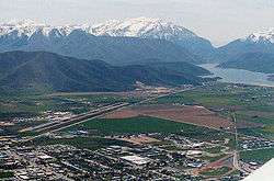
Heber valley, with the airport visible in the left portion of the valley | |||||||||||
| IATA: none – ICAO: none – FAA LID: 36U | |||||||||||
| Summary | |||||||||||
| Airport type | Public | ||||||||||
| Owner | Heber City | ||||||||||
| Serves | Heber City, Utah | ||||||||||
| Elevation AMSL | 5,637 ft / 1,718 m | ||||||||||
| Coordinates | 40°28′54″N 111°25′44″W / 40.48167°N 111.42889°W | ||||||||||
| Runways | |||||||||||
| |||||||||||
| Statistics (2008) | |||||||||||
| |||||||||||
Heber City Municipal Airport (FAA LID: 36U), also known as Russ McDonald Field, is a city owned, public use airport located 1 mi (2 km) south of Heber City, in Wasatch County, Utah, United States,[1] east of Salt Lake City. The airport is untowered and was activated in November 1947.[1] It is included in the National Plan of Integrated Airport Systems for 2011–2015, which categorized it as a general aviation facility.[2]
Facilities and aircraft
Heber City Municipal Airport covers an area of 401 acres (162 ha) at an elevation of 5,637 feet (1,718 m). It has one runway designated 4/22 with an asphalt surface measuring 6,899 by 75 feet.[1]
For the 12-month period ending December 31, 2008, the airport had 28,302 aircraft operations, an average of 77 per day: 94% general aviation, 5% air taxi, and less than 1% military. At that time there were 96 aircraft based at this airport: 69% single-engine, 6% multi-engine, 6% jet, 3% helicopter, and 16% glider.[1]
References
- 1 2 3 4 5 FAA Airport Master Record for 36U (Form 5010 PDF). Federal Aviation Administration. Effective May 31, 2012.
- ↑ "2011–2015 NPIAS Report, Appendix A" (PDF, 2.03 MB). National Plan of Integrated Airport Systems. Federal Aviation Administration. October 4, 2010. External link in
|work=(help)
External links
- Aerial image as of July 1997 from USGS The National Map
- FAA Terminal Procedures for 36U, effective November 10, 2016
- Resources for this airport:
- FAA airport information for 36U
- AirNav airport information for 36U
- FlightAware airport information and live flight tracker
- SkyVector aeronautical chart for 36U