Hauho
| Hauho | ||
|---|---|---|
| Former municipality | ||
| Hauhon kunta | ||
| ||
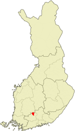 Location of Hauho in Finland | ||
| Coordinates: 61°10′20″N 024°33′45″E / 61.17222°N 24.56250°ECoordinates: 61°10′20″N 024°33′45″E / 61.17222°N 24.56250°E | ||
| Country | Finland | |
| Region | Tavastia Proper | |
| Sub-region | Hämeenlinna sub-region | |
| Charter | 1868 | |
| Consolidated | 2009 | |
| Area[1] | ||
| • Total | 443.37 km2 (171.19 sq mi) | |
| • Land | 354.53 km2 (136.88 sq mi) | |
| • Water | 88.84 km2 (34.30 sq mi) | |
| Population (2008-12-31)[2] | ||
| • Total | 3,934 | |
| • Density | 11.1/km2 (29/sq mi) | |
| Time zone | EET (UTC+2) | |
| • Summer (DST) | EEST (UTC+3) | |

Hauho is a former municipality of Finland. It was situated in the province of Southern Finland and is today a part of the region of Tavastia Proper (Kanta-Häme / Egentliga Tavastland).
Hauho was amalgamated with the municipality of Hämeenlinna on 1 January 2009. Prior to the amalgamation, Hauho – which was unilingually Finnish – had had a population of 3,934 (31 December 2008)[2] and covered an area of 443.13 square kilometres (171.09 sq mi) of which 86.42 square kilometres (33.37 sq mi) was water.[1] The population density was 11.1 inhabitants per square kilometre (29/sq mi).
It has been calculated that Hauho lies at Finland's "population-centre", that is to say: the point in Finland closest on average to the place of residence of every inhabitant of the country.
Lakes Iso-Roine, Hauhonselkä, and Ilmoilanselkä are located in Hauho.
References
- 1 2 "Area by municipality as of 1 January 2008" (PDF) (in Finnish and Swedish). Land Survey of Finland. Retrieved 2 May 2010.
- 1 2 "Population by municipality as of 31 December 2008". Population Information System (in Finnish and Swedish). Population Register Center of Finland. Retrieved 2 May 2010.
External links
![]() Media related to Hauho at Wikimedia Commons
Media related to Hauho at Wikimedia Commons
| Municipalities |  | |
|---|---|---|
| Former municipalities | ||