Harlowton, Montana
| Harlowton, Montana | |
|---|---|
| City | |
|
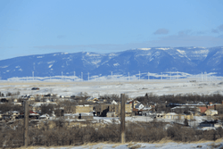
Skyline, Harlowton, MT | |
| Nickname(s): Harlo | |
 Location of Harlowton, Montana | |
| Coordinates: 46°26′11″N 109°50′1″W / 46.43639°N 109.83361°WCoordinates: 46°26′11″N 109°50′1″W / 46.43639°N 109.83361°W | |
| Country | United States |
| State | Montana |
| County | Wheatland |
| Area[1] | |
| • Total | 0.58 sq mi (1.50 km2) |
| • Land | 0.58 sq mi (1.50 km2) |
| • Water | 0 sq mi (0 km2) |
| Elevation | 4,196 ft (1,279 m) |
| Population (2010)[2] | |
| • Total | 997 |
| • Estimate (2015)[3] | 979 |
| • Density | 1,719.0/sq mi (663.7/km2) |
| Time zone | Mountain (MST) (UTC-7) |
| • Summer (DST) | MDT (UTC-6) |
| ZIP code | 59036 |
| Area code(s) | 406 |
| FIPS code | 30-34450 |
| GNIS feature ID | 0772154 |
| Website | http://www.harlowtonchamber.com/ |
Harlowton is a city and is the county seat of Wheatland County, Montana, United States.[4] The population was 997 at the 2010 census. The city was once the eastern terminus of electric operations (1914–74) of the Milwaukee Road railroad's "Pacific Extension" route, which went all the way to Avery, Idaho. Here, steam or diesel locomotives were changed or hooked up to electric locomotives. Harlowton was founded in 1900 as a station stop on the Montana Railroad, a predecessor to the Milwaukee, and was named for Richard A. Harlow,[5] the Montana Railroad's president.
The area around Harlowton is rich in agriculture, the leading products being wheat, barley, cattle, sheep and honey bees.[6] Major employers are Wheatland Memorial Healthcare, Harlowton High School, Hillcrest Elementary School, Musselshell Ranger District, Midtown Market 2 Grocery Store, Rays Sport and Western Wear, Cream of the West, Rocky Mountain Cookware, TicketPrinting.com, and the Judith Gap Wind Farm.[7] The local newspaper is the Times Clarion.
Harlowton is surrounded by the Crazy, Little Belt and Big Snowy Mountains, which are a part of the Lewis and Clark National Forest.[8] The National Forest offers plenty of acreage for recreational activities; camping, sight-seeing, hunting, OHV riding, snowmobiling, etc.[9] Fishing access sites are located along the Musselshell River or at nearby Deadman’s Basin or Martinsdale Reservoir.[10] There are three parks located within Harlowton: Chief Joseph Park, Deer Park, and Fischer Park.[11] The old Milwaukee Railroad track bed has been converted into the “Smoking Boomer” trail. Of special interest are the pioneer bronze sculpture, entitled 'And They Called the Land Montana' and the Veteran’s Honor Wall located in front of the Wheatland County Court House.[12]
The Rodeo, Wheatland County Youth Fair, and Harlowton Kiwanis Show are annual events that take place in Harlowton.[13] Area attractions include the Upper Musselshell Museum, Milwaukee Depot Museum, and Jawbone Creek Country Club.[14] There is a public library, pool, theater, airport, and rifle range.[15] Within 100 miles are the Nez Perce National Historic Trail, Charles M. Bair Museum, and Showdown Ski Area.
|

Prehistory
The Upper Musselshell River Valley is named for the Musselshell River which got its name from the large number of fresh water mussels found in its river bed.[16] In the fall and winter weather, the bison would migrate to the lower altitudes along the Musselshell River. Early plains hunters, taking advantage of the large bison population, frequented this area.[17] Some of the tribes that traveled through the area were the Crow, Blackfeet, Flathead, Gros Ventre, Northern Cheyenne, Nez Perce, Shoshones, Sioux, and Assiniboine.[16]
Harlowton lies within the Montana High Plains that form a part of the Northwestern Plains.[17] The area is most known archeologically for the line of demarcation which was mutually established between the Crow and Blackfeet tribes that passed through the area.[16] This fifty mile rock line fence crossed east to west from the Big Snowy Mountains to the Crazy Mountains.[16] The rock line hunting boundary was the cause of several battles in the area.[16]
Within Wheatland County, site surveys have recorded and assigned Archaeological site numbers to Sentinel Rock, the Fish Creek Pictograph, Owl Canyon Pictograph, Winnecook Petroglyph, Fortification site, and to several buffalo jumps in the area.[17] The Big Snowy, Little Belt, Castle and Crazy Mountains have produced five Wickiup Sites (conical shaped timbered lodges) and several Pictograph sites.[17]
On May 7, 1868, a treaty with the Crow Nation and the United States Government opened the Musselshell River Valley to settlement.[18]
The first sheep operation on the Upper Musselshell was started by P.J. Moore in 1878.[19] The first large cattle operation in the area was the Chicago Montana Livestock Company in 1882 with S.S. Hobson as part owner and manager.[19]
Big Nose George Robbery
In 1878, JV Salazar (Mexican John) was robbed of his horses, grub, and guns near the present site of Harlowton by the noted horse thief George Parrott (Big Nose George).[19] At the time of the Salazar robbery, George Parrott was known to be camping on the Musselshell River with Andrew Garcia where he was holding a bunch of stolen horses on his way to Canada.[19] Big Nose George was later hung at Rawlins, Wyoming.[20]
Merino/Harlowton
The town of Merino was officially established in 1881.[21] The name Merino came from the breed of sheep (Merino) that were run in the area by Charles Severence at the time.[22] The trading post owned by John and Archie McEachnie housed the post office, store and saloon.[22] The first railroad into the area was the Montana Railroad (nicknamed the “Jawbone Railroad”) in 1899.[23] The Montana Railroad terminal was located one mile northwest of Merino, so it was decided to relocate the town site.[21] On June 10, 1900 Richard Harlow, father of the Montana Railroad, and Arthur Lombard, surveyor and promoter of the Montana Railroad, auctioned off lots of the new town site.[22]
The name Merino was changed to Harlowton on November 9, 1900.[21] The first building to be erected in the new town site was a barber shop, owned by Thomas Hanzlik.[22]
On June 17, 1907 a fire destroyed 24 buildings on the north side of Harlowton’s Main Street.[22] The town was re-built, though most of the construction took place on Central Avenue to correspond with the Milwaukee Railroad plot.[22]
The first town election was held on June 6, 1908. Mr. A. T. Anderson was elected mayor.[22]
The grand opening of the Graves Hotel was on June 19, 1909, with a banquet and dance.[22] Andrew Chris Graves was the principal owner.[21] The Graves Hotel was added to the National register of historic places on August 6, 1980.[24]
Wheatland County was created by act of legislature on April 1, 1917, to become the 41st county in Montana. Harlowton became the county seat.[22]
Wheatland County was the first county in the US to go over its’ goal in the World War I Liberty Bond drive of 1918.[21] For this effort, a ship, the USS Wheatland (AKA-85), was named after the county.[22]
The 163rd Infantry Regiment is a regiment of the Montana National Guard based in Harlowton. It went overseas with the 41st Infantry Division in World War II.[25]
Milwaukee Railroad
In 1906 the Milwaukee Railroad started building west with its route coming though Harlowton.[26] On December 5, 1907 work was started on the Milwaukee Railroad Roundhouse in Harlowton.[21] The first passenger train from the east rolled into Harlowton on March 9, 1908, with freight trains to follow.[26] In 1915 the Milwaukee Railroad was electrified from Harlowton to Avery, Idaho; over 450 mountainous miles.[21] Harlowton became the eastern terminus of electric operations and was known as the “the place where electricity replaces steam.”[26] The Milwaukee Railroad dropped its electrified system in 1974, just months before the OPEC oil embargo of the United States.[21] The Milwaukee Railroad was abandoned following a bankruptcy settlement and the last train that went through Harlowton was in March 1979.[27] Milwaukee Road Historic District was listed in the National Register of Historic Places in July 8, 1988.[28] The Depot has been converted into the Harlowton Milwaukee Depot Museum.[29]
Geography and climate
Harlowton is located at 46°26′11″N 109°50′1″W / 46.43639°N 109.83361°W (46.436455, -109.833553).[30]
The town is located on the slopes of the Crazy Mountains. Other surrounding mountain ranges include the Big Snowy Mountains, Little Belt Mountains, Bull Mountains, and the Castle Mountains.
According to the United States Census Bureau, the city has a total area of 0.58 square miles (1.50 km2), all land.[1]
| Climate data for Harlowton, Montana (1981–2010) | |||||||||||||
|---|---|---|---|---|---|---|---|---|---|---|---|---|---|
| Month | Jan | Feb | Mar | Apr | May | Jun | Jul | Aug | Sep | Oct | Nov | Dec | Year |
| Average high °F (°C) | 37.7 (3.2) |
41.1 (5.1) |
49.0 (9.4) |
57.4 (14.1) |
66.9 (19.4) |
75.2 (24) |
84.4 (29.1) |
84.0 (28.9) |
73.1 (22.8) |
59.9 (15.5) |
45.2 (7.3) |
36.7 (2.6) |
59.2 (15.1) |
| Average low °F (°C) | 14.7 (−9.6) |
16.1 (−8.8) |
21.7 (−5.7) |
28.9 (−1.7) |
37.0 (2.8) |
45.0 (7.2) |
49.7 (9.8) |
48.0 (8.9) |
39.7 (4.3) |
30.4 (−0.9) |
21.5 (−5.8) |
14.6 (−9.7) |
30.6 (−0.8) |
| Average precipitation inches (mm) | 0.32 (8.1) |
0.34 (8.6) |
0.66 (16.8) |
1.48 (37.6) |
2.26 (57.4) |
2.81 (71.4) |
1.69 (42.9) |
1.40 (35.6) |
1.00 (25.4) |
0.74 (18.8) |
0.47 (11.9) |
0.40 (10.2) |
13.56 (344.4) |
| Average snowfall inches (cm) | 5.1 (13) |
4.7 (11.9) |
6.0 (15.2) |
4.2 (10.7) |
0.7 (1.8) |
0.0 (0) |
0.0 (0) |
0.0 (0) |
0.8 (2) |
1.3 (3.3) |
3.9 (9.9) |
5.2 (13.2) |
31.9 (81) |
| Source: NOAA[31] | |||||||||||||
Demographics
| Historical population | |||
|---|---|---|---|
| Census | Pop. | %± | |
| 1910 | 770 | — | |
| 1920 | 1,856 | 141.0% | |
| 1930 | 1,473 | −20.6% | |
| 1940 | 1,547 | 5.0% | |
| 1950 | 1,733 | 12.0% | |
| 1960 | 1,734 | 0.1% | |
| 1970 | 1,375 | −20.7% | |
| 1980 | 1,181 | −14.1% | |
| 1990 | 1,049 | −11.2% | |
| 2000 | 1,062 | 1.2% | |
| 2010 | 997 | −6.1% | |
| Est. 2015 | 979 | [32] | −1.8% |
| U.S. Decennial Census[33][34] 2015 Estimate[3] | |||
2010 census
At the 2010 census,[2] there were 997 people, 478 households and 267 families residing in the city. The population density was 1,719.0 inhabitants per square mile (663.7/km2). There were 585 housing units at an average density of 1,008.6 per square mile (389.4/km2). The racial makeup of the city was 95.4% White, 0.7% Native American, 0.2% Asian, 0.5% from other races, and 3.2% from two or more races. Hispanic or Latino of any race were 1.9% of the population.
There were 478 households of which 21.3% had children under the age of 18 living with them, 43.7% were married couples living together, 8.2% had a female householder with no husband present, 4.0% had a male householder with no wife present, and 44.1% were non-families. 40.2% of all households were made up of individuals and 19.9% had someone living alone who was 65 years of age or older. The average household size was 2.03 and the average family size was 2.71.
The median age in the city was 49.8 years. 19.3% of residents were under the age of 18; 5.9% were between the ages of 18 and 24; 19.3% were from 25 to 44; 29.2% were from 45 to 64; and 26.1% were 65 years of age or older. The gender makeup of the city was 48.5% male and 51.5% female.
2000 census
At the 2000 census,[35] there were 1,062 people, 496 households and 281 families residing in the city. The population density was 1,842.9 per square mile (707.0/km²). There were 599 housing units at an average density of 1,039.5 per square mile (398.8/km²). The racial makeup of the city was 97.08% White, 0.75% Native American, 0.19% Asian, 0.19% from other races, and 1.79% from two or more races. Hispanic or Latino of any race were 1.98% of the population.
There were 496 households of which 21.0% had children under the age of 18 living with them, 46.6% were married couples living together, 6.7% had a female householder with no husband present, and 43.3% were non-families. 41.3% of all households were made up of individuals and 21.8% had someone living alone who was 65 years of age or older. The average household size was 2.07 and the average family size was 2.79.
20.9% of the population were under the age of 18, 5.3% from 18 to 24, 20.0% from 25 to 44, 26.4% from 45 to 64, and 27.5% who were 65 years of age or older. The median age was 47 years. For every 100 females there were 91.7 males. For every 100 females age 18 and over, there were 91.8 males.
The median household income was $23,636 and the median family income was $34,205. Males had a median income of $22,750 compared with $19,265 for females. The per capita income was $13,717. About 4.7% of families and 10.3% of the population were below the poverty line, including 8.0% of those under age 18 and 14.1% of those age 65 or over.
Notable people
- Thomas Patrick Gerrity, former United States general and commander of the Air Force Logistics Command, was born here.
References
- 1 2 "US Gazetteer files 2010". United States Census Bureau. Retrieved 2012-12-18.
- 1 2 "American FactFinder". United States Census Bureau. Retrieved 2012-12-18.
- 1 2 "Population Estimates". United States Census Bureau. Retrieved July 19, 2016.
- ↑ "Find a County". National Association of Counties. Retrieved 2011-06-07.
- ↑ "Origins of Names on Milwaukee". Roundup Record-Tribune & Winnett Times. August 22, 1940. p. 6. Retrieved 27 April 2015.
- ↑ "United States Department of Agriculture Farm Service Agency Montana".
- ↑ "Harlowton Chamber of Commerce and Agriculture".
- ↑ "Lewis & Clark National Forest Geographic Divisions".
- ↑ "United States Department of Agriculture Forest Service Recreation".
- ↑ "Montana.gov Official Website" (PDF). Harlowton Fishing Access Site on the Musselshell River.
- ↑ "Harlowton Montana - Live". Parks and Museums.
- ↑ "Welcome to Harlowton Montana".
- ↑ "Harlowton, Montana - Live!". Harlowton Community Events.
- ↑ "Harlowton - Central Montana".
- ↑ "Harlowton Area Chamber of Commerce and Agriculture". Harlowton Brochure.
- 1 2 3 4 5 Stearns, Harold Joseph (1966). A history of the Upper Musselshell Valley of Montana. Harlowton, Montana: Times-Clarion. pp. 1–6 – via OCLC 3498146.
- 1 2 3 4 Harlowton Woman's Club (1972). Yesteryears and Pioneers - Wheatland County. Billings, Montana: Western Printing & Lithography. pp. 286, 287, 325, 326 – via OCLC 641756.
- ↑ "CROW INDIANS. MAY - indianlaw.mt.gov" (PDF).
- 1 2 3 4 Origin and History of Harlowton Montana. Harlowton, Montana: Times Clarion. 1989. p. 17 – via OCLC 43022384.
- ↑ "Big Nose George: A Grisly Frontier Tale | WyoHistory.org".
- 1 2 3 4 5 6 7 8 Origin and History of Harlowton Montana. Harlowton, Montana: Times Clarion. 1989. pp. 9, 18, 28, 29, 30 – via OCLC 43022384.
- 1 2 3 4 5 6 7 8 9 10 Harlowton Woman's Club (1972). Yesteryears & Pioneers. Billings, Montana: Western Printing & Lithography. pp. 102, 221, 295, 296, 302, 341, 343, 351 – via OCLC 641756.
- ↑ Wilkerson, W H (1994). Montana Railroad Company : better known as The Jawbone Railroad. Harlowton, Montana: Times Clarion – via OCLC 45687540.
- ↑ "National Register of Historic Places Inventory—Nomination Form" (PDF).
- ↑ Kidston, Martin J. (2004). From Poplar to Papua - Montana's 163rd Infantry Regiment in World War II. Helena, Montana: FARCOUNTRY PRESS. ISBN 1-56037-314-8.
- 1 2 3 Wilkerson, W H (1992). Lines West Memories. Harlowton, Montana: Times Clarion – via OCLC 45687490.
- ↑ "History of the Milwaukee Road Railroad Company".
- ↑ "United Stales Department of the Interior National Park Service" (PDF). National Register of Historic Places Continuation Sheet.
- ↑ "Central Montana". Harlowton Milwaukee Depot Museum.
- ↑ "US Gazetteer files: 2010, 2000, and 1990". United States Census Bureau. 2011-02-12. Retrieved 2011-04-23.
- ↑ "NOWData - NOAA Online Weather Data". National Oceanic and Atmospheric Administration. Retrieved May 5, 2013.
- ↑ "Annual Estimates of the Resident Population for Incorporated Places: April 1, 2010 to July 1, 2015". Retrieved July 2, 2016.
- ↑ "Census of Population and Housing". Census.gov. Retrieved June 4, 2015.
- ↑ "Census & Economic Information Center". Retrieved July 3, 2015.
- ↑ "American FactFinder". United States Census Bureau. Retrieved 2008-01-31.
Municipalities and communities of Wheatland County, Montana, United States | ||
|---|---|---|
| Cities | 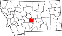 | |
| CDP | ||
| Unincorporated community | ||