Hainesville, Texas
| Hainesville, Texas | |
|---|---|
| Unincorporated community | |
 Hainesville, Texas  Hainesville, Texas | |
| Coordinates: 32°43′03″N 95°21′52″W / 32.71750°N 95.36444°WCoordinates: 32°43′03″N 95°21′52″W / 32.71750°N 95.36444°W | |
| Country | United States |
| State | Texas |
| County | Wood |
| Elevation | 381 ft (116 m) |
| Time zone | Central (CST) (UTC-6) |
| • Summer (DST) | CDT (UTC-5) |
| Area code(s) | 430 & 903 |
| GNIS feature ID | 1378403[1] |
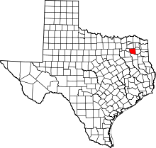
Hainesville is an unincorporated community in Wood County, Texas, United States. Hainesville is located at the intersection of Farm to Market Road 49 and Farm to Market Road 778, 7 miles (11 km) southeast of Quitman. The area around Hainesville was settled in 1845, and Christian H. Haines built a gristmill there in 1870. The Dupree post office moved to the community in 1893; it was renamed Hainesville after Haines. Hainesville had an agricultural economy; settlers primarily grew cotton but also farmed sugar cane, peanuts, melons and peaches. The town's post office closed in 1907, and its schools merged with the Mineola and Quitman districts in the 1960s. Hainesville had a population of 74 in 2000.[2]
Climate
The climate in this area is characterized by hot, humid summers and generally mild to cool winters. According to the Köppen Climate Classification system, Hainesville has a humid subtropical climate, abbreviated "Cfa" on climate maps. [3]
References
- ↑ "Hainesville". Geographic Names Information System. United States Geological Survey.
- ↑ Jenkins, Rachel. "Hainesville, TX". Handbook of Texas Online. Texas State Historical Association. Retrieved April 2, 2013.
- ↑ Climate Summary for Hainesville, Texas
