HM Fort Roughs
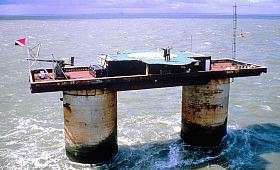

HM Fort Roughs was one of several World War II installations that were designed by Guy Maunsell and known collectively as His Majesty's Forts or as Maunsell Sea Forts; its purpose was to guard the port of Harwich, Essex, and more broadly, the Thames estuary. This 4500 ton artificial naval installation is similar in some respects to "fixed" offshore oil platforms. It is situated on Rough Sands, a sandbar located approximately 11 kilometres (6 nmi) from the coast of Suffolk and 13 kilometres (7 nmi) from the coast of Essex. Today it is the location of the self-proclaimed and unrecognised state, the Principality of Sealand.[1]
History
1942: Construction, positioning, occupation
As a contemporary historical society notes,[2] Fort Roughs or the "Rough Towers" was "the first of originally four naval forts designed by G. Maunsell to protect the Thames Estuary." The artificial sea fort was constructed in dry dock at Red Lion Wharf, Gravesend,[2] in the year preceding and into 1942.
This artificial naval installation is similar in some respects to early "fixed" offshore oil platforms. It consisted of a rectangular 168-by-88-foot (51 by 27 m) reinforced concrete pontoon base with a support superstructure of two 60-foot (18 m) tall, 24-foot (7.3 m) diameter hollow reinforced concrete towers, each roughly 3.5 inches (9 cm) thick; overall weight is estimated to have been approximately 4500 tons.[2] The twin concrete supporting towers were divided into seven floors, four for crew quarters;[2] the remainder provided dining, operational, and storage areas, e.g., for several generators, and for fresh water tanks and antiaircraft munitions. There was a steel framework at one end supporting a landing jetty and crane which was used to hoist supplies aboard; the wooden landing stage itself became known as a "dolphin".[2]
The towers were joined above the eventual waterline by a steel platform deck upon which other structures could be added; this became a gun deck, on which an upper deck and a central tower unit were constructed.[2] QF 3.75 inch anti-aircraft guns were positioned at each end of this main deck, with a further two Bofors 40 mm anti-aircraft guns and the central tower radar installations atop a central living area that contained a galley, medical, and officers quarters.[2]
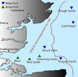
On 11 February 1942 the fort was towed by three tugs to a location on Rough Sands, approximately 10 miles off the Harwich seafront;[2] its base was then intentionally flooded so that it sank in about 37 feet (11 m) of water,[2] coming to rest on the sandbar. At that time Rough Sands was situated in international waters, but the superstructure of the vessel above the waterline remained visible from the coastline of England.
HM Fort Roughs was in operation within 30 minutes of being launched: the crew had been aboard during the fitting out in harbour and were well acquainted with the fort's equipment. Approximately 100 men were assigned to the barge before deployment on Rough Sands; thereafter, the fort was occupied by 150–300 Royal Navy personnel, which continued throughout World War II. At the conclusion of hostilities all original personnel were evacuated from HM Fort Roughs.
1956: Removal of full-time HMG personnel from Roughs Tower
British government official entities used Roughs Tower for a variety of purposes until 1956 when all full-time personnel were finally removed. Roughs Tower remained identified by name on buoys placed in position by the Ministry of Defence which are maintained under an arrangement with Trinity House. Their purpose is to warn vessels of this obstacle, especially in time of fog because busy shipping lanes criss-crossed the area with vessels going to and from the container Port of Felixstowe, Suffolk, and the Port of Harwich, Essex. UK Ordnance Survey now identify the former sea barge fort as Roughs Tower on their charts.
1966: Occupation
In 1966 Paddy Roy Bates, who operated Radio Essex, and Ronan O'Rahilly, who operated Radio Caroline, landed on Fort Roughs and occupied it. However, after disagreements, Roy Bates seized the tower as his own. O'Rahilly attempted to storm the fort in 1967, but Roy Bates defended the fort with guns and petrol bombs and continued to occupy it. The British Royal Marines went on alert and the British authorities ordered Roy Bates to surrender. He and his son were arrested and charged, but the court threw out the case as it did not have jurisdiction over international affairs as Roughs Tower lay beyond the territorial waters of Britain. Bates took this as de facto recognition of his country and seven years later issued a constitution, flag, and national anthem, among other things, for the Principality of Sealand (founded on 2 September 1967). In 1978, a German businessman, along with some other Germans and Dutchmen invaded Roughs Tower but Bates recaptured it and finally released them, after a visit from a German diplomat from its London embassy.[3]
Location
Bob Le-Roi's Fort Fanatics webpage stated on 28 Sep 2011 that modern charts (not available online) using the WGS84 coordinates normally used for GPS, showed the fort at 51°53.71′N 1°28.83′E (i.e. 51°53′42.6″N 1°28′49.8″E). Maritime charts are normally considered more authoritative than land maps for location of maritime obstructions, so those coordinates are chosen for this article. The fort can also be found online on UK government Ordnance Survey maps at grid reference TM3964227615, within 100 m, and on OpenStreetMap within 200 m, of the chart location 51°53′42.6″N 1°28′49.8″E / 51.895167°N 1.480500°E. OpenStreetMap notes that the structure includes a helipad.
References
- ↑ Frank Jacobs (March 20, 2012). "All Hail Sealand". The New York Times.
- 1 2 3 4 5 6 7 8 9 "The Rough Towers: Fort Specifications". The Harwich Society. Retrieved 2014-10-14.
- ↑ Ryan, John; George Dunford; Simon Sellars (2006). Micronations: The Lonely Planet Guide to Home-Made Nations. Lonely Planet. ISBN 1-74104-730-7.
Coordinates: 51°53′42.6″N 1°28′49.8″E / 51.895167°N 1.480500°E