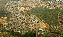
Gungahlin, Australian Capital Territory
| Gungahlin Canberra, Australian Capital Territory | |||||||||||||
|---|---|---|---|---|---|---|---|---|---|---|---|---|---|
 | |||||||||||||
| Coordinates | 35°11′00″S 149°07′55″E / 35.18335°S 149.13185°ECoordinates: 35°11′00″S 149°07′55″E / 35.18335°S 149.13185°E | ||||||||||||
| Population | 5,617 (2011 census)[1] | ||||||||||||
| • Density | 1,221/km2 (3,160/sq mi) | ||||||||||||
| Established | 1998 | ||||||||||||
| Postcode(s) | 2912 | ||||||||||||
| Area | 4.6 km2 (1.8 sq mi) | ||||||||||||
| District | Gungahlin | ||||||||||||
| Territory electorate(s) | Yerrabi | ||||||||||||
| Federal Division(s) | Fenner | ||||||||||||
| |||||||||||||
- For the Canberra district of Gungahlin see: Gungahlin
Gungahlin is a suburb in the Canberra, Australia district with the same name; Gungahlin. The postcode is 2912. Gungahlin is the name for the entire district, and also the town centre, but it is also the name of the suburb which Gungahlin Town Centre is in.
It is next to the suburbs of Ngunnawal, Palmerston, Franklin, Harrison, Throsby, Forde and Amaroo. Burgmann Anglican School is located in the suburb. The edges of the suburb are on Horse Park Drive, Gundaroo Drive and Gungahlin Drive.
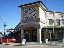
Gungahlin Town Centre
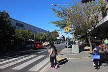
The commercial heart of the Gungahlin Town Centre is Hibberson St, the centre's main street, though the boundary of commercial activities in Anthony Rolfe Avenue, Gundaroo Drive and Gozzard Street. There are currently four retail anchor stores in the town centre, namely Coles, Woolworths, Aldi and Big W which are located in separate developments in Hibberson Street. The only licensed club in the Town Centre is the Raiders Club located at the intersection of Hibberson and Gozzard Streets. The Gungahlin Public Library officially opened in June 2011,[2] and adjoining senior high school opened later that year. Burgmann College is located in the suburb of Gungahlin.
Demographics
In the 2011 Census, the population of Gungahlin was 5,617, including 59 (1.1%) Indigenous persons and 3,306 (58.9%) Australian-born persons.[1] 37.8% of the population was foreign born, the seventh highest for any Canberra suburb.[3]
Geology
The Gungahlin suburb is underlain by the middle Silurian age Canberra Formation. Most of this is slaty shale and mudstone. But there are also a couple of bands of ashstone in the south and north west. The structure of the rock has been folded by anticlines and a syncline with a north east direction. The Gungahlin Fault is parallel to the folds and passes through the east of the town center. To the south it passes through Crace, Kaleen, Bruce and Aranda where it stops at the Deakin Fault. The Gungahlin Fault is also parallel to the Winslade Fault and is no doubt connected with it. In the north east direction it passes out of the ACT northern end and ends near the Sullivans Fault.[4]
Footnotes
- 1 2 Australian Bureau of Statistics (31 October 2012). "Gungahlin (State Suburb)". 2011 Census QuickStats. Retrieved 6 January 2014.
- ↑ Corbell, Simon (17 June 2011). "Minister to officially open $13 million Gungahlin Public Library" (Press release). Archived from the original on 21 February 2014.
- ↑ "Where do migrants live? (4102.0 - Australian Social Trends, 2014)". Australian Bureau of Statistics. 17 March 2014. Retrieved 19 March 2014.
- ↑ Henderson G A M and Matveev G, Geology of Canberra, Queanbeyan and Environs 1:50000 1980.
| Wikimedia Commons has media related to Gungahlin, Australian Capital Territory. |