Golfo Dulce, Costa Rica
Coordinates: 8°35′N 83°16′W / 8.583°N 83.267°W
| Golfo Dulce, Costa Rica | |
|---|---|
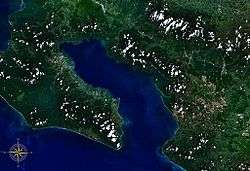 Golfo Dulce seen from space | |
 Golfo Dulce, Costa Rica Location in Costa Rica | |
| Coordinates | 8°35′00″N 83°16′00″W / 8.58333°N 83.26667°W |
Golfo Dulce (English: Sweet Gulf) is a gulf in Costa Rica, located at the South of the Province of Puntarenas. The inlet starts on the Pacific Ocean side of Costa Rica and extends slightly northward before turning west. The most westward part is at the city of Rincon. The bay separates the Osa Peninsula from the mainland Costa Rica.[1]
Protected areas
In the northeast part of the gulf is the Piedras Blancas National Park (former Corcovado National Park extension), with its 14,000 hectares (35,000 acres) of protected rainforest as well as an important marine area to protect the needle-fish. There are a few lodging facilities surrounded by the park, but they are all accessible only by boat.
Translation of the name
In some English literature, this geographical feature is sometimes known as "Gulf of Dulce",[2] which is a mistranslation, as the correct translation would be "Sweet Gulf", and this name in turn, is not used locally or internationally, the correct name stands in all languages as "Golfo Dulce".
References
- ↑ Trejos, Alonso (1991). Geografía Ilustrada Costa Rica (in Spanish). San José, Costa Rica: Trejos Editores. p. 179. ISBN 9977-54-029-2.
- ↑ "Gulf of Dulce". Encyclopædia Britannica.