Greenlee Lough
Coordinates: 55°01′01″N 2°21′00″W / 55.017°N 2.35°W
| Greenlee Lough | |
|---|---|
 Greenlee Lough | |
| OS grid reference | NY776691 |
| |
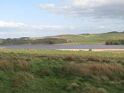
Greenlee Lough is a lough or lake and national nature reserve 3 miles (5 km) north of Bardon Mill, and 1.5 miles (2.4 km)north of the B6318 road in Northumberland, northern England.
| Greenlee Lough | |
|---|---|
 | |
| Location | Northumberland |
| Group | Roman Wall Loughs |
| Coordinates | 55°01′N 2°21′W / 55.017°N 2.350°W |
| Type | mesotrophic |
| Basin countries | United Kingdom |
| Surface area | 0.6 km² |
The lough is owned and managed as a nature reserve by the Northumberland Wildlife Trust and the Northumberland National Park. It is a shallow lake fringed with water plants. Most of the reserve is open water. The lake's edge has reedbed, herb fen and blanket bog. It is used extensively by wildfowl and waders that feed in the shallow waters and wetlands. The lough was used as a reservoir by the Romans on Hadrian's Wall.
Greenlee Sailing Club sailed GP14s,and later Lasers, and Mirrors throughout the 60s. The club closed down in the 70s as members left for the larger, and more accessible, club at Derwent Reservoir near Hexham.
Protected species
The White-clawed crayfish Austropotamobius pallipes is present in the Lough. The species is in decline in Europe, Great Britain, and in northeast England, and is the only crayfish native to the British Isles. It is likely that crayfish have never been widespread in Northumberland National Park as their preferred habitat of calcareous burns, rivers, and lakes is very limited.[1]
See also
References
- ↑ "White-clawed crayfish Species Action Plan" (PDF). Retrieved 2009-04-23.
External links
| Wikimedia Commons has media related to Greenlee Lough. |