Greeleyville, South Carolina
| Greeleyville, South Carolina | |
|---|---|
| Town | |
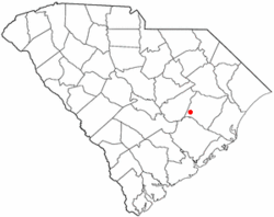 Location of Greeleyville, South Carolina | |
| Coordinates: 33°34′53″N 79°59′22″W / 33.58139°N 79.98944°WCoordinates: 33°34′53″N 79°59′22″W / 33.58139°N 79.98944°W | |
| Country | United States |
| State | South Carolina |
| County | Williamsburg |
| Area | |
| • Total | 1.2 sq mi (3.0 km2) |
| • Land | 1.2 sq mi (3.0 km2) |
| • Water | 0.0 sq mi (0.0 km2) |
| Elevation | 79 ft (24 m) |
| Population (2009) | |
| • Total | 375 |
| • Density | 390.7/sq mi (150.9/km2) |
| Time zone | Eastern (EST) (UTC-5) |
| • Summer (DST) | EDT (UTC-4) |
| ZIP code | 29056 |
| Area code(s) | 843 |
| FIPS code | 45-30535[1] |
| GNIS feature ID | 1245822[2] |
Greeleyville is a town in Williamsburg County, South Carolina, United States. The population was 375 at the 2009 census.
History
The Clarkson Farm Complex, McCollum-Murray House, and New Market are listed on the National Register of Historic Places.[3]
Geography
Greeleyville is located at 33°34′53″N 79°59′22″W / 33.58139°N 79.98944°W (33.581303, -79.989399).[4]
According to the United States Census Bureau, the town has a total area of 1.2 square miles (3.1 km2), all of it land.
Demographics
| Historical population | |||
|---|---|---|---|
| Census | Pop. | %± | |
| 1900 | 252 | — | |
| 1910 | 630 | 150.0% | |
| 1920 | 645 | 2.4% | |
| 1930 | 474 | −26.5% | |
| 1940 | 633 | 33.5% | |
| 1950 | 600 | −5.2% | |
| 1960 | 504 | −16.0% | |
| 1970 | 542 | 7.5% | |
| 1980 | 593 | 9.4% | |
| 1990 | 464 | −21.8% | |
| 2000 | 452 | −2.6% | |
| 2010 | 438 | −3.1% | |
| Est. 2015 | 409 | [5] | −6.6% |
As of the census[1] of 2009, there were 375 people, 163 households, and 118 families residing in the town. The population density was 390.7 people per square mile (150.4/km²). There were 188 housing units at an average density of 162.5 per square mile (62.6/km²). The racial makeup of the town was 39.82% White, 58.19% African American, 0.88% Asian, 1.11% from other races. Hispanic or Latino of any race were 2.65% of the population.
There were 163 households out of which 36.8% had children under the age of 18 living with them, 48.5% were married couples living together, 19.6% had a female householder with no husband present, and 27.6% were non-families. 25.8% of all households were made up of individuals and 11.0% had someone living alone who was 65 years of age or older. The average household size was 2.77 and the average family size was 3.34.
In the town the population was spread out with 31.2% under the age of 18, 7.7% from 18 to 24, 25.2% from 25 to 44, 23.2% from 45 to 64, and 12.6% who were 65 years of age or older. The median age was 36 years. For every 100 females there were 89.9 males. For every 100 females age 18 and over, there were 92.0 males.
The median income for a household in the town was $32,375, and the median income for a family was $32,344. Males had a median income of $27,969 versus $17,500 for females. The per capita income for the town was $17,971. About 23.2% of families and 19.6% of the population were below the poverty line, including 20.8% of those under age 18 and 25.5% of those age 65 or over.
See also
References
- 1 2 "American FactFinder". United States Census Bureau. Retrieved 2008-01-31.
- ↑ "US Board on Geographic Names". United States Geological Survey. 2007-10-25. Retrieved 2008-01-31.
- ↑ National Park Service (2010-07-09). "National Register Information System". National Register of Historic Places. National Park Service.
- ↑ "US Gazetteer files: 2010, 2000, and 1990". United States Census Bureau. 2011-02-12. Retrieved 2011-04-23.
- ↑ "Annual Estimates of the Resident Population for Incorporated Places: April 1, 2010 to July 1, 2015". Retrieved July 2, 2016.
- ↑ "Census of Population and Housing". Census.gov. Retrieved June 4, 2015.
Municipalities and communities of Williamsburg County, South Carolina, United States | ||
|---|---|---|
| Towns | 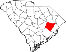 | |
| Unincorporated communities | ||
| Footnotes | ‡This populated place also has portions in an adjacent county or counties | |