Great Mackerel Beach, New South Wales
| Great Mackerel Beach Sydney, New South Wales | |||||||||||||
|---|---|---|---|---|---|---|---|---|---|---|---|---|---|
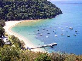 Great Mackerel Beach, photographed from the south | |||||||||||||
| Population | 103 (2006 census)[1] | ||||||||||||
| Postcode(s) | 2108 | ||||||||||||
| Location | 43 km (27 mi) north of Sydney CBD | ||||||||||||
| LGA(s) | Northern Beaches Council | ||||||||||||
| State electorate(s) | Pittwater | ||||||||||||
| Federal Division(s) | Mackellar | ||||||||||||
| |||||||||||||
Great Mackerel Beach is a suburb 43 kilometres north of the Sydney central business district in the local government area of Northern Beaches Council, Sydney, New South Wales, Australia.[2] It is on the western shores of Pittwater in Ku-ring-gai Chase National Park, beside Currawong Beach, and near Coasters Retreat and Palm Beach.
Great Mackerel Beach is frequently referred to as Mackerel Beach or [Great] Mackeral Beach (both spellings are sometimes used in the same document[3]). Nearby Currawong Beach is sometimes called Little Mackerel Beach.[4]
Geography
The Mackerel valley was formed by a creek that flows from within the National Park, passing through sub-tropical rain forest and mangroves to exit at the north end of the beach where a sand delta has been formed. The sand on the beach is the result of sandstone flowing down the Hawkesbury River Hawkesbury River and is soft and golden.
History
Mackerel was originally a dairy farm settled in 1823 by a John Clark who sold it on to Martin Burke who is known as "The Father of Pittwater". Subdivision of Mackerel took place in 1920 and since then over 100 houses have been built. Originally most of the houses were fibro shacks built as fishermen’s cottages and weekenders however much development has occurred since and now Mackerel has a large variety of homes ranging from some of the original shacks to waterfront mansions.
Facilities
Transport
Great Mackerel Beach has no road access and no roads or vehicles; access is by the Palm Beach Ferry, water taxi, or private boat.
Visitor facilities
There are no shops, public toilets, barbecue or picnic facilities, public rubbish facilities, or public drinking water taps at Great Mackerel Beach.
There is a public telephone booth near the wharf.
Recreational boating
There are no moorings available for visiting recreational boating at Great Mackerel Beach, including no Commercial/Club (orange) or Courtesy (pink) moorings. Visiting recreational boats may not tie-up on Great Mackerel Beach Wharf.[5] Private (yellow) moorings may not be used by non-owners and may not be sublet or traded in any way.[6]
The Mackerel Community
MBA
The Mackerel Beach Association is a group of about twenty property owners who represent the wider community on issues such as parking and garbage collection.
Pet dogs
Due to its position bordering the Ku-ring-gai National Park, pet dogs have historically been prohibited from Mackerel Beach, as they are at The Basin and Currawong and other communities positioned along the western foreshores of Pittwater.
In 2007 some residents asked the MBA for a leash-free area on the south end of the beach. This was rejected by the MBA at the AGM; the residents then raised the request with Pittwater Council, which decided to run a six-month trial of a Public Dog Exercise Area (PDEA) at the north end of the beach. Many residents disagreed with this decision. The area defined by the PDEA prohibited dogs from being walked past the northernmost house, as this region constitutes part of Ku-ring-gai Chase National Park, home to many native mammals, reptiles and bird species.
In 2008 the National Parks and Wildlife Service submitted a report to Pittwater Council that advised against a PDEA at Mackerel Beach.
In December 2009 Pittwater Council resolved to permanently allow dogs off leads at Mackerel Beach between the public wharf north to the last house/National Park boundary, with restrictions. The regulations are difficult to enforce in sparsely-populated and isolated Mackerel Beach. There was a reported injury due to attack by a pet dog in 2012.
Cats
Pittwater Council also banned pet cats from Mackerel Beach due to their impact on the native wildlife.
References
- ↑ Australian Bureau of Statistics, 2006. Censusdata.abs.gov.au. Retrieved on 2012-02-01.
- ↑ [Geographical Names Register (GNR) of NSW. Geographical Names Board of New South Wales http://www.gnb.nsw.gov.au/place_naming/placename_search/extract?id=MaKqFxxOGH. Missing or empty
|title=(help) "Great Mackerel Beach"] Check|url=value (help). Retrieved 31 May 2013. - ↑ Great Mackeral Beach. Pittwater Council. Pittwater.nsw.gov.au. Retrieved on 2012-02-01.
- ↑ Mackerel is surrounded on three sides by the Ku-ring-gai Chase National Park, with a beach leading to the water Pittwater. The suburb of Currawong Beach adjoins to the south. T and offers residents a year round holiday lifestyle, isolated from the hustle and bustle of the city, yet only a 10-minute boat ride back to "the mainland". The beach is soft golden sand and is ideal for swimming as the southern end becomes deep quite quickly and the northern end has a lovely large sandbank which gradually protrudes into the water Great Mackerel Beach Reserve. Pittwater Council. Pittwater.nsw.gov.au. Retrieved on 2012-02-01.
- ↑ Moorings – General Information. Maritime.nsw.gov.au (2009-02-16). Retrieved on 2012-02-01.
- ↑ Private Moorings. Maritime.nsw.gov.au (2009-02-16). Retrieved on 2012-02-01.
Coordinates: 33°35′30″S 151°18′3″E / 33.59167°S 151.30083°E