Granite Falls, Minnesota
| Granite Falls | |
|---|---|
| City | |
| Granite Falls, Minnesota | |
|
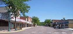
Prentice Street in downtown Granite Falls in 2007 | |
 Location of Granite Falls within Yellow Medicine County, Minnesota | |
| Coordinates: 44°48′38″N 95°32′36″W / 44.81056°N 95.54333°W | |
| Country | United States |
| State | Minnesota |
| Counties | Chippewa, Renville, Yellow Medicine |
| Area[1] | |
| • Total | 3.82 sq mi (9.89 km2) |
| • Land | 3.59 sq mi (9.30 km2) |
| • Water | 0.23 sq mi (0.60 km2) |
| Elevation | 919 ft (280 m) |
| Population (2010)[2] | |
| • Total | 2,897 |
| • Estimate (2013)[3] | 2,806 |
| • Density | 807.0/sq mi (311.6/km2) |
| Time zone | Central (CST) (UTC-6) |
| • Summer (DST) | CDT (UTC-5) |
| ZIP code | 56241 |
| Area code(s) | 320 |
| FIPS code | 27-25280[4] |
| GNIS feature ID | 0644347[5] |
| Website | City of Granite Falls |
Granite Falls is a city in Chippewa, Renville and Yellow Medicine counties in the State of Minnesota. The population was 2,897 at the 2010 census.[6] It is the county seat of Yellow Medicine County.[7] The Andrew John Volstead House, a National Historic Landmark, is located in Granite Falls.
History
Granite Falls was platted in 1872.[8] The city was named for deposits of granite rock in the area.[9] A post office has been in operation at Granite Falls since 1870.[10] Granite Falls was incorporated as a city in 1889.[8]
Granite Falls 2000 tornado
On July 25, 2000, the city of Granite Falls and Yellow Medicine County were hit by a powerful tornado. The tornado first touched down in rural parts of the county west-northwest of Granite Falls, hitting the city at 6:10 pm. After tearing through the residential sections of town, the tornado lifted at approximately 6:25PM after being on the ground for over nine miles. One person was killed, more than a dozen were injured, and the town and surrounding area suffered millions of dollars in property damage.
While the damage in Granite Falls was generally limited to that of F-2 and F-3 storms, the extent of the damage at the corner of 9th Avenue and 14th Street caused the National Weather Service to classify it as an F-4 storm.
Geography
According to the United States Census Bureau, the city has a total area of 3.82 square miles (9.89 km2); 3.59 square miles (9.30 km2) is land and 0.23 square miles (0.60 km2) is water.[1]
U.S. Highway 212 and Minnesota State Highways 23 and 67 are three of the main routes in the city.
Climate
Granite Falls, along with the rest of Minnesota, has a humid continental climate[11] with significant differences between seasons. With a July mean temperature of 22.2 °C (72.0 °F) Granite Falls just falls into the hot-summer zone of the Köppen classification of the humid continental climate regime.[12] Winters are cold and dry influenced by arctic air masses affecting it through its continental position, while summers are influenced by humid subtropical air masses bringing hot temperatures and significant rainfall. Transitional periods are very short, since only April and October are between 0 °C (32 °F) and 10 °C (50 °F) in daily mean temperatures, with May–September being clearly above and November–March averaging below freezing.[12] The middle three months in each of those cycles are also clearly warmer and colder, respectively, than the months at the beginning or at the end of transitional periods. That is in turn a typical feature of continental climates.
| Climate data for Granite Falls | |||||||||||||
|---|---|---|---|---|---|---|---|---|---|---|---|---|---|
| Month | Jan | Feb | Mar | Apr | May | Jun | Jul | Aug | Sep | Oct | Nov | Dec | Year |
| Average high °C (°F) | −4.6 (23.7) |
−1.9 (28.6) |
4.4 (39.9) |
14.2 (57.6) |
21.6 (70.9) |
26.4 (79.5) |
29.2 (84.6) |
27.7 (81.9) |
22.9 (73.2) |
15.2 (59.4) |
5.4 (41.7) |
−3.3 (26.1) |
13.2 (55.8) |
| Daily mean °C (°F) | −10.8 (12.6) |
−8.1 (17.4) |
−1.1 (30) |
7.3 (45.1) |
14.4 (57.9) |
19.6 (67.3) |
22.2 (72) |
20.9 (69.6) |
15.6 (60.1) |
8.1 (46.6) |
−0.4 (31.3) |
−8.6 (16.5) |
6.7 (44.1) |
| Average low °C (°F) | −17.1 (1.2) |
−14.2 (6.4) |
−6.7 (19.9) |
0.5 (32.9) |
7.3 (45.1) |
12.8 (55) |
15.3 (59.5) |
14.1 (57.4) |
8.1 (46.6) |
0.9 (33.6) |
−6.2 (20.8) |
−13.9 (7) |
0.2 (32.4) |
| Average precipitation mm (inches) | 17.8 (0.701) |
17.8 (0.701) |
33.0 (1.299) |
61.0 (2.402) |
76.2 (3) |
91.4 (3.598) |
76.2 (3) |
83.8 (3.299) |
83.8 (3.299) |
61.0 (2.402) |
35.6 (1.402) |
17.8 (0.701) |
655.3 (25.799) |
| Source: [13] | |||||||||||||
Demographics
| Historical population | |||
|---|---|---|---|
| Census | Pop. | %± | |
| 1880 | 578 | — | |
| 1890 | 800 | 38.4% | |
| 1900 | 1,214 | 51.8% | |
| 1910 | 1,454 | 19.8% | |
| 1920 | 1,611 | 10.8% | |
| 1930 | 1,791 | 11.2% | |
| 1940 | 2,388 | 33.3% | |
| 1950 | 2,511 | 5.2% | |
| 1960 | 2,728 | 8.6% | |
| 1970 | 3,225 | 18.2% | |
| 1980 | 3,451 | 7.0% | |
| 1990 | 3,083 | −10.7% | |
| 2000 | 3,070 | −0.4% | |
| 2010 | 2,897 | −5.6% | |
| Est. 2015 | 2,747 | [14] | −5.2% |
| U.S. Decennial Census[15] 2013 Estimate[3] | |||
2010 census
As of the census[2] of 2010, there were 2,897 people, 1,282 households, and 747 families residing in the city. The population density was 807.0 inhabitants per square mile (311.6/km2). There were 1,417 housing units at an average density of 394.7 per square mile (152.4/km2). The racial makeup of the city was 89.9% White, 0.6% African American, 5.2% Native American, 0.4% Asian, 1.8% from other races, and 2.1% from two or more races. Hispanic or Latino of any race were 4.7% of the population.
There were 1,282 households of which 25.7% had children under the age of 18 living with them, 44.1% were married couples living together, 10.1% had a female householder with no husband present, 4.1% had a male householder with no wife present, and 41.7% were non-families. 37.2% of all households were made up of individuals and 17.2% had someone living alone who was 65 years of age or older. The average household size was 2.17 and the average family size was 2.82.
The median age in the city was 43 years. 21.5% of residents were under the age of 18; 8.8% were between the ages of 18 and 24; 22.3% were from 25 to 44; 26.9% were from 45 to 64; and 20.7% were 65 years of age or older. The gender makeup of the city was 48.4% male and 51.6% female.
2000 census
As of the census[4] of 2000, there were 3,070 people, 1,344 households, and 806 families residing in the city. The population density was 890.5 people per square mile (343.6/km²). There were 1,472 housing units at an average density of 427.0 per square mile (164.7/km²). The racial makeup of the city was 92.35% White, 0.07% African American, 5.70% Native American, 0.16% Asian, 0.42% from other races, and 1.30% from two or more races. Hispanic or Latino of any race were 2.15% of the population.
There were 1,344 households out of which 27.7% had children under the age of 18 living with them, 50.5% were married couples living together, 7.7% had a female householder with no husband present, and 40.0% were non-families. 35.0% of all households were made up of individuals and 18.5% had someone living alone who was 65 years of age or older. The average household size was 2.24 and the average family size was 2.91.
In the city the population was spread out with 24.1% under the age of 18, 7.9% from 18 to 24, 24.1% from 25 to 44, 22.0% from 45 to 64, and 21.8% who were 65 years of age or older. The median age was 41 years. For every 100 females there were 86.1 males. For every 100 females age 18 and over, there were 81.2 males.
The median income for a household in the city was $32,031, and the median income for a family was $45,536. Males had a median income of $32,905 versus $22,957 for females. The per capita income for the city was $18,356. About 6.6% of families and 9.7% of the population were below the poverty line, including 6.8% of those under age 18 and 10.6% of those age 65 or over.
Cultural references
- In the film A Prairie Home Companion, the character of Guy Noir, played by Kevin Kline, asks radio host Garrison Keillor to send him a signal if he sees a dangerous woman in white in the audience. One of the multiple signals he chooses is the use of the phrase 'Granite Falls'.
References
- 1 2 "US Gazetteer files 2010". United States Census Bureau. Retrieved 2012-11-13.
- 1 2 "American FactFinder". United States Census Bureau. Retrieved 2012-11-13.
- 1 2 "Population Estimates". United States Census Bureau. Retrieved 2014-10-28.
- 1 2 "American FactFinder". United States Census Bureau. Retrieved 2008-01-31.
- ↑ "US Board on Geographic Names". United States Geological Survey. 2007-10-25. Retrieved 2008-01-31.
- ↑ "2010 Census Redistricting Data (Public Law 94-171) Summary File". American FactFinder. United States Census Bureau. Retrieved 27 April 2011.
- ↑ "Find a County". National Association of Counties. Retrieved 2011-06-07.
- 1 2 Upham, Warren (1920). Minnesota Geographic Names: Their Origin and Historic Significance. Minnesota Historical Society. p. 594.
- ↑ Gannett, Henry (1905). The Origin of Certain Place Names in the United States. Govt. Print. Off. p. 141.
- ↑ "Yellow Medicine County". Jim Forte Postal History. Retrieved 16 August 2015.
- ↑ "Granite Falls, Minnesota Climate Summary". Weatherbase. Retrieved 21 March 2015.
- 1 2 "Granite Falls, Minnesota Temperature Averages". Weatherbase. Retrieved 21 March 2015.
- ↑ "Granite Falls, Minnesota". Weatherbase. Retrieved 21 March 2015.
- ↑ "Annual Estimates of the Resident Population for Incorporated Places: April 1, 2010 to July 1, 2015". Retrieved July 2, 2016.
- ↑ United States Census Bureau. "Census of Population and Housing". Retrieved October 28, 2014.
External links
 Media related to Granite Falls, Minnesota at Wikimedia Commons
- City Website
- Advocate-Tribune newspaper site
- NWS statement regarding July 2000 tornado
Municipalities and communities of Chippewa County, Minnesota, United States | ||
|---|---|---|
| Cities |  | |
| Townships | ||
| Unincorporated communities | ||
| Footnotes | ‡This populated place also has portions in an adjacent county or counties | |
Municipalities and communities of Renville County, Minnesota, United States | ||
|---|---|---|
| Cities | 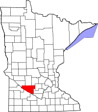 | |
| Townships | ||
| Unincorporated community | ||
| Ghost town | ||
| Footnotes | ‡This populated place also has portions in an adjacent county or counties | |
Municipalities and communities of Yellow Medicine County, Minnesota, United States | ||
|---|---|---|
| Cities |  | |
| Townships | ||
| Indian reservation | ||
| Unincorporated community | ||
| Footnotes | ‡This populated place also has portions in an adjacent county or counties | |
Coordinates: 44°48′36″N 95°32′44″W / 44.81000°N 95.54556°W