Granada Hills, Los Angeles
| Granada Hills | |
|---|---|
| Neighborhood of Los Angeles | |
|
A welcome sign at Chatsworth Street and Zelzah Avenue | |
| Motto: "The Valley's Most Neighborly Town"[1] | |
 Boundaries of Granada Hills as drawn by the Los Angeles Times | |
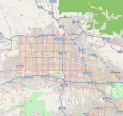 Granada Hills Location within Los Angeles/San Fernando Valley | |
| Coordinates: 34°17′N 118°30′W / 34.283°N 118.500°W | |
| Elevation | 292 m (959 ft) |
| Time zone | PST (UTC-8) |
| • Summer (DST) | PDT (UTC-7) |
| Area code | 818 |

Granada Hills is a lightly populated, highly diverse and high-income neighborhood. It is a suburban residential community in the San Fernando Valley portion of the city of Los Angeles.
There is an active sports program and a range of city recreation centers. The neighborhood has fourteen public and seven private schools.
History
The community began as dairy farm and orchard known as the Sunshine Ranch which grew apricots, oranges, walnuts and beans. Vestiges of former citrus groves can still be seen in orange, lemon or grapefruit trees in many residential yards. In 1916, the San Fernando Valley's first oil well was drilled in what is now Granada Hills. The oil well was located at the northern tip of Zelzah Avenue. Granada Hills was founded in 1926 as "Granada;" the "Hills" portion of the name was added 15 years later.
Geography
Granada Hills is located at the foothills of the Santa Susana Mountains, north of the North Hills, Northridge, west of Mission Hills and Sylmar, and east of the Porter Ranch neighborhoods of Los Angeles. The Ronald Reagan Freeway–Route 118 runs along its southern side.
Demographics
The 2000 U.S. census counted 50,535 residents in the 15.11-square neighborhood—or 3,344 people per square mile. In 2008, the city estimated that the population had increased to 53,998. In 2000 the median age for residents was 37,[2]
The neighborhood is ethnically diverse and includes whites, 55.5%; Latinos, 20.6%; Asians, 16.3%; blacks, 3.4; and others, 4.2%. Korea (16.0%) and Mexico (13.8%) were the most common places of birth for 29.2% of the residents who were born abroad[2]
The median yearly household income in 2008 was $83,911. Renters occupied 26.4% of the housing stock. The average household size of 2.9 people was considered average for Los Angeles. The percentages of married men (60.4%) and women (58.5%) were among the county's highest. There were 4,032 veterans, or 10.5% of the population, a high proportion compared to the rest of the city.[2]
Arts and culture
Architecture

Granada Hills is composed mostly of Mid-Century modern architecture. Of note is the "Balboa Highlands" tract built by iconic developer Joseph Eichler.[3] Many of these homes, which are North of Rinaldi/West of Balboa, have been featured in movies, commercials, magazine pictorials and appear in books about Eichler or mid-century architecture.
Historical landmarks

White Oak Avenue, between San Fernando Mission and San Jose Street was declared a Los Angeles Historic-Cultural Monument on August 3, 1966 for the 101 Deodar Cedar trees that line the street. The trees are native to the Himalayas and appreciated for their size, beauty and timber. White Oak Avenue trees was used as the back-drop in the flying bicycles scene in the 1982 film "E.T. the Extra-Terrestrial".[4]
Sports
Granada Hills Charter High School's stadium, the John Elway Stadium (named after the quarterback, an alumnus), is the home of the Los Angeles Rampage women's soccer team and the former home of the San Fernando Valley Quakes.
In 1963, the Granada Hills Little League won the Little League World Championship in baseball.[5]
Parks and recreation
O'Melveny Park, the second largest park in Los Angeles, consists of a large undeveloped area and a much smaller developed section with several dozen citrus trees, a small intermittent stream, and grass and picnic areas. This 672-acre (2.72 km2) park includes hiking trails and fire roads, including a grassy promontory from which a view of the northeastern portion of the San Fernando Valley may be seen.[6][7] Mission Point and its environs are popular mountain biking and hiking areas. The view from the top of Mission Point (called "Mission Peak" by many residents), the highest point in Granada Hills, is striking, taking in most of the San Fernando Valley. In clear weather, one can see the Pacific Ocean and Downtown Los Angeles. The area around the peak is home to deer, golden eagle, bobcats, mountain lions, raccoons, and coyotes.[8][9]
The Granada Hills Recreation Center (also known as Petit Park) is located at 16730 Chatsworth Street, at Petit Avenue. It features an Auditorium, four Baseball Diamonds that are lighted, Indoor and outdoor Basketball Courts, two Children's Play Area, an Indoor Gym, many Picnic Tables, Tennis Courts that are lighted, Classrooms, and a Dance Room. The sports it offers during the fall season is, Youth Soccer, Youth Baseball, Basketball for Adults and Youth, Youth Flag Football, Gymnastics, Youth Softball, Sports Clinics. Other programs included is Arts & Crafts, Dance classes, Kick Boxing, Music, Pre-School, Spring Day Camp, Summer Day Camp, Winter Day Camp. Hours of operation for this park are Monday-Friday 9am-9pm and Saturday 9:00-5:00pm. It is closed on Sundays and on Holidays. .[10]
Zelzah Park, an unstaffed park, has a bridle path, a children's play area, and picnic tables.[11]
Government
Local
- City Council
Los Angeles City Council District 12 encompasses Granada Hills, with councilmember Mitchell Englander serving..
- Neighborhood Councils
Granada Hills is served by two Neighborhood Councils:
- Granada Hills North Neighborhood Council — Representing the area bounded by Los Angeles County line to the north, Aliso Canyon to the west (west of Zelzah), Interstate 5 and Interstate 405 to the east and California 118 to the south. Formed in fall, 2002.[12]
- Granada Hills South Neighborhood Council — Representing the area bounded by California 118 to the north, Lindsey and Aliso Canyon to the west, Interstate 405 to the east and Devonshire Street to the south.[13]
County, state and federal
Granada Hills is in California's 30th congressional district as of 2013 and represented by Democrat Brad Sherman.[14] It was in the 38th State Assembly district, and the 20th State Senate district until the 2014 redistricting.[15]
Education
Thirty-two percent of Granada Hills residents aged 25 and older have earned a four-year degree by 2000, an average percentage for the city.[2]
Schools

.jpg)
Schools within the Granada Hills boundaries are:[16]
Public
- John F. Kennedy High School, 11254 Gothic Avenue
- North Valley Charter Academy, 16651-A Rinaldi Street
- Granada Hills Charter High School, 10535 Zelzah Avenue
- Valley Academy of Arts and Sciences, 10445 Balboa Boulevard
- George K. Porter Middle School, 15960 Kingsbury Street
- Robert Frost Middle School, 12314 Bradford Place
- Patrick Henry Middle School, 17340 San Jose Street
- El Oro Way Elementary School, 12230 El Oro Way
- Knollwood Elementary School, 11822 Gerald Avenue
- Danube Avenue Elementary School, 11220 Danube Avenue
- Jane Addams Continuation School, 16341 Donmetz Street
- Tulsa Street Elementary School, 10900 Hayvenhurst Avenue
- Haskell Elementary School, 15850 Tulsa Street
- Van Gogh Street Elementary School, 17160 Van Gogh Street
- Granada Elementary Community Charter School, 17170 Tribune Street
- Rinaldi Adult Center (Adult School), 17540 Rinaldi Street #6 [17]
Private
- St. Euphrasia School, Elementary, 17637 Mayerling Street
- Jewish Educational Trade School, 16601 Rinaldi Street
- Our Savior's First Lutheran School, Elementary, 16603 San Fernando Mission Boulevard
- Granada Hills Baptist Elementary School, 10949 Zelzah Avenue
- De La Salle Elementary School, 16535 Chatsworth Street
- Abraham Joshua Heschel Day School, Elementary, 17701 Devonshire Street
- Pinecrest/Northridge School, Elementary, 17081 Devonshire
- Heritage (Formerly Hillcrest) Christian School - 17531 Rinaldi Street (K - 8), 10949 Zelzah Street (Preschool)
- Heritage (formerly Los Angeles Baptist High School)-9825 Woodley Ave
- St. Nicholas School, 9501 Balboa Blvd, Northridge, CA 91325 (Pre-School - 8)
Infrastructure
Public services
Los Angeles Fire Department Stations 18 (Knollwood/Granada Hills) and 87 (Granada Hills) are in the area.
Granada Hills is served by the Los Angeles Police Department Devonshire Community Police Station.[18]
Health care
The Los Angeles County Department of Health Services operates the Pacoima Health Center in Pacoima, serving Granada Hills.[19]
Postal service
The United States Postal Service Granada Hills Post Office is located at 18039 Chatsworth Street.[20]
Libraries
Los Angeles Public Library operates the Granada Hills Branch.
Notable people
- Hal Bernson, Los Angeles City Council member who fought the Sunshine Canyon project in the 1980s and 1990s[21]
- Ryan Braun, professional baseball player, Granada Hills High School alumnus[22]
- Jeff Bregel, professional football player, John F. Kennedy High School alumnus[23]
- Chao-Li Chi, actor[24]
- John Elway, Denver Broncos quarterback[25]
- Cuba Gooding, Jr, actor, Kennedy High School alumnus[26]
- Stuart Gray, professional basketball player, John F. Kennedy High School alumnus[27]
- Maurice Greene, track athlete[28]
- Ashley Judd, actress, was born in Granada Hills.[29]
- Khalil Paden, football player
- Jim Rodnunsky, technician, inventor of the Cablecam system.[30][31]
- C.J. Sanders, football player at the University of Notre Dame[32]
- Jeff Serr, radio personality, voice actor
- Frank Wilcox, actor and "honorary mayor" of Granada Hills in the 1960s.[33]
See also
References
- ↑ "Granada Hills Chamber of Commerce". Granada Hills Chamber of Commerce. Retrieved September 6, 2012.
- 1 2 3 4 "Granada Hills," Mapping L.A., Los Angeles Times
- ↑ "Eichler Homes of Balboa Highlands - Welcome". Balboa Highlands Neighborhood Website. Retrieved 2014-07-03.
- ↑ "No. 41 - 114 Deodar Trees". Big Orange Landmarks. 2007-07-04. Retrieved 2014-08-03.
- ↑ "Little League Baseball: Past Champions". Littleleague.org. Retrieved January 25, 2011.
- ↑ "The Quiet Majesty of O'Melveny Park". The Trust for Public Land.
- ↑ "O'Melveny Park". Santa Monica Mountains Conservancy.
- ↑ "Mission Point: Mission Point Trail". Trails.com. Retrieved July 24, 2010.
- ↑ "Neon Way – Granada Hills – Los Angeles County". socalmtb.com. Retrieved July 24, 2010.
- ↑ "Granada Hills Recreation Center". City of Los Angeles Department of Recreation and Parks. Retrieved July 24, 2010.
- ↑ "Zelzah Park". City of Los Angeles Department of Recreation and Parks. Retrieved July 24, 2010.
- ↑ Granada Hills North Neighborhood Council
- ↑ Granada Hills South Neighborhood Council
- ↑ "California's 30th Congressional District - Representatives & District Map - GovTrack.us". Retrieved April 1, 2013.
- ↑ "Project Vote Smart information for 91344". Votesmart.org. Retrieved January 25, 2011.
- ↑ "Granada Hills: Schools," Mapping L.A., Los Angeles Times
- ↑ North Valley Service Area - Rinaldi Adult Center
- ↑ "Citywide Division Map". Los Angeles Police Department. Retrieved March 7, 2010.
- ↑ "Pacoima Health Center." Los Angeles County Department of Health Services. Retrieved on March 17, 2010.
- ↑ "Post Office Location – GRANADA HILLS." United States Postal Service. Retrieved on December 6, 2008.
- ↑ Gabe Fuentes, "Official Orders Dump to Make Changes, but Won't Close It," Los Angeles Times, September 2, 1988
- ↑ Mulhern, Tom, "Brewers: Braun's start a smashing success", Wisconsin State Journal, July 21, 2007
- ↑ Elling, Steve, "FOOTBALL : 49ers' Bregel Gives Money to Hospital, USC and Old Neighborhood, "Los Angeles Times", July 24, 1987
- ↑ "Chao-Li Chi obituary". Los Angeles Times. 2010-10-24.
- ↑ Reilly, Rick (May 10, 1983). "Elway's 'just one of the boys'". Eugene Register-Guard. (Denver Post). p. 1C.
- ↑ Cuba Gooding, Jr at the Internet Movie Database
- ↑ EISENHAMMER, FRED, "NBA Finds It Hard to Get Gray Out", "Los Angeles Times", January 7, 1990.
- ↑ http://www.adidas.com/athlete/Maurice_Greene.asp
- ↑ Ashley Judd at the Internet Movie Database
- ↑ Farmer, Sam (2011-06-16). "Jim Rodnunsky dies at 54; developer of Cablecam system used in sporting events, Hollywood films". Variety. Retrieved 2011-07-05.
- ↑ "Cablecam developer Jim Rodnunsky dies". Variety. 2011-06-16. Retrieved 2011-07-05.
- ↑ "C.J. Sanders". UND.com. Retrieved July 29, 2016.
- ↑ "Biography of Frank Wilcox". Internet Movie Data Base. Retrieved February 17, 2013.
External links
| Wikimedia Commons has media related to Granada Hills, Los Angeles. |
- Granada Hills Chamber of Commerce
- Granada Hills North Neighborhood Council
- Granada Hills South Neighborhood Council
- Old Granada Hills Residents' Group
- Granada Hills History Project
- GigaGranadaHills.com, The Granada Hills Blog
- Granada Hills crime map and statistics
Coordinates: 34°17′N 118°30′W / 34.28°N 118.5°W
| Districts and neighborhoods |
|  |
|---|---|---|
| Points of interest | ||
| Neighboring cities and communities | ||
| Topics |  | |
|---|---|---|
| Government | ||