Granada, Meta
For other uses, see Granada (disambiguation).
| Granada, Meta | |||
|---|---|---|---|
| Municipality and town | |||
 | |||
| |||
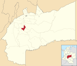 Location of the municipality and town of Granada, Meta in the Meta Department of Colombia. | |||
 Granada, Meta Location in Colombia | |||
| Coordinates: 3°32′49″N 73°42′36″W / 3.54694°N 73.71000°W | |||
| Country |
| ||
| Department | Meta Department | ||
| Area | |||
| • Total | 350 km2 (140 sq mi) | ||
| Elevation | 372 m (1,220 ft) | ||
| Population (2012) | |||
| • Total | 48,205 | ||
| • Density | 140/km2 (360/sq mi) | ||
| Demonym(s) | Granadino | ||
| Time zone | Colombia Standard Time (UTC-5) | ||
| Area code(s) | 57 + 8 | ||
| Website | Official website (Spanish) | ||

.svg.png)
Granada is a town and municipality in the Meta Department, Colombia. The municipality area is 350 km² and number of inhabitants 50 837. The municipality is located between 3° 26" latitude north and 73° 43" longitude west and between 372 og 410 above sea level. The daily mean air temperature varies between 24°C and 25.6°C. Annual precipitation is between 2 400 og 2 800 mm. The town is connected to Santa Fé de Bogotá along a 180 km road and 80 km from the regional capital Villavicencio.
Coordinates: 3°20′00″N 73°50′00″W / 3.33333°N 73.8333°W
This article is issued from Wikipedia - version of the 3/30/2014. The text is available under the Creative Commons Attribution/Share Alike but additional terms may apply for the media files.