Gothenburg tram network
 | |||
|
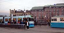
A tram running at Brunnsparken in central Gothenburg. | |||
| Overview | |||
|---|---|---|---|
| Owner | Gothenburg Municipality | ||
| Locale |
Gothenburg Mölndal, Sweden | ||
| Transit type | Tram | ||
| Number of lines | 15 | ||
| Number of stations | 131 | ||
| Daily ridership | 285,112 | ||
| Operation | |||
| Began operation | 1879 | ||
| Operator(s) | Göteborgs Spårvägar | ||
| Host railroads | Västtrafik | ||
| Number of vehicles | 200 | ||
| Technical | |||
| System length | 95 km (59.0 mi) of double track | ||
| Track gauge |
1,435 mm (4 ft 8 1⁄2 in) (standard gauge) | ||
| Average speed | 22.7 km/h (14.1 mph) | ||
| Top speed |
60 km/h (37 mph) allowed (max 80 km/h (50 mph)) | ||
| |||

The Gothenburg tram network (Swedish: Göteborgs spårvägar) is part of the public transport system organised by Göteborgs Spårvägar, controlled by Västtrafik in the Swedish city of Gothenburg. The system's approximately 160 kilometres (99 mi) of single track — making it the largest tram network in Sweden[1] — is used by around 200 trams as of 2006, which serve twelve day-time and five night-time lines with a combined line length of 190 km. These figures are expected to increase when the second stage of Kringen (short for Kollektivringen, the public transport ring) is finished. The trams perform about 2,000 trips and cover 30,000 km per day. In 2007, 100.5 million journeys were made (with changes counting as a new journey).[2]
History
The first tram line in Gothenburg was started in 1879 by the English company Gothenburg Tramway Ltd. This was a horse-drawn tramway, which stretched from Brunnsparken to Stigbergsliden. The city of Gothenburg bought the tramway in 1900, and introduced electrically powered trams only two years later, when Sigfrid Edström led the electrification of the trams. During the next 40 years, the tram system was heavily expanded, reaching outside the city borders by 1907, and Hisingen in 1940.
In the 1960s, plans for converting the tram system to an underground rapid transit system were created, and the new tram sections to the Tynnered, Angered, Bergsjön and Länsmansgården suburbs were built free from level crossings and partly in tunnels to make a future conversion to underground standards easier. However, after further investigation, it was concluded that it would be too expensive to dig the necessary tunnels under the city centre, as the foundation of the city is partially made up of clay.

When Sweden's switch to right-hand traffic in 1967 made existing unidirectional trams obsolete, Gothenburg was one of only two cities in Sweden to maintain its city-centre tramway, the other such network to survive being the Norrköping tramway.
The expansion of the net through the Kringen is gradually and step by step creating a tramway ring around the city centre. In 1999 the first step was started, which most notably included the 1050 m long Chalmers tunnel which was opened for traffic in 2002, connecting the Chalmers station with the Korsvägen hub. The second and third steps are currently in the planning stage.

Since 2010, the previously used magnetic stripe cards have been replaced with RFID cards. Ticket machines taking coins and credit cards have also been installed on the trams, along with a text message system where tickets may be purchased with mobile phones.[3]
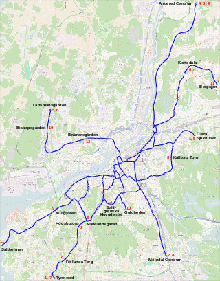
Lines

| Line | Stretch | Length | Stops | Travel time[Note 1] | Average speed[Note 1] | Passengers/day[Note 2] |
|---|---|---|---|---|---|---|
| Tynnered–Östra Sjukhuset | 15.6 km | 33 | 47/49 min | 19.1 km/h | 32 500 | |
| Högsbotorp–Mölndal (over Ullevi) | 12.9 km | 27 | 40 min[Note 3] | |||
| Marklandsgatan–Kålltorp (over Brunnsparken) | 12.7 km | 30 | 44/45 min | 16.9 km/h | 32 400 | |
| Mölndal–Angered (over Brunnsparken) | 19.3 km | 21 | 41/40 min | 28.2 km/h | 27 400 | |
| Östra Sjukhuset–Länsmansgården (over Korsvägen) | 13.8 km | 29 | 39/38 min | 21.2 km/h | 25 500 | |
| Länsmansgården–Kortedala (over Järntorget-Korsvägen) | 24.6 km | 46 | 71/71 min | 20.7 km/h | 43 400 | |
| Tynnered–Bergsjön | 21.1 km | 35 | 54/55 min | 23.0 km/h | 35 900 | |
| Frölunda–Angered (over Korsvägen) | 21.3 km | 25 | 46/47 min | 27.2 km/h | 19 600 | |
| Kungssten–Angered (over Brunnsparken) | 19.0 km | 21 | 43/43 min | 26.5 km/h | 25 600 | |
| Guldheden–Eketrägatan/Biskopsgården | 8.8 km[Note 4] | 17/23 | 24/31 / 25/32 min | 21.7 km/h[Note 5] | 15 600 | |
| Saltholmen–Bergsjön | 21.8 km | 38 | 58/58 min | 22.6 km/h | 38 000 | |
| Planned tram line. Will have a stretch of "Norra älvstranden". | ||||||
| Sahlgrenska–Brämaregården (over Korsvägen) | 7.9 km | 13 | 23 min[Note 3] | |||
| Disused tram line since 2006. Had the route "Centralstationen - Krokslätt" (Central Station - Krokslätt). | ||||||
| "Liseberg Line" operated by heritage trams. Has the route Central Station – Liseberg – (Sankt Sigfrids plan) (3.5 km; 8 stops). | ||||||
| Instead of route number on cars used for driver training (when not with passengers) and at special events. One example is the European Athletics Championships in August 2006 when the line sign was "Teams Tram" for the European Championship participant. | ||||||
Most tram lines pass through Brunnsparken, which is effectively the central hub of public transport in Gothenburg. The exceptions are lines 8 and 13. The Central Station is also a major stop, especially because it is the nearest stop not only for train passengers but also passengers coming from the neighbouring Nils Ericson Terminal, where coaches, airport buses to Landvetter Airport and City Airport and regional buses stop. Korsvägen is another major stop, where lines 6 and 8 meet lines going into the city centre and out to Mölndal. Most tram lines are on the south side of the river, but lines 5, 6, 10 and 13 cross the Göta älv bridge to the north side.
Rolling stock

The types of tramcars currently running in Gothenburg are:
- M28, ASJL 1965–1967, 701–711, 713–763, 766, 767
- M29, Hägglund 1969–1972, 801–838, 840–857, 859, 860
- M31 (previously M21 ASEA 1984–1992, rebuilt with low-floor middle articulation), ASEA/MGB 1998–2003, 300–305, 307-380
- M32 Sirio, AnsaldoBreda 2005–2013, (as of January 2016) 401-465
In 2013 work with deciding new tram stocks began. By April 2016, it was announced that a minimum 40 trams of the new model M33 had been ordered from Bombardier Transportation Sweden AB/Vossloh Kiepe GmbH for delivery by year 2019. [4]
There is a fleet of heritage trams used in the network. One of the oldest trams, M1 15, which was built in 1902, is preserved in operational condition.
See also
Notes
- 1 2 Measured during rush hours, first number along stretch as written, second number in opposite direction.
- ↑ Measured weekdays in November 2005.
- 1 2 Timetable value, not actually measured
- ↑ From Guldheden to Eketrägatan.
- ↑ From Guldheden to Biskopsgården.
References
Inline citations
- ↑ Martin Rudolphi. "A study of the possibility and the potential effects of a tramway tunnel construction in Gothenburg City" (pdf) (Masters Thesis). Chalmers University of Technology. p. 8. Retrieved 20 April 2013.
- ↑ Antalet delresor med spårvagn passerade 100 miljoner
- ↑ Färdbevis och priser
- ↑ "Avtalet klart för nya spårvagnsleveranser till Göteborg - Göteborgs Spårvägar". Göteborgs Spårvägar (in Swedish). 2016-10-11. Retrieved 2016-11-10.
Other references
- Engberg, Patrik (n.d.). Vagnhallen.com. Retrieved 19 Mar., 2006.
- Göteborgs Spårvägar (n.d.). Göteborgs Spårvägar. Retrieved 19 Mar., 2006
External links
| Wikimedia Commons has media related to Trams in Göteborg. |
- Göteborgs Spårvägar - Transport company (Swedish)
- Västtrafik - Transport authority (Swedish)/(English)
- Official line map (Västtrafik) (Swedish)/(English)
- Vagnhallen.com (Swedish)
- Urban Transport Technology - Gothenburg (English)
- Tram Travels: Göteborgs Spårvägar (GS)

| Commuter rail |   | ||||||
|---|---|---|---|---|---|---|---|
| Semi commuter rail |
| ||||||
| Rapid transit | |||||||
| Trams/Light rail | |||||||
| Trolleybuses |
| ||||||
| Ferries |
| ||||||