Gostivar
| Gostivar Гостивар | |||
|---|---|---|---|
| Gostivari | |||
|
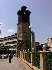
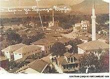
Collage of Gostivar | |||
| |||
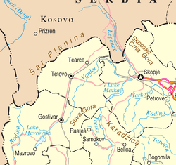 Location in Northwestern Macedonia. | |||
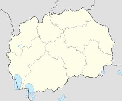 Gostivar Location within Macedonia | |||
| Coordinates: 41°48′N 20°55′E / 41.800°N 20.917°E | |||
| Country |
| ||
| Municipality | Gostivar Municipality | ||
| Government | |||
| • Mayor | Nevzat Bejta (DUI) | ||
| Area | |||
| • Total | 1.341 km2 (0.518 sq mi) | ||
| Population (2002) | |||
| • Total | 35,847 | ||
| Time zone | CET (UTC+1) | ||
| • Summer (DST) | CEST (UTC+2) | ||
| Climate | Cfb | ||
| Website | gostivari.gov.mk | ||


Gostivar (Macedonian: Гостивар [ˈɡɔstivar]; Albanian: Gostivar/Gostivari; Turkish: Gostivar), is a city in the Republic of Macedonia, located in the upper Polog valley region. It is one of the largest municipalities in the country with a population of 81,042,[1] and the town also covers 1.341 square kilometres (331 acres). Gostivar has good road and railway connections with the other cities in the region, such as Tetovo, Skopje, Kičevo, Ohrid, and Debar. A modern freeway was built in 1995, from Gostivar to Tetovo, 24 km (15 mi) long. Gostivar is the seat of Gostivar Municipality.
Geography
Gostivar is situated on the foothills of one of the most important mountains in the region: the Šar Mountains. Near to Gostivar is the village of Vrutok, where the Vardar river begins at an altitude of 683 meters (2,241 ft) from the base of the Šar Mountains. Vardar River extends through Gostivar, cutting it in half, passes through the capital Skopje, goes through the country, enters Greece and finally reaches the Aegean Sea.
Demographics
According to the 2002 census, the city of Gostivar has a population of 35,847 inhabitants and the ethnic composition is the following:[2]
- Albanians, 16,890 (47.1%)
- Macedonians, 11,885 (33.2%)
- Turks, 4,559 (12.7%)
- Romas, 1,899 (5.3%)
- others, 614 (1.7%)
The most common mother tongues in the city were the following:
- Albanian, 16,877 (47.1%)
- Macedonian, 13,843 (38.6%)
- Turkish, 4,423 (12.3%)
- Romani, 301 (0.8%)
- Serbian, 124 (0.3%)
- others, 279 (0.7%)
The religious composition of the city was the following:
- Muslims, 23,686 (66.1%)
- Orthodox Christians, 11,865 (33.1%)
- others, 296 (0.8%)
| Ethnic group |
census 1948 | census 1953 | census 1961 | census 1971 | census 1981 | census 1994 | census 2002 | |||||||
|---|---|---|---|---|---|---|---|---|---|---|---|---|---|---|
| Number | % | Number | % | Number | % | Number | % | Number | % | Number | % | Number | % | |
| Macedonians | .. | .. | 2,637 | 27.7 | 5,092 | 39.8 | 8,109 | 41.7 | 10,127 | 36.5 | 12,084 | 36.7 | 11,885 | 33.2 |
| Albanians | .. | .. | 4,313 | 45.4 | 2,904 | 22.7 | 6,044 | 31.1 | 10,791 | 38.9 | 14,128 | 42.3 | 16,890 | 47.1 |
| Turks | .. | .. | 1,924 | 20.2 | 4,349 | 34.0 | 4,449 | 22.9 | 4,378 | 15.8 | 4,475 | 13.6 | 4,559 | 12.7 |
| Romani | .. | .. | 353 | 3.7 | 0 | 0.0 | 219 | 1.1 | 1254 | 4.5 | 1,609 | 4.9 | 1,899 | 5.3 |
| Vlachs | .. | .. | 11 | 0.1 | 0 | 0.0 | 0 | 0.0 | 6 | 0.0 | 11 | 0.0 | 15 | 0.0 |
| Serbs | .. | .. | 133 | 1.4 | 249 | 2.0 | 254 | 1.3 | 233 | 0.9 | 233 | 0.7 | 146 | 0.4 |
| Bosnians | .. | .. | 0 | 0.0 | 0 | 0.0 | 0 | 0.0 | 0 | 0.0 | 0 | 0.0 | 34 | 0.1 |
| Others | .. | .. | 138 | 1.4 | 193 | 1.5 | 392 | 2.0 | 947 | 3.4 | 388 | 1.2 | 419 | 1.2 |
| Total | 7,832 | 9,509 | 12,787 | 19,467 | 27,726 | 32,926 | 35,847 | |||||||
History


It is known that there was a town called Draudak (built in 170BC) near or on the current place of Gostivar.

Early mentions of the town was made by the Roman historian Livy. He records how during the Third Macedonian War the King of Macedon Perseus at the head of 10000 men, after taking Uskana (Kicevo), attacked Drau-Dak, today Gostivar.
In the late 19th and early 20th century, Gostivar was part of the Kosovo Vilayet of the Ottoman Empire.
From 1929 to 1941, Gostivar was part of the Vardar Banovina of the Kingdom of Yugoslavia.
Economy
Gostivar is a merchant city. From the second half of the 19th century, many merchants started moving in and opening stores. There is also a market day, Tuesday. Merchants from Kruševo, Kičevo, Tetovo and Veles were the founders of the Gostivar merchant centre at that time. But today they have become electricians, mechanics workers. Today Gostivar is a modern city.
An important fact is that the 20,000 Expatriate citizens who are a key source of income in the municipality economy. It is calculated that each year between June and August, approximately 500,000 euros are brought into the city when they return.
In May 2015 the company announced that it will open a new automotive plant in Gostivar in the summer of 2015. This is Lear's first facility in Macedonia.[4]
Tourism
Leaving Gostivar on the way to Ohrid, the village Vrutok has the gorge of the biggest river in Macedonia, Vardar, which is 388 km (241 mi) long and flows into the Aegean Sea, at Thessaloniki. Gostivar is one of the biggest settlements in the Polog valley. The Polog valley can be observed from the high lands of Mavrovo and Galičnik, seeing the villages scattered through the valley like some kind of beautiful mosaic.
Some 26 km (16 mi) from Gostivar is located one of the best ski resorts in Macedonia: "Zare Lazarevski" in the Mavrovo National Park. Mavrovo is an interesting tourist attraction with unique natural beauties. This tourist centre is believed to be one of the most beautiful tourist attractions in Macedonia. It is a place of many natural beauties, magnificent vistas, a crystal clear lake, high mountain hills from where you can see panoramas of Bistra and its nearby village suburbs. Mavrovo attracts tourists during all seasons, but it is more attractive in winter when it is all covered with deep snow. This mountain is very rich with flora and fauna. The whole tourist complex manages with 1200 beds and over 1000 villas, with many hotels, restaurants and shops. The Mavrovo region hosts ski tournaments and other sport recreations. The peaks on the northern part of the Bistra mountain: Rusino Brdo, Sultanica and Sandaktas, have good conditions for winter sport activities. The popularity of Mavrovo is growing every year with the attraction of many tourists.
The Šar Mountain is one of the most important Alpine mountain ranges in Macedonia together with neighbouring Mount Korab and Bistra mountains. The range is 80 km (50 mi) long and 12 km (7 mi) wide and is covered with snow from November till March or April every year. Its highest peak, Titov Vrv, is situated on 2,760 meters (9,055 ft) above sea level. The picturesque village of Pozarane is one of the most famous and most beautiful in the region.
From the diverse fauna, the Šarplaninac dog is worth mentioning, as it has earned a fine reputation among pet dog lovers. These dogs are used by the sheep-herders of Šar Mountain (Šar Planina in Serbian and Macedonian), to guide and protect their sheep herds. Bears, wild boar and deer exist in these lands. Due to its rich vegetation and wildlife, as well as its preserved and unpolluted environment, it represents a real mecca for tourist resorts and sports facilities, where medical herbs can be picked, and even hunt activities arranged.
At summer time, Šar Mountain can be described as an ocean of grass. In fact, Šar Mountain is considered the largest compact area covered with pastures on the European Continent. This provides excellent opportunities for animal husbandry. High quality dairy products, mainly cheese and feta cheese, are made in the many sheepfolds on Šar and the adjacent mountains. The best known kinds of feta cheese are Shara and Galicnik. The Šar Mountain, along with the adjacent mountains, is rich in wide-ranging vegetation, which provides possibilities to gather medical herbs and to produce healthy food.
Located in the northwestern part of Macedonia, Popova Shapka is one of the most popular winter ski resorts in the country. It is situated on the beautiful Šar Mountain, 1,780 meters (5,840 ft) above the sea level, just 35 kilometres (22 mi) from the capital Skopje. Popova Shapka offers excellent ski environment and hotel accommodations. Visitors not only from the Republic of Macedonia, but also from many other countries, return season after season here to relax, have fun, and experience adventure. Popova Shapka has been a host to both the European and Balkan Ski Championships. Not far from the resort, there are many small picturesquely glacial lakes scattered around on the mountain. There are two ways to get to Popova Shapka: by car, and by rope-railway with a starting location in Tetovo. The rope-railway is 6 km (4 mi) long and it takes about 36 minutes to reach the top.
Notable people
References
- ↑ 2002 Census results
- ↑ Macedonian census, language and religion
- ↑ Censuses of population 1948 - 2002
- ↑ "Lear Corp. (LEA) to Open Automotive Plant in Macedonia" (Press release). Nasdaq. May 19, 2015.
External links
Cities and towns of Republic of Macedonia by population | ||
|---|---|---|
| 50,000+ |  | |
| 10,000+ | ||
| 2,000+ | ||
Coordinates: 41°48′N 20°55′E / 41.800°N 20.917°E