Gorman, Maryland
| Gorman | |
|---|---|
| Census-designated place | |
  Location within the state of Maryland | |
| Coordinates: 39°17′43″N 79°20′47″W / 39.29528°N 79.34639°WCoordinates: 39°17′43″N 79°20′47″W / 39.29528°N 79.34639°W | |
| Country | United States |
| State | Maryland |
| County | Garrett |
| Population (2000) | |
| • Total | 106 |
| Time zone | Eastern (EST) (UTC-5) |
| • Summer (DST) | EDT (UTC-4) |

The towns of Bayard, Gorman, and Gormania on a 1900 USGS topographical map.
Gorman is a census-designated place (CDP) along the North Branch Potomac River in southern Garrett County, Maryland. According to the census in 2010, Gorman's population is 106. Gorman lies on Gorman Road (Maryland Route 560) off the Northwestern Turnpike (U.S. Route 50), which crosses the North Branch into Gormania, West Virginia via Gormania Bridge. Like Gormania, the town is named for United States Senator from Maryland, Arthur P. Gorman (March 11, 1839 – June 4, 1906).
External links
Municipalities and communities of Garrett County, Maryland, United States | ||
|---|---|---|
| Towns | 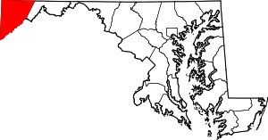 | |
| CDPs | ||
| Unincorporated communities | ||
| Ghost town | ||
| Footnotes | ‡This populated place also has portions in an adjacent county or counties | |
This article is issued from Wikipedia - version of the 10/29/2016. The text is available under the Creative Commons Attribution/Share Alike but additional terms may apply for the media files.