Gober, Texas
| Gober, Texas | |
|---|---|
| Unincorporated community | |
 Gober  Gober Location within the state of Texas | |
| Coordinates: 33°28′8″N 96°5′19″W / 33.46889°N 96.08861°WCoordinates: 33°28′8″N 96°5′19″W / 33.46889°N 96.08861°W | |
| Country | United States |
| State | Texas |
| County | Fannin |
| Elevation | 650 ft (200 m) |
| Time zone | Central (CST) (UTC-6) |
| • Summer (DST) | CDT (UTC-5) |
| ZIP codes | 75443 |
| GNIS feature ID | 1381921 |
Gober is an unincorporated community in southeastern Fannin County, Texas, United States.[1] Its elevation is 650 feet (198 m).[2] Although Gober is unincorporated, it has a post office, with the ZIP code of 75443,[3] which first opened in 1879.[1]
Gober was established as "Grittersville" in the 1840s; the name was changed in 1885 to honor the builders of the community's first mill, who were named Gober. The community has declined somewhat from its high point in the 1930s; today, it lies at the junction of FM 68 and FM 271.[1]
References
- 1 2 3 Gober, Texas, Handbook of Texas Online, 2008-01-17. Accessed 2008-08-10.
- ↑ U.S. Geological Survey Geographic Names Information System: Gober, Texas
- ↑ Zip Code Lookup
External links
Municipalities and communities of Fannin County, Texas, United States | ||
|---|---|---|
| Cities | 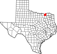 | |
| Towns | ||
| Unincorporated communities | ||
| Footnotes | ‡This populated place also has portions in an adjacent county or counties | |
www.leslieksmith.com
This article is issued from Wikipedia - version of the 11/12/2016. The text is available under the Creative Commons Attribution/Share Alike but additional terms may apply for the media files.