Glendo, Wyoming
| Glendo, Wyoming | |
|---|---|
| Town | |
|
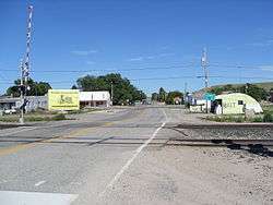
Looking east on A Street | |
| Motto: "Small in Number - Big in Heart" | |
 Location in Platte County and the state of Wyoming. | |
| Coordinates: 42°30′11″N 105°1′31″W / 42.50306°N 105.02528°WCoordinates: 42°30′11″N 105°1′31″W / 42.50306°N 105.02528°W | |
| Country | United States |
| State | Wyoming |
| County | Platte |
| Area[1] | |
| • Total | 0.53 sq mi (1.37 km2) |
| • Land | 0.53 sq mi (1.37 km2) |
| • Water | 0 sq mi (0 km2) |
| Elevation | 4,724 ft (1,440 m) |
| Population (2010)[2] | |
| • Total | 205 |
| • Estimate (2012[3]) | 205 |
| • Density | 386.8/sq mi (149.3/km2) |
| Time zone | Mountain (MST) (UTC-7) |
| • Summer (DST) | MDT (UTC-6) |
| ZIP code | 82213 |
| Area code(s) | 307 |
| FIPS code | 56-32290[4] |
| GNIS feature ID | 1588932[5] |
| Website | Glendo Wyoming |
Glendo is a town in Platte County, Wyoming, United States. The population was 205 at the 2010 census.
History
The town was incorporated in 1922. The California Trail, Oregon Trail and Mormon Trail passed south of Glendo.[6] The Overland Stage Line also passed south of Glendo.[7]
It was in a cabin near the town that William L. Carlisle, one of America's last train robbers, was captured in December 1919 after a shoot-out with the posse pursuing him.[8]
Geography
Glendo is located at 42°30′11″N 105°1′31″W / 42.50306°N 105.02528°W (42.503175, -105.025180).[9]
According to the United States Census Bureau, the town has a total area of 0.53 square miles (1.37 km2), all of it land.[1]
Demographics
| Historical population | |||
|---|---|---|---|
| Census | Pop. | %± | |
| 1930 | 201 | — | |
| 1940 | 162 | −19.4% | |
| 1950 | 215 | 32.7% | |
| 1960 | 292 | 35.8% | |
| 1970 | 210 | −28.1% | |
| 1980 | 367 | 74.8% | |
| 1990 | 195 | −46.9% | |
| 2000 | 229 | 17.4% | |
| 2010 | 205 | −10.5% | |
| Est. 2015 | 200 | [10] | −2.4% |
2010 census
As of the census[2] of 2010, there were 205 people, 101 households, and 59 families residing in the town. The population density was 386.8 inhabitants per square mile (149.3/km2). There were 167 housing units at an average density of 315.1 per square mile (121.7/km2). The racial makeup of the town was 97.1% White, 1.0% Native American, 1.0% from other races, and 1.0% from two or more races. Hispanic or Latino of any race were 3.4% of the population.
There were 101 households of which 16.8% had children under the age of 18 living with them, 52.5% were married couples living together, 5.9% had a female householder with no husband present, and 41.6% were non-families. 37.6% of all households were made up of individuals and 15.8% had someone living alone who was 65 years of age or older. The average household size was 2.03 and the average family size was 2.68.
The median age in the town was 52.1 years. 17.1% of residents were under the age of 18; 2.9% were between the ages of 18 and 24; 14.6% were from 25 to 44; 40.9% were from 45 to 64; and 24.4% were 65 years of age or older. The gender makeup of the town was 48.8% male and 51.2% female.
2000 census
As of the census[4] of 2000, there were 229 people, 110 households, and 66 families residing in the town. The population density was 431.5 people per square mile (166.8/km²). There were 165 housing units at an average density of 310.9 per square mile (120.2/km²). The racial makeup of the town was 95.20% White, 0.44% Native American, 2.18% from other races, and 2.18% from two or more races. Hispanic or Latino of any race were 5.24% of the population.
There were 110 households out of which 16.4% had children under the age of 18 living with them, 52.7% were married couples living together, 4.5% had a female householder with no husband present, and 39.1% were non-families. 32.7% of all households were made up of individuals and 15.5% had someone living alone who was 65 years of age or older. The average household size was 2.08 and the average family size was 2.55.
In the town the population was spread out with 14.8% under the age of 18, 7.9% from 18 to 24, 21.4% from 25 to 44, 31.9% from 45 to 64, and 24.0% who were 65 years of age or older. The median age was 50 years. For every 100 females there were 100.9 males. For every 100 females age 18 and over, there were 105.3 males.
The median income for a household in the town was $24,531, and the median income for a family was $26,786. Males had a median income of $21,146 versus $15,000 for females. The per capita income for the town was $14,529. About 2.4% of families and 9.0% of the population were below the poverty line, including 7.1% of those under the age of eighteen and 2.7% of those sixty five or over.
Parks and recreation
Glendo State Park
Glendo is near Glendo State Park, one of several state recreation areas along the North Platte River in Wyoming. The park surrounds Glendo Reservoir, which is a popular location for water sports and fishing.[12]
Education
Public education in the town of Glendo is provided by Platte County School District #1. Glendo Schools, a K-12 campus, serves the town.[13]
References
- 1 2 "US Gazetteer files 2010". United States Census Bureau. Archived from the original on January 24, 2012. Retrieved 2012-12-14.
- 1 2 "American FactFinder". United States Census Bureau. Retrieved 2012-12-14.
- ↑ "Population Estimates". United States Census Bureau. Archived from the original on June 17, 2013. Retrieved 2013-06-01.
- 1 2 "American FactFinder". United States Census Bureau. Retrieved 2008-01-31.
- ↑ "US Board on Geographic Names". United States Geological Survey. 2007-10-25. Retrieved 2008-01-31.
- ↑ "Glendo, Wyoming". Town of Glendo. Retrieved July 18, 2012.
- ↑ "Glendo, Wyoming". Town of Glendo. Retrieved July 21, 2012.
- ↑ 'CARLISLE TAKEN AFTER A BATTLE; Posse Wounds Elusive Train Robber, at Bay in a Wyoming Cabin. WOUND MAY PROVE MORTAL Bandit, Shot Through the Lung. Says He Is Glad the Chase Is Ended.' - The New York Times December 2, 1919
- ↑ "US Gazetteer files: 2010, 2000, and 1990". United States Census Bureau. 2011-02-12. Retrieved 2011-04-23.
- ↑ "Annual Estimates of the Resident Population for Incorporated Places: April 1, 2010 to July 1, 2015". Retrieved July 2, 2016.
- ↑ "Census of Population and Housing". Census.gov. Archived from the original on May 11, 2015. Retrieved June 4, 2015.
- ↑ "Glendo State Park". Wyoming State Parks,
Historic Sites & Trails. Retrieved July 20, 2012. line feed character in
|publisher=at position 21 (help) - ↑ "Glendo Schools". Platte County School District #1. Retrieved July 20, 2012.
Municipalities and communities of Platte County, Wyoming, United States | ||
|---|---|---|
| Towns | 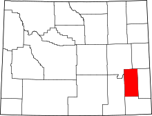 | |
| CDPs | ||
| Unincorporated communities | ||
| Ghost town | ||