Glandorf, Ohio
| Glandorf, Ohio | |
|---|---|
| Village | |
 Location of Glandorf, Ohio | |
 Location of Glandorf in Putnam County | |
| Coordinates: 41°1′49″N 84°4′45″W / 41.03028°N 84.07917°WCoordinates: 41°1′49″N 84°4′45″W / 41.03028°N 84.07917°W | |
| Country | United States |
| State | Ohio |
| County | Putnam |
| Area[1] | |
| • Total | 1.62 sq mi (4.20 km2) |
| • Land | 1.62 sq mi (4.20 km2) |
| • Water | 0 sq mi (0 km2) |
| Elevation[2] | 728 ft (222 m) |
| Population (2010)[3] | |
| • Total | 1,001 |
| • Estimate (2012[4]) | 1,003 |
| • Density | 617.9/sq mi (238.6/km2) |
| Time zone | Eastern (EST) (UTC-5) |
| • Summer (DST) | EDT (UTC-4) |
| ZIP code | 45848 |
| Area code(s) | 419 |
| FIPS code | 39-30282[5] |
| GNIS feature ID | 1064725[2] |
Glandorf is a village in Putnam County, Ohio, United States. The population was 1,001 at the 2010 census.
History
Glandorf was founded by Johann Wilhelm Horstmann and six other men from Glandorf, Germany in 1834.[6]:3–6 They embarked on the ship Columbus on September 7, 1833 in Amsterdam, landed November 6, 1833 in New York, and purchased some land in Putnam County in December.[7] Members of this group were Johann F. Kahle, Wilhelm Gülker, Christian Strop, F. Wischmann, Friedrich Bredeick and Mathias and Friedrich Bockrath. Kahle bought land at Greensburg approximately 5 miles to the west of Glandorf and named it Maria Camp. Horstmann's land was named Glandorf. Their wives and ten other families from Glandorf followed in 1834. This was just the beginning of further emigration from Germany to Ohio and other states of the USA. After his death on February 21, 1843, Horstmann left his land to the community.
In 1834 Horstmann built a log house to serve as church, school, and rectory. The new parish was placed under the patronage of St. John the Baptist. In 1835 the log house was replaced by a wooden church with a steeple, a bell and a pulpit from hallowed-out sycamore log. A brick church followed between 1846 and 1848. In 1878 the Neo-Gothic church St. John the Baptist was erected and consecrated on December 15.[6]:15 In 1992 a fire started in the sacristy of the church and the sacristy and its contents were a complete loss. The entire interior has to be repainted. A convent of the German sisters' order of the Society of the Precious Blood was founded in 1849. They cultivated the land which was originally owned by Horstmann and served as teachers. The convent was abandoned in 1917.[8]
 St. John the Baptist
 St. John the Baptist church with monument of Johann Wilhelm Horstmann
 Monument of Johann Wilhelm Horstmann
 Sesquicentennial Memorial 1834 - 1984
Geography
Glandorf is located at 41°1′49″N 84°4′45″W / 41.03028°N 84.07917°W (41.030355, -84.079109).[9]
According to the United States Census Bureau, the village has a total area of 1.62 square miles (4.20 km2), all land.[1]
Demographics
| Historical population | |||
|---|---|---|---|
| Census | Pop. | %± | |
| 1890 | 571 | — | |
| 1900 | 749 | 31.2% | |
| 1910 | 558 | −25.5% | |
| 1920 | 499 | −10.6% | |
| 1930 | 455 | −8.8% | |
| 1940 | 483 | 6.2% | |
| 1950 | 479 | −0.8% | |
| 1960 | 747 | 55.9% | |
| 1970 | 732 | −2.0% | |
| 1980 | 746 | 1.9% | |
| 1990 | 829 | 11.1% | |
| 2000 | 919 | 10.9% | |
| 2010 | 1,001 | 8.9% | |
| Est. 2015 | 1,006 | [10] | 0.5% |
96.2% spoke English and 3.8% German.[12]
2010 census
As of the census[3] of 2010, there were 1,001 people, 340 households, and 263 families residing in the village. The population density was 617.9 inhabitants per square mile (238.6/km2). There were 351 housing units at an average density of 216.7 per square mile (83.7/km2). The racial makeup of the village was 98.3% White, 0.8% Asian, 0.1% from other races, and 0.8% from two or more races. Hispanic or Latino of any race were 1.6% of the population.
There were 340 households of which 40.6% had children under the age of 18 living with them, 70.3% were married couples living together, 4.7% had a female householder with no husband present, 2.4% had a male householder with no wife present, and 22.6% were non-families. 20.3% of all households were made up of individuals and 10% had someone living alone who was 65 years of age or older. The average household size was 2.81 and the average family size was 3.30.
The median age in the village was 38.8 years. 28.6% of residents were under the age of 18; 5.9% were between the ages of 18 and 24; 24.1% were from 25 to 44; 25.6% were from 45 to 64; and 15.9% were 65 years of age or older. The gender makeup of the village was 47.3% male and 52.7% female.
2000 census
As of the census[5] of 2000, there were 919 people, 286 households, and 237 families residing in the village. The population density was 599.4 people per square mile (231.9/km²). There were 297 housing units at an average density of 193.7 per square mile (74.9/km²). The racial makeup of the village was 98.59% White, 0.11% Asian, 0.44% from other races, and 0.87% from two or more races. Hispanic or Latino of any race were 1.09% of the population.
There were 286 households out of which 43.7% had children under the age of 18 living with them, 74.8% were married couples living together, 4.5% had a female householder with no husband present, and 16.8% were non-families. 15.7% of all households were made up of individuals and 7.0% had someone living alone who was 65 years of age or older. The average household size was 2.93 and the average family size was 3.29.
In the village the population was spread out with 28.2% under the age of 18, 5.3% from 18 to 24, 29.3% from 25 to 44, 17.8% from 45 to 64, and 19.4% who were 65 years of age or older. The median age was 37 years. For every 100 females there were 93.5 males. For every 100 females age 18 and over, there were 88.0 males.
The median income for a household in the village was $52,083, and the median income for a family was $56,528. Males had a median income of $38,750 versus $25,500 for females. The per capita income for the village was $19,055. None of the families and 0.4% of the population were living below the poverty line, including no under eighteens and 3.1% of those over 64.
References
- 1 2 "US Gazetteer files 2010". United States Census Bureau. Retrieved 2013-01-06.
- 1 2 "US Board on Geographic Names". United States Geological Survey. 2007-10-25. Retrieved 2008-01-31.
- 1 2 "American FactFinder". United States Census Bureau. Retrieved 2013-01-06.
- ↑ "Population Estimates". United States Census Bureau. Retrieved 2013-06-17.
- 1 2 "American FactFinder". United States Census Bureau. Retrieved 2008-01-31.
- 1 2 Leach, Michael E. (2000). "Laborers in the Vineyard, Precious Blood Ministry in Glandorf, Putnam County, Ohio". The Hubbard Company.
- ↑ Hunsche, Friedrich E. (11 April 1968). "Glandorf in Nordamerika. Aus der Geschichte der Gemeinde und einiger Tochtergemeinden". Neue Osnabrücker Zeitung. p. 16.
- ↑ Kline, Nancy (2009-03-09). "Celebrating 175 years in Glandorf". PutnamVoice.com. Retrieved 2009-08-11.
- ↑ "US Gazetteer files: 2010, 2000, and 1990". United States Census Bureau. 2011-02-12. Retrieved 2011-04-23.
- ↑ "Annual Estimates of the Resident Population for Incorporated Places: April 1, 2010 to July 1, 2015". Retrieved July 2, 2016.
- ↑ "Census of Population and Housing". Census.gov. Retrieved June 4, 2015.
- ↑ http://www.mla.org/cgi-shl/docstudio/docs.pl?map_data_results
Municipalities and communities of Putnam County, Ohio, United States | ||
|---|---|---|
| Villages | 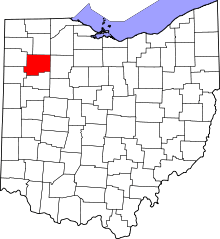 | |
| Townships | ||
| CDP | ||
| Unincorporated communities | ||
| Ghost towns | ||