Glacier, Washington
| Glacier, Washington | |
|---|---|
| CDP | |
 | |
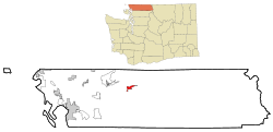 Location of Glacier, Washington | |
| Coordinates: 48°53′18″N 121°56′2″W / 48.88833°N 121.93389°W | |
| Country | United States |
| State | Washington |
| County | Whatcom |
| Area | |
| • Total | 3.0 sq mi (7.8 km2) |
| • Land | 3.0 sq mi (7.8 km2) |
| • Water | 0.0 sq mi (0.0 km2) |
| Elevation | 906 ft (276 m) |
| Population (2010) | |
| • Total | 211 |
| • Density | 29.9/sq mi (11.6/km2) |
| Time zone | Pacific (PST) (UTC-8) |
| • Summer (DST) | PDT (UTC-7) |
| ZIP code | 98244 |
| Area code | 360 |
| FIPS code | 53-26875[1] |
| GNIS feature ID | 1519971[2] |
| Highways |
|
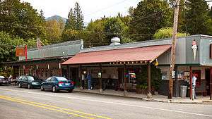
Glacier is a census-designated place in Whatcom County, Washington, United States. The population was 211 at the 2010 census.
Based on per capita income, Glacier ranks 522nd (last) of 522 areas in the state of Washington to be ranked. Glacier is hoping to change this with the opening of the Glacier Chamber of Commerce.
Glacier is the community closest to Mt. Baker (northernmost of the Cascade volcanoes), is within 10 air miles of Mt. Baker's summit and a 20-mile drive to the Mt. Baker Ski Area with awe-inspiring views of Mount Shuksan, one of the most photographed mountains in the world. It consists of a number of thriving businesses - including coffee shops, ski and snowboard shops, restaurants, a small grocery store, and a design company. The Glacier Public Service Center, staffed by both United States Forest Service and National Park Service personnel, has information about hiking and camping, less than a mile east.[3]
History
Glacier was founded and named in 1909 by Jennie Vaughn.[4]
Originally a site for gold mining and logging, commercial influence was probably the reason for both residential growth and interest by the Bellingham Bay and British Columbia Railroad. The area was made public after the creation of the Mount Baker Highway in 1923.[5]
Geography
According to the United States Census Bureau, the CDP has a total area of 3.0 square miles (7.8 km²), all of it land.
Demographics
As of the census[1] of 2000, there were 90 people, 47 households, and 21 families residing in the CDP. The population density was 29.9 people per square mile (11.5/km²). There were 228 housing units at an average density of 75.8/sq mi (29.2/km²). The racial makeup of the CDP was 98.89% White, and 1.11% from two or more races. Hispanic or Latino of any race were 1.11% of the population.
There were 47 households out of which 17.0% had children under the age of 18 living with them, 38.3% were married couples living together, 4.3% had a female householder with no husband present, and 55.3% were non-families. 46.8% of all households were made up of individuals and 10.6% had someone living alone who was 65 years of age or older. The average household size was 1.91 and the average family size was 2.76.
In the CDP the age distribution of the population shows 18.9% under the age of 18, 3.3% from 18 to 24, 32.2% from 25 to 44, 31.1% from 45 to 64, and 14.4% who were 65 years of age or older. The median age was 43 years. For every 100 females there were 109.3 males. For every 100 females age 18 and over, there were 102.8 males.
The median income for a household in the CDP was $10,875, and the median income for a family was $7,212. Males had a median income of $10,000 versus $0 for females. The per capita income for the CDP was $6,089. There were 56.5% of families and 34.2% of the population living below the poverty line, including none under 18 and none of those over 64.
References
- 1 2 "American FactFinder". United States Census Bureau. Retrieved 2008-01-31.
- ↑ "US Board on Geographic Names". United States Geological Survey. 2007-10-25. Retrieved 2008-01-31.
- ↑ http://www.nps.gov/noca/planyourvisit/visitorcenters.htm National Park Service. Retrieved 2016-02-25.
- ↑ Majors, Harry M. (1975). Exploring Washington. Van Winkle Publishing Co. p. 29. ISBN 978-0-918664-00-6.
- ↑ Glacier Washington tourist information including brief history.
Coordinates: 48°53′18″N 121°56′2″W / 48.88833°N 121.93389°W
External links
Municipalities and communities of Whatcom County, Washington, United States | ||
|---|---|---|
| Cities | 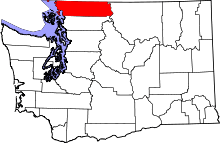 | |
| CDPs | ||
| Indian reservations | ||
| Unincorporated communities | ||
| Ghost towns | ||