Glacial Drumlin State Trail
| Glacial Drumlin State Trail | |
|---|---|
|
Trailhead Sign | |
| Location | Near Waukesha |
.png)
The Glacial Drumlin State Trail is a multipurpose rail trail in the Midwestern United States. It stretches 52 miles from Waukesha, Wisconsin (near Milwaukee) to Cottage Grove, Wisconsin (near Madison).[1] The trail travels through the Wisconsin cities of Cottage Grove, Deerfield, London, Lake Mills, Jefferson, Helenville, Sullivan, Dousman, Wales, and Waukesha.[2] In Lake Mills, Wisconsin it crosses the Rock Lake on one of its many old railroad bridges. The trail was opened in 1986 and follows the old Chicago and North Western Railway track.[3]
The name refers to a drumlin, a glacial landform very common in the area.[4]
About the trail
Traveling west from Waukesha, Wisconsin the trail runs continually for about 22 miles until you reach Jefferson, Wisconsin. In Jefferson the trail takes a 1.5-mile detour where bikers travel along various roads until reconnection with the trail. Road signs guide travelers through this part of the trail.[5]
The surface of the trail is paved in Asphalt for the first 13 miles when traveling from Waukesha Westward. Then the trail switches to crushed limestone for the remaining 39 miles.[6]
There are multiple rest stations at various locations along the trail. Most have running water and shade provided by an awning. Trail maps are also on display at these locations. There are also several parks along the trail that provide bathrooms and water.[7]
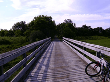
A total of 16 wooden bridges are situated along the trail. Of these, two are more than 300 feet long and one (the Big Muck Farm Bridge) is more than 880 feet long; however, the Big Muck Farm Bridge, located several miles west of Lake Mills, is currently closed due to flood damage suffered in 2008. A 0.7-mile detour is routed through Zeloski Marsh State Wildlife Area on the south side of the bridge. The decks of these bridges are constructed with 2x8 or 2x10 inch treated lumber that has been attached over the existing railroad ties.[8]
Passes and Fees
Trail passes are required for any person age 16 or older for biking and in-line skating. A state trail pass is not required for walking, hiking, or skiing. Every trail pass is issued to the person, not the bike, horse, motorcycle, etc. A pass may not be transferred between persons and must be filled out to be valid. Passes can be purchased online or on location at the trail itself. Self-pay boxes are located in Cottage Grove, Deerfield, Lake Mills, Jefferson, Wales, and at County Highway TT.
Trail passes are issued on an Annual or Daily Basis. The 2016 price for an annual trail pass is $25 and for a daily pass is $5 per person. These prices are the same for residents and non-residents of Wisconsin. The annual state trail pass is good for the entire calendar year (January 1 to December 31) and the daily pass is good for the day of purchase.
A trail pass must be purchased before using the trail. A $5 surcharge will be added to the cost of a trail pass to anyone who fails to purchase a trail pass before using the trail. A citation can be issued for anyone who refuses to buy a pass or self-register.[9][10]
Camp Grounds Around the area
Camping opportunities near the Glacial Drumlin State Trail are available throughout the year at campgrounds in the Southern Unit of the Kettle Moraine State Forest, Lake Kegonsa State Park, Capital Springs State Recreation Area and at the Sandhill Station State Campground[11][12]
Winter activities
Snowmobiling, cross-country skiing, and snowshoe hiking are permitted on the trail during the winter months. Snowmobiles are only permitted on the 39-mile limestone section of the trail but not on the paved asphalt section between Waukesha and Dousman. Snowmobiles must follow all Wisconsin snowmobile laws on this trail.
Skiers and snowshoe hikers must share the trail with snowmobilers. Skiers and snowshoe hikers do not need a trail pass to use the trail.[13]
Notes
The 5.1-mile section of the trail between Lake Mills and London is occasionally closed to accommodate aerial field spraying for farms in the area.[14]
External links
References
- ↑ http://www.midwestroads.com/craigholl/bike/glacialdrumlin.html
- ↑ http://dnr.wi.gov/org/land/parks/specific/glacialdrumlin/
- ↑ http://www.midwestroads.com/craigholl/bike/glacialdrumlin.html
- ↑ Drumlins in Wisconsin
- ↑ http://www.traillink.com/trail/glacial-drumlin-state-trail.aspx
- ↑ http://dnr.wi.gov/org/land/parks/specific/glacialdrumlin/
- ↑ http://www.midwestroads.com/craigholl/bike/glacialdrumlin.html
- ↑ http://dnr.wi.gov/news/BreakingNews_Lookup.asp?id=1070
- ↑ http://dnr.wi.gov/org/land/parks/specific/glacialdrumlin/
- ↑ http://dnr.wi.gov/topic/parks/trailpass.html
- ↑ . Camping Glacial Drumlin Trail
- ↑ http://www.gonomad.com/bicycle-tours/1007/wisconsin-drumlin-trail.html
- ↑ http://dnr.wi.gov/org/land/parks/specific/glacialdrumlin/
- ↑ http://www.wisconline.com/attractions/biketrails.html#glacialdrumlin
Coordinates: 43°03′51″N 88°54′48″W / 43.06417°N 88.91333°W