Gerrards Cross railway station
| Gerrards Cross | |
|---|---|
|
Gerrards Cross | |
| Location | |
| Place | Gerrards Cross |
| Local authority | District of South Bucks |
| Grid reference | TQ001887 |
| Operations | |
| Station code | GER |
| Managed by | Chiltern Railways |
| Number of platforms | 2 |
| DfT category | D |
|
Live arrivals/departures, station information and onward connections from National Rail Enquiries | |
| Annual rail passenger usage* | |
| 2002/03 |
|
| 2004/05 |
|
| 2005/06 |
|
| 2006/07 |
|
| 2007/08 |
|
| 2008/09 |
|
| 2009/10 |
|
| 2010/11 |
|
| 2011/12 |
|
| 2012/13 |
|
| 2013/14 |
|
| 2014/15 |
|
| History | |
| Key dates | Opened 1906 |
| National Rail – UK railway stations | |
| * Annual estimated passenger usage based on sales of tickets in stated financial year(s) which end or originate at Gerrards Cross from Office of Rail and Road statistics. Methodology may vary year on year. | |
|
| |
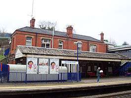
Gerrards Cross railway station is a railway station in the village of Gerrards Cross in Buckinghamshire, England. It is on the Chiltern Main Line between Denham Golf Club and Seer Green and Jordans.
Service
The station consists of two platforms, with a turn back siding just west of the station to allow trains to terminate/start at Gerrards Cross.The typical off-peak service pattern (as of the summer 2014 timetable) sees four trains per hour to London Marylebone. One of these is a stopping service which calls at most intermediate stations, and originates at Gerrards Cross. One train, that starts from High Wycombe, calls only at South Ruislip and Wembley Stadium. The other two are non-stop to Marylebone. These services originate at Bicester North and Princes Risborough. At peak times and weekends some trains operate through to Aylesbury via Monks Risborough.[1]
As recently as 2011 a single weekday service to London Paddington started from Gerrards Cross,[2] running non-stop from West Ruislip. An equivalent service departed from Paddington, and ran non-stop to Gerrards Cross. These trains traversed the now-rarely used former main line between Northolt Junction and Old Oak Common Junction, in many places reduced to a single track. This section is used more frequently by freight and waste trains, and also diversions during engineering works. These services now operate only between either South Ruislip or West Ruislip and Paddington.
History
The station was built as part of the Great Western and Great Central Joint Railway and was opened in April 1906 as Gerrards Cross for the Chalfonts. It is in a deep cutting that was dug for the line to maintain a very shallow maximum gradient, to allow for fast running with steam-hauled trains. The original station layout was four-track, with two through roads and two platform roads. There was a small goods yard north of the line. This has now been removed, but services from Marylebone that terminate at Gerrards Cross use the siding there.
The new line and station virtually created the present Gerrards Cross; the original settlement lay for the most part along the Oxford Road.
The station was transferred from the Western Region of British Railways to the London Midland Region on 24 March 1974.[3]
The bronze 'railway navvy' sculpture behind the up platform was created by Anthony Stones who was commissioned in 1992 by the Colne Valley Park Groundwork Trust. The band Genesis contributed £3,000 towards the cost of the sculpture in appreciation of their song 'Driving the Last Spike' on their album We Can't Dance.
In October 2007 work began on installing ticket barriers; these became operational on Monday 10 March 2008.
Tunnel works
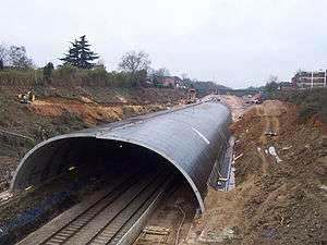
A development by the Tesco supermarket chain turned the cutting on the London side of the station into a tunnel by the use of large concrete ring segments to form the tunnel profile. The space on top of these segments was filled in to form a ground surface on which the new supermarket was built.
Service interruption
At 19:35 on 30 June 2005, 20 metres (66 ft) of tunnel roof near its eastern end collapsed, depositing broken tunnel segment fragments and many tonnes of infill material on the track. News pictures showed that the concrete segments adjoining the hole, which were still in place, appeared to have bowed downwards where two segments met.
A Marylebone-bound train was standing at the "up" platform when the tunnel collapsed. Its driver saw the collapse and raised the alarm, so all rail traffic was stopped. No one was injured. A "down" train that had left Denham had to make an emergency stop between stations and go back to Denham Golf Club to allow its passengers to alight. Again, no one was injured.
Service restoration and line centenary
Following work on removing infill material and various concrete segments, both those that actually failed and those that were judged unsafe but had not actually collapsed, the trackwork and signalling system were restored. Train services resumed from start of the normal timetable on Saturday 20 August 2005.
Gerrards Cross railway station had its centenary in 2006. This was celebrated with two London, Midland and Scottish Railway steam locomotives, Class 8F 48151 and Jubilee Class 5690 Leander, hauling trains between Marylebone and High Wycombe.
| Preceding station | |
Following station | ||
|---|---|---|---|---|
| Seer Green and Jordans | Chiltern Railways London-Birmingham |
Denham Golf Club | ||
| Beaconsfield | Chiltern Railways Chiltern Main Line fast services |
London Marylebone | ||
| Seer Green and Jordans | Chiltern Railways London Paddington - High Wycombe Monday-Friday Only |
London Paddington | ||
References
- ↑ http://www.chilternrailways.co.uk/sites/default/files/Timetable_19th_May_2014.pdf
- ↑ "Timetable 11" (PDF). Chiltern Railways. December 2011 to 13 May 2012. Retrieved 7 February 2012. Check date values in:
|date=(help) - ↑ Slater, J.N., ed. (May 1974). "Notes and News: Transfer of Marylebone-Banbury services". Railway Magazine. London: IPC Transport Press Ltd. 120 (877): 248. ISSN 0033-8923.
External links
- Train times and station information for Gerrards Cross railway station from National Rail
- BBC News Online - Tunnel collapses onto rail line
- Information and news on the Gerrards Cross Tunnel
Coordinates: 51°35′20″N 0°33′18″W / 51.589°N 0.555°W