Georgia State Route 189
| ||||
|---|---|---|---|---|
| Lookout Mountain Scenic Highway | ||||
 | ||||
| Route information | ||||
| Maintained by GDOT | ||||
| Length: | 15.7 mi[1] (25.3 km) | |||
| Major junctions | ||||
| South end: |
| |||
| South end: |
| |||
| Location | ||||
| Counties: | Dade, Walker | |||
| Highway system | ||||
| ||||

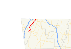
State Route 189 (SR 189) is a 15.7-mile-long (25.3 km) state highway that runs south-to-north through portions of Dade and Walker counties in the northwestern part of the U.S. state of Georgia.
Route description
SR 189 begins at an intersection with SR 136 southeast of Trenton, in Dade County. It heads northeast through part of Cloudland Canyon State Park and has a small wobble into Walker County before going back into Dade County. It heads northwest and curves to the northeast until it meets SR 157 (Hinkle Road). The two routes run concurrent to the northeast. On the southwestern edge of Lookout Mountain, they cut across the eastern edge of Covenant College. They briefly run along the Dade–Walker county line, with SR 157 splitting off onto McFarland Road, before SR 189 crosses back into Dade County. The road enters Walker County for the last time until it meets its northern terminus, a connection with Tennessee State Route 148 at the Tennessee state line on the Lookout Mountain, Georgia–Lookout Mountain, Tennessee city line.[1]
SR 189 is not part of the National Highway System, a system of roadways important to the nation's economy, defense, and mobility.[2]
Major intersections
| County | Location | mi[1] | km | Destinations | Notes | |||
|---|---|---|---|---|---|---|---|---|
| Dade | | 0.0 | 0.0 | Southern terminus | ||||
| Walker |
No major junctions | |||||||
| Dade | | 11.1 | 17.9 | Southern end of SR 157 concurrency | ||||
| Dade–Walker county line | Lookout Mountain | 14.9 | 24.0 | Northern end of SR 157 concurrency | ||||
| Walker |
No major junctions | |||||||
| Tennessee state line | 15.7 | 25.3 | Northern terminus; roadway continues as | |||||
1.000 mi = 1.609 km; 1.000 km = 0.621 mi
| ||||||||
See also
-
.svg.png) Georgia (U.S. state) portal
Georgia (U.S. state) portal -
 U.S. Roads portal
References
- 1 2 3 Google (December 15, 2013). "Route of SR 189" (Map). Google Maps. Google. Retrieved December 15, 2013.
- ↑ "National Highway System: Georgia" (PDF). United States Department of Transportation. May 8, 2009. Retrieved June 21, 2013.