Dade County, Georgia
| Dade County, Georgia | |
|---|---|
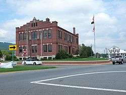 Dade County Courthouse in Trenton | |
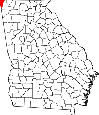 Location in the U.S. state of Georgia | |
 Georgia's location in the U.S. | |
| Founded | 1837 |
| Named for | Francis L. Dade |
| Seat | Trenton |
| Largest city | Trenton |
| Area | |
| • Total | 174 sq mi (451 km2) |
| • Land | 174 sq mi (451 km2) |
| • Water | 0.2 sq mi (1 km2), 0.1% |
| Population | |
| • (2010) | 16,633 |
| • Density | 96/sq mi (37/km²) |
| Congressional district | 14th |
| Time zone | Eastern: UTC-5/-4 |
| Website |
www |
Dade County is a county in the U.S. state of Georgia. It occupies the northwest corner of Georgia, and the county's own northwest corner is the westernmost point in the state. As of the 2010 census, the population is 16,633.[1] The county seat and only incorporated municipality is Trenton.[2]
Dade County is part of the Chattanooga, TN–GA Metropolitan Statistical Area.
In 1860, residents of Dade County voted to secede from the state of Georgia and from the United States, but no government outside the county ever recognized this gesture as legal. In 1945, the county symbolically "rejoined" Georgia and the United States.[3] However, in 1999, it was left off of the Georgia State Quarter.
History
Dade County was established in 1837 and was named for Major Francis Langhorne Dade, who was killed in the Dade Massacre by Seminole Indians in December 1835.[4] The first settlers of Dade County won the land in the Georgia Land Lotteries, held to encourage settlement after the Cherokee people were forced off the land. Many settlers worked in regional coke and coal mines that contributed to development of the Chattanooga, Tennessee area.
The area was long isolated from the rest of Georgia by its geography of mountains and rivers, which some historians say contributed to early residents' separatist attitudes. Georgia did not have a road connecting Dade County to the rest of the state until the establishment of Cloudland Canyon State Park in 1939. That year Georgia began work on Highway 136 to connect U.S. 41 to the recently created park.[5] The Civilian Conservation Corps built many of the facilities and access roads to the park. Up until then, travelers from elsewhere in Georgia could drive to the county only by way of Alabama or Tennessee.
Dade County had a short-lived state secessionist movement before the American Civil War. In 1860, county residents wanted to secede from the Union, but lawmakers for the state of Georgia were cautious. Legend has it that in 1860, the people of Dade County were so impatient that they announced their own secession from both Georgia and the United States.[6] On July 4, 1945, a telegram from President Harry S. Truman was read at a celebration marking the county's "rejoining" the Union. Historians say Dade's individual secession and readmission were symbolic and had no legal effect. They say that officially, Dade County seceded along with the state of Georgia in 1861 and re-entered the Union with the state in 1870.[7][8]
The noted Southern humorist, author and seminal writer of Southern humor George Washington Harris (1814-1869) is buried in the Brock Cemetery in Trenton. Although he greatly influenced the literary works of Mark Twain, William Faulkner,[9] and Flannery O'Connor,[10] his grave was not verified and given a marker until 2008.
In 1964 Covenant College established a campus at Lookout Mountain. Founded in 1955 in California, it was ready to expand after a year. Several professors led Covenant to move to St. Louis, Missouri, where it developed for eight years. After outgrowing its facilities there, the college decided to move to Dade County.
Quarter controversy
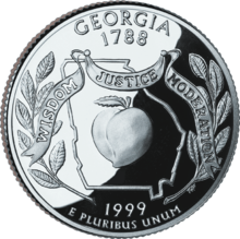
Shortly after the Georgia State Quarter was released by the US Mint, Dade County gained attention because of an apparent mistake in the design. As shown on the quarter, the state appears to lack Dade County, in the extreme northwestern part of the state. Some accounts in 2012 suggest the exclusion was intended to refer to the local legend of Dade County's secession from Georgia.[11]
Geography
According to the U.S. Census Bureau, the county has a total area of 174 square miles (450 km2), of which 174 square miles (450 km2) is land and 0.2 square miles (0.52 km2) (0.1%) is water.[12]
The vast majority of Dade County is located in the Middle Tennessee-Chickamauga sub-basin of the Middle Tennessee-Hiwassee basin. A very small part of the southernmost tip of the county is located in the Upper Coosa River sub-basin in the ACT River Basin (Coosa-Tallapoosa River Basin), while a small part of the westernmost portion of Dade County is located in the Guntersville Lake sub-basin in the Middle Tennessee-Elk basin.[13]
Major highways

-
.svg.png)
 Interstate 24 / State Route 409
 -
.svg.png)
 Interstate 59 / State Route 406
 -

 U.S. Route 11 / State Route 58
 -
 State Route 136
 -
 State Route 157
 -
 State Route 189
 -
 State Route 299
 -
 State Route 301
Adjacent counties
- Marion County, Tennessee (north)
- Hamilton County, Tennessee (northeast)
- Walker County (southeast)
- DeKalb County, Alabama (southwest)
- Jackson County, Alabama (west)
Protected areas
Demographics
| Historical population | |||
|---|---|---|---|
| Census | Pop. | %± | |
| 1840 | 1,364 | — | |
| 1850 | 2,680 | 96.5% | |
| 1860 | 3,069 | 14.5% | |
| 1870 | 3,033 | −1.2% | |
| 1880 | 4,702 | 55.0% | |
| 1890 | 5,707 | 21.4% | |
| 1900 | 4,578 | −19.8% | |
| 1910 | 4,139 | −9.6% | |
| 1920 | 3,918 | −5.3% | |
| 1930 | 4,146 | 5.8% | |
| 1940 | 5,894 | 42.2% | |
| 1950 | 7,364 | 24.9% | |
| 1960 | 8,666 | 17.7% | |
| 1970 | 9,910 | 14.4% | |
| 1980 | 12,318 | 24.3% | |
| 1990 | 13,147 | 6.7% | |
| 2000 | 15,154 | 15.3% | |
| 2010 | 16,633 | 9.8% | |
| Est. 2015 | 16,264 | [14] | −2.2% |
| U.S. Decennial Census[15] 1790-1960[16] 1900-1990[17] 1990-2000[18] 2010-2013[1] | |||
2000 census
As of the census[19] of 2000, there were 15,154 people, 5,633 households, and 4,264 families residing in the county. The population density was 87 people per square mile (34/km²). There were 6,224 housing units at an average density of 36 per square mile (14/km²). The racial makeup of the county was 97.51% White, 0.63% Black or African American, 0.49% Native American, 0.38% Asian, 0.03% Pacific Islander, 0.20% from other races, and 0.76% from two or more races. 0.90% of the population were Hispanic or Latino of any race.
There were 5,633 households out of which 33.30% had children under the age of 18 living with them, 62.70% were married couples living together, 9.50% had a female householder with no husband present, and 24.30% were non-families. 21.70% of all households were made up of individuals and 8.20% had someone living alone who was 65 years of age or older. The average household size was 2.55 and the average family size was 2.97.
In the county the population was spread out with 23.80% under the age of 18, 11.80% from 18 to 24, 27.80% from 25 to 44, 24.50% from 45 to 64, and 12.00% who were 65 years of age or older. The median age was 36 years. For every 100 females there were 96.00 males. For every 100 females age 18 and over, there were 91.80 males.
The median income for a household in the county was $35,259, and the median income for a family was $39,481. Males had a median income of $31,534 versus $21,753 for females. The per capita income for the county was $16,127. About 7.50% of families and 9.70% of the population were below the poverty line, including 7.40% of those under age 18 and 12.50% of those age 65 or over.
2010 census
As of the 2010 United States Census, there were 16,633 people, 6,291 households, and 4,462 families residing in the county.[20] The population density was 95.6 inhabitants per square mile (36.9/km2). There were 7,305 housing units at an average density of 42.0 per square mile (16.2/km2).[21] The racial makeup of the county was 96.0% white, 0.9% black or African American, 0.7% Asian, 0.4% American Indian, 0.1% Pacific islander, 0.6% from other races, and 1.3% from two or more races. Those of Hispanic or Latino origin made up 1.8% of the population.[20] In terms of ancestry, 21.2% were American, 18.1% were Irish, 11.4% were German, and 9.4% were English.[22]
Of the 6,291 households, 31.6% had children under the age of 18 living with them, 56.2% were married couples living together, 10.4% had a female householder with no husband present, 29.1% were non-families, and 25.1% of all households were made up of individuals. The average household size was 2.49 and the average family size was 2.96. The median age was 39.0 years.[20]
The median income for a household in the county was $39,760 and the median income for a family was $48,881. Males had a median income of $41,618 versus $26,521 for females. The per capita income for the county was $20,168. About 10.7% of families and 15.5% of the population were below the poverty line, including 25.8% of those under age 18 and 10.8% of those age 65 or over.[23]
Education
Georgia water supply
Dade County lies just south of Nickajack Lake on the Tennessee River, which was created by the Nickajack Dam, constructed by the Tennessee Valley Authority. The city of Atlanta, Georgia wanted to gain rights to the water in Nickajack Lake to supplement their sources from Lake Lanier and Lake Allatoona. In addition, in 2008 Georgia lawmakers wanted to change the Tennessee-Georgia state line, as they say it is based on a flawed 1818 survey, which mistakenly placed Georgia's northern line just short of the Tennessee River.[24][25] Changing the boundary would give Georgia rights to the water, but they were unsuccessful.
Communities
- Rising Fawn
- Trenton
- Wildwood
- Davis
- West Brow
- New Salem
- New Home
See also
- National Register of Historic Places listings in Dade County, Georgia
- Northwest Georgia Joint Development Authority
- Town Line, New York, seceded from the United States (unrecognized) and rejoined in 1946.
References
- 1 2 "State & County QuickFacts". United States Census Bureau. Retrieved June 21, 2014.
- ↑ "Find a County". National Association of Counties. Retrieved 2011-06-07.
- ↑ Dade County, Georgia. "The State Of Dade". Dade County, Georgia. Retrieved 4 April 2012.
- ↑ Gannett, Henry (1905). The Origin of Certain Place Names in the United States. Govt. Print. Off. p. 98.
- ↑ Cooksey, Elizabeth (2009). "Dade County". The New Georgia Encyclopedia. Georgia Humanities Council/University of Georgia Press. Retrieved 2009-07-15.
- ↑ Bluestein, Greg (28 April 2008). "Forgotten Ga. county now in spotlight over water rights". Fox News. Fox Entertainment Group. Retrieved 29 October 2014.
- ↑ "The Independent State Of Dade Is Fixin' To Rise Again". Dade County Sentinel. Retrieved 2012-12-22.
- ↑ Coulter, E. Merton. "The Myth of Dade County's Seceding from Georgia in 1860", Resources at Rootsweb
- ↑ Faulkner, William. "The Art of Fiction no. 12: William Faulkner". The Paris Review. Retrieved 9 December 2012.
- ↑ Donald Day, "The Life of George Washington Harris," Tennessee Historical Quarterly, Vol. 6, No. 1 (March 1947), pp. 3-38.
- ↑ "Georgia quarters are really quite peachy, but not in Dade County". Valuable-coin-stories.com. Archived from the original on 22 Nov 2012. Retrieved 2014-04-07.
- ↑ "US Gazetteer files: 2010, 2000, and 1990". United States Census Bureau. 2011-02-12. Retrieved 2011-04-23.
- ↑ "Georgia Soil and Water Conservation Commission Interactive Mapping Experience". Georgia Soil and Water Conservation Commission. Retrieved 2015-11-19.
- ↑ "County Totals Dataset: Population, Population Change and Estimated Components of Population Change: April 1, 2010 to July 1, 2015". Retrieved July 2, 2016.
- ↑ "U.S. Decennial Census". United States Census Bureau. Retrieved June 21, 2014.
- ↑ "Historical Census Browser". University of Virginia Library. Retrieved June 21, 2014.
- ↑ "Population of Counties by Decennial Census: 1900 to 1990". United States Census Bureau. Retrieved June 21, 2014.
- ↑ "Census 2000 PHC-T-4. Ranking Tables for Counties: 1990 and 2000" (PDF). United States Census Bureau. Retrieved June 21, 2014.
- ↑ "American FactFinder". United States Census Bureau. Retrieved 2011-05-14.
- 1 2 3 "DP-1 Profile of General Population and Housing Characteristics: 2010 Demographic Profile Data". United States Census Bureau. Retrieved 2015-12-29.
- ↑ "Population, Housing Units, Area, and Density: 2010 - County". United States Census Bureau. Retrieved 2015-12-29.
- ↑ "DP02 SELECTED SOCIAL CHARACTERISTICS IN THE UNITED STATES – 2006-2010 American Community Survey 5-Year Estimates". United States Census Bureau. Retrieved 2015-12-29.
- ↑ "DP03 SELECTED ECONOMIC CHARACTERISTICS – 2006-2010 American Community Survey 5-Year Estimates". United States Census Bureau. Retrieved 2015-12-29.
- ↑ Bluestein, Greg - Forgotten Ga. county now in spotlight over water rights, Associated Press, April 28, 2008
- ↑ Shearer, Lee - "Tennessee-Georgia border dispute derided", The Athens Banner-Herald, 3 March 2008
External links
- Dade County historical marker
 |
Marion County, Tennessee | Hamilton County, Tennessee | | |
| Jackson County, Alabama | |
|||
| ||||
| | ||||
| DeKalb County, Alabama | Walker County |
Municipalities and communities of Dade County, Georgia, United States | ||
|---|---|---|
| City | | |
| Unincorporated communities | ||
Coordinates: 34°51′N 85°30′W / 34.85°N 85.50°W