Geographic center of the contiguous United States

The geographic center of the contiguous United States is the center of 48 U.S. states. It has been regarded as such by the U.S. National Geodetic Survey (NGS) since the 1912 additions of New Mexico and Arizona to the United States.
Overview
Its position as located in a 1918 survey is located at 39°50′N 98°35′W / 39.833°N 98.583°W, in Kansas about 2.6 miles (4.2 km) northwest of the center of Lebanon, approximately 12 miles (19 km) south of the Kansas-Nebraska border.[1]
While any measurement of the exact center of a land mass will always be imprecise due to changing shorelines and other factors, the NGS coordinates are recognized in a historical marker in a small park at the intersection of AA Road and K-191. It is accessible by a turn-off from U.S. Route 281.
It is distinct from the geographic center of the United States, which reflects the 1959 additions of the states of Alaska and Hawaii, which is located at a point northeast of Belle Fourche, South Dakota.
In an unusual technical glitch, a farmstead northeast of Potwin, Kansas became the default site of 600 million IP addresses (due to their lack of fine granularity) when the Massachusetts-based digital mapping company MaxMind changed the putative geographic center of the contiguous United States from 39.8333333,-98.585522 to 38.0000,-97.0000.[2]
Marker

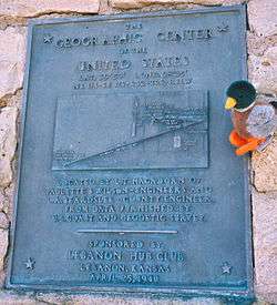

In order to protect the privacy of the private land owner where the point identified by the 1918 survey falls,[3] a proxy marker was erected in 1940 some half a mile away.[4]
Its inscription reads:
The GEOGRAPHIC CENTER of the UNITED STATES
LAT. 39°50' LONG. -98°35'
NE 1/4 - SE 1/4 - S32 - T2S - R11W
Located by L.T. Hagadorn of Paulette & Wilson - Engineers and L.A. Beardslee - County Engineer. From data furnished by U.S. Coast and Geodetic Survey.
Sponsored by Lebanon Hub Club. Lebanon, Kansas. April 25, 1940
An American flag usually flies atop a pole placed on the monument. A covered picnic area and small four-pew chapel are nearby.
Method of measurement
In 1918, the Coast and Geodetic Survey found this location by balancing on a point a cardboard cutout shaped like the U.S.[5] Incredibly, this method was accurate to within 20 miles, but while the Geodetic Survey no longer endorses any location as the center of the U.S., the identification of Lebanon, Kansas has remained.[6][7]
See also
- Geographic center
- Geographic center of the United States
- Geographic centers of the United States
- Mean center of U.S. population
- Extreme points of the United States
- Centroid
References
- ↑ "Geographical Centers of the United States" (PDF). USGS Publications Warehouse. U.S. Department of the Interior Geological Survey. 1964. Retrieved 13 May 2015.
- ↑ Hill, Kashmir (2016-04-10). "How an internet mapping glitch turned a random Kansas farm into a digital hell". Fusion. Retrieved 2016-04-10.
- ↑ "The actual center is about a half mile away in the center of a former hog farm." (kansastravel.org Archived August 25, 2006, at the Wayback Machine.)
- ↑ Walter H. Schoewe, "Kansas and the geodetic datum of North America", Transactions of the Kansas Academy of Science 51 (1948) 117–124, www.jstor.org
- ↑ "Geographic Center of the United States" (PDF). National Geodetic Survey Publications. National Geodetic Survey. Retrieved 13 May 2015. Includes a reprint of Adams, Oscar S. (1932). "Geographical Ceters". The Military Engineer. 24 (138): 586–587. Describes cardboard method used "a number of years ago".
- ↑ Keith Stokes (2008-06-01). "Geographic Center of the United States". Kansastravel.org. Retrieved 2016-03-07.
- ↑ "The Geographical Center of the Lower 48 United States, at Lebanon, Kansas". Archived from the original on August 25, 2006. Retrieved June 1, 2006.
External links
- Smith County Map, KDOT
- Kansas Travel article
- In the Middle of Nowhere, a Nation’s Center, New York Times
- Center for Land Use Interpretation article about the origins and accuracy of the marker
- Roadside America article
- USGS information
- The Center of the United States article about applying mathematical methods to geography
Coordinates: 39°49′41″N 98°34′46″W / 39.828175°N 98.579500°W