Gaua
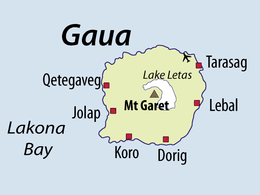 Map of Gaua | |
 | |
| Geography | |
|---|---|
| Location | Pacific Ocean |
| Coordinates | 14°15′54″S 167°31′12″E / 14.26500°S 167.52000°ECoordinates: 14°15′54″S 167°31′12″E / 14.26500°S 167.52000°E |
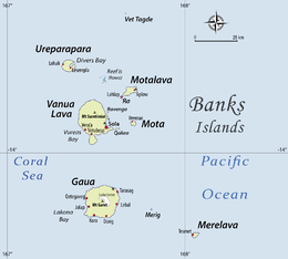
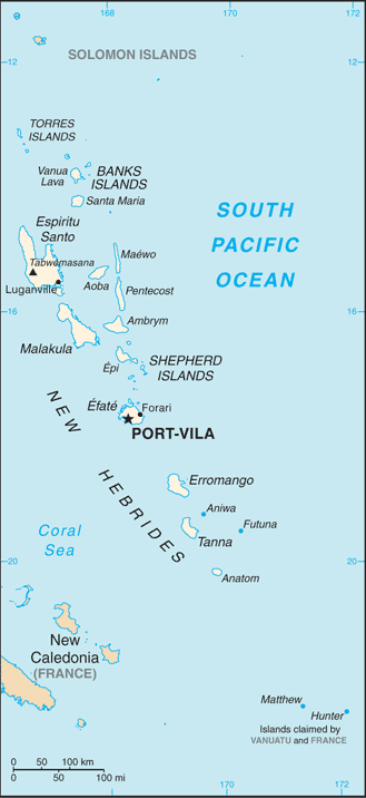
| Archipelago | Vanuatu, Banks Islands |
| Area | 342 km2 (132 sq mi) |
| Highest elevation | 767 m (2,516 ft) |
| Highest point | Mount Gharat |
| Administration | |
|
Vanuatu | |
| Province | Torba Province |
| Largest settlement | Jolap |
| Demographics | |
| Population | 2,491 (2009) |
| Pop. density | 2.2 /km2 (5.7 /sq mi) |
Gaua (formerly known as Santa Maria Island) is the largest and second most populous of the Banks Islands in Torba Province of northern Vanuatu. It covers 342 km².
History
Gaua was first sighted by Europeans during the Spanish expedition of Pedro Fernández de Quirós, from 25 to 29 April 1606. The island’s name was then charted as Santa María.[1]
Physical geography
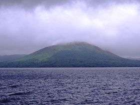
It has rugged terrain, reaching up to Mount Gharat (797 m), the peak of the active stratovolcano at the center of the island. The most recent eruption was in 2013. The volcano has a 6 x 9 km caldera, within which lies a crater lake known as Lake Letas, the largest lake in Vanuatu. To the east of the lake is Siri Waterfall (120 m drop).
Population and languages
The island has a population of 2491 (in 2009), with an annual growth rate of 2.0 percent.[2] This population is scattered in various coastal villages on the western, southern and northeastern sides of the island. The eastern side has a few hamlets with an immigrant population coming mainly from the two smaller islands Merig and Merelava, southeast of Gaua. The largest village is Jolap, on the west coast.[3]
Besides the language of this immigrant population (Mwerlap), there are five languages traditionally spoken on Gaua: Lakon or Vuré; Olrat; Koro; Dorig and Nume.
Economy
The population of Gaua lives of the traditional agricultural economy of Melanesia, combining fishing and horticulture. The principal exports are copra and cacao.
Transportation
The island is served by Gaua Airport at the northeast corner of the island.
Gallery
-
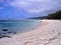
Baravit Beach (east coast)
-

Local people
-
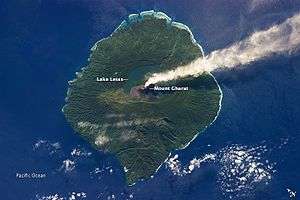
Gaua as seen from space

References
- ↑ Kelly, Celsus, O.F.M. La Austrialia del Espíritu Santo. The Journal of Fray Martín de Munilla O.F.M. and other documents relating to the Voyage of Pedro Fernández de Quirós to the South Sea (1605-1606) and the Franciscan Missionary Plan (1617-1627) Cambridge, 1966, p.39, 62.
- ↑ "2009 National Census of Population and Housing: Summary Release" (PDF). Vanuatu National Statistics Office. 2009. Retrieved November 21, 2010.
- ↑ Satellite photo of Jolap village.
External links
- "Gaua". Global Volcanism Program. Smithsonian Institution.
- Our Forest our Future; Managing Biodiversity in the South Pacific, Gaua Island, Vanuatu, Rudolf Hahn, CTA FAO 2013, youtube video
- Volcano World: Gaua
- Detailed list and map of the Banks and Torres languages, including those of Gaua
| Provinces of Vanuatu |  | ||||||||||||||||||||||
|---|---|---|---|---|---|---|---|---|---|---|---|---|---|---|---|---|---|---|---|---|---|---|---|
| Islands and islets | |||||||||||||||||||||||