Merelava
Coordinates: 14°27′S 168°03′E / 14.45°S 168.05°E
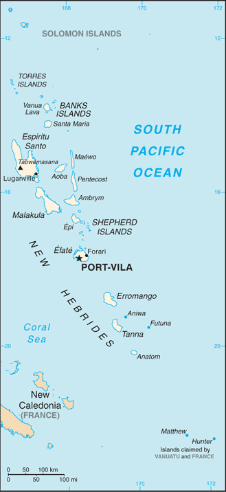
 Location of Merelava in the Banks Islands | |
 | |
| Geography | |
|---|---|
| Location | Pacific Ocean |
| Archipelago | Vanuatu, Banks Islands |
| Administration | |
|
Vanuatu | |
| Province | Torba Province |
| Demographics | |
| Population | 650 (2009) |
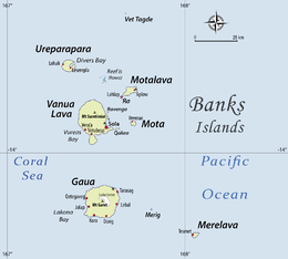
Merelava (or Mere Lava) is an island in the Banks Islands of northern Vanuatu.
It is situated in the southeastern part of the archipelago near Mota and Merig. The island is administratively part of Torba Province. Merelava has also been known as Star Island. It is located about 50 kilometres (31 miles) east of Gaua.
History
Merelava was first sighted by Europeans during the Spanish expedition of Pedro Fernández de Quirós, from 25 to 29 April 1606. The island’s name was then charted as San Marcos.[1]
Population and language
The island has about 650 inhabitants.[2] They all speak an Oceanic language known as Mwerlap or Merlav.[3]
Names
The inhabitants of Merelava call their own island Mwerlap, phonetically [ŋʷɞrlap], in the language of the same name.
The name Merelava (sometimes wrongly transcribed Mere Lava) reflects the way it is called in the neighbouring Mota language, phonetically [ŋ͡mʷereˈlaβa].
References
- ↑ Kelly, Celsus, O.F.M. La Austrialia del Espíritu Santo. The Journal of Fray Martín de Munilla O.F.M. and other documents relating to the Voyage of Pedro Fernández de Quirós to the South Sea (1605-1606) and the Franciscan Missionary Plan (1617-1627) Cambridge, 1966, p.39, 62.
- ↑ "2009 National Census of Population and Housing: Summary Release" (PDF). Vanuatu National Statistics Office. 2009. Retrieved October 11, 2010.
- ↑ François (2005:444)
Bibliography
- François, Alexandre (2005), "Unraveling the history of vowels in seventeen north Vanuatu languages" (PDF), Oceanic Linguistics, 44 (2): 443–504, doi:10.1353/ol.2005.0034
| Provinces of Vanuatu |  | ||||||||||||||||||||||
|---|---|---|---|---|---|---|---|---|---|---|---|---|---|---|---|---|---|---|---|---|---|---|---|
| Islands and islets | |||||||||||||||||||||||