Garrett, Wyoming
| Garrett, Wyoming | |
|---|---|
| Unincorporated community | |
 Garrett, Wyoming  Garrett, Wyoming Location within the state of Wyoming | |
| Coordinates: 42°6′48″N 105°36′36″W / 42.11333°N 105.61000°WCoordinates: 42°6′48″N 105°36′36″W / 42.11333°N 105.61000°W | |
| Country | United States |
| State | Wyoming |
| County | Albany |
| Time zone | Mountain (MST) (UTC-7) |
| • Summer (DST) | MDT (UTC-6) |
| ZIP codes | 82058 |
| GNIS feature ID | 1597328[1] |
Garrett is an unincorporated community in northern Albany County, Wyoming, United States, along the North Laramie River. It lies along local roads north of the city of Laramie, the county seat of Albany County.[2] Its elevation is 6,785 ft (2,068 m), and it is located at 42°6′48″N 105°36′36″W / 42.11333°N 105.61000°W.[1] Although Garrett is unincorporated, it once had a post office, with the ZIP code of 82058. The building remains, though is no longer in use.[3] Garrett is also home to River Bridge School, a one-room schoolhouse that is part of Albany County School District #1.[4] Aside from the schoolhouse, the land is privately owned.
References
- 1 2 "Garrett, Wyoming". Geographic Names Information System. United States Geological Survey.
- ↑ Rand McNally. The Road Atlas '08. Chicago: Rand McNally, 2008, p. 116.
- ↑ Zip Code Lookup
- ↑ "River Bridge School". ACSD #1.
Municipalities and communities of Albany County, Wyoming, United States | ||
|---|---|---|
| City | 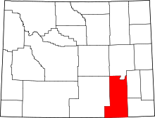 | |
| Town | ||
| CDPs | ||
| Unincorporated communities | ||
This article is issued from Wikipedia - version of the 9/7/2016. The text is available under the Creative Commons Attribution/Share Alike but additional terms may apply for the media files.