Garbh Eilean
| Gaelic name | Garbh Eilean |
|---|---|
| Meaning of name | Rough Isle |
| Location | |
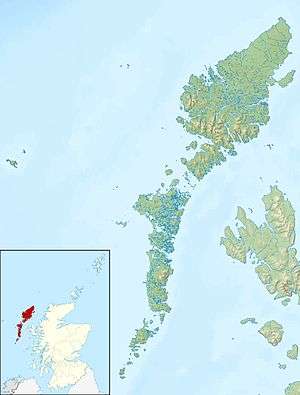 Garbh Eilean Garbh Eilean shown within the Outer Hebrides | |
| OS grid reference | NG414983 |
| Physical geography | |
| Island group | Shiant Isles |
| Area | 143 hectares (0.55 sq mi) |
| Area rank | 126 [1] |
| Highest elevation | Mullach Buidhe 160 m |
| Administration | |
| Sovereign state | United Kingdom |
| Country | Scotland |
| Council area | Comhairle nan Eilean Siar |
| Demographics | |
| Population | 0 |
| References | [2][3][4] |
Garbh Eilean (Scottish Gaelic Rough Isle) is one of the Shiant Isles at the south end of the Minch on the west coast of Scotland.

Geology
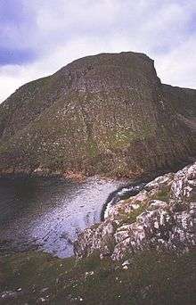
In geological terms, these islands essentially represent an extension of the Trotternish peninsula of Skye. The rocks are volcanic, and at 60Ma, very young by Hebridean standards. Dolerite columns on the north side of Garbh Eilean are over 100m tall and about 2m across. Similar to those at Staffa and the Giant's Causeway, they were formed by the slow cooling of volcanic rocks deep underground.[5] Intrusion sills show a progression in their chemical compositions, from olivine-rich rocks at the base to rocks with very little or no olivine at the top. The sills are thought to have formed by crystal settling. Recent study has suggested that at least one of the sills represents a multiple intrusion.[6] In some places the basalt is overlain by Jurassic mudstone, which weathers to form much more fertile soil than elsewhere in the Western Isles.
Economy
The islands were inhabited until the late 18th century, when changes in land ownership and society made the old way of life no longer viable. The previously inhabited and cultivated areas of Àirighean a’ Baigh and Àirighean na h-Annaid are unusually fertile land. Feannagan may still be made out in these areas.
Adam Nicolson, father of the present owner of the Shiants, published a book about them in 2001 under the title of Sea Room 'to tell the whole story'.[7]
Archaeology
There are several possible chapel sites. The first may have been dedicated to St Columba and have been on the west side of Garbh Eilean, perhaps at Àirighean na h-Annaid - the name Annaid means Old Church. There is also evidence of a more recent church, dedicated to the Virgin, near the present cottage on Eilean an Taighe.[7]
A gold torc was dredged up by some Scalpay scallop fishermen south-west of the islands. This beautiful object dates from perhaps 1200BC, and while similar such torcs have turned up elsewhere in UK, this is by far the furthest north.[7] It is possible to speculate endlessly about the provenance of such a find, and whether it got there by shipwreck, or as a votive offering.
Wildlife
The Shiants are a major seabird breeding ground due to their location next to good feeding grounds and lack of predators, except for black rats. Huge numbers of puffins breed in burrows on the slopes of Garbh Eilean, as well as significant numbers of guillemots, razorbills, fulmars, kittiwakes, shags, gulls and great skuas. Although St Kilda has more puffins, the sheer density on the Shiants is greater.[5][8] The island also has a population of black rats, which may originally have come ashore from a shipwreck. Analysis of their stomach contents has shown that the Shiant rats do eat seabirds, but it is impossible to tell if they prey on live birds or simply scavenge dead remains.[9] These rats are now rare in the UK but on the Shiants their numbers are still controlled in and around the house. Elsewhere on the islands they are unmolested.[3]
See also
Footnotes
- ↑ Area and population ranks: there are c. 300 islands over 20 ha in extent and 93 permanently inhabited islands were listed in the 2011 census.
- ↑ National Records of Scotland (15 August 2013) (pdf) Statistical Bulletin: 2011 Census: First Results on Population and Household Estimates for Scotland - Release 1C (Part Two). "Appendix 2: Population and households on Scotland’s inhabited islands". Retrieved 17 August 2013.
- 1 2 Haswell-Smith, Hamish. (2004) The Scottish Islands. Edinburgh. Canongate.
- ↑ Ordnance Survey. Get-a-map (Map). 1:25,000. Leisure. Ordinance Survey. Retrieved 21 August 2013.
- 1 2 "Western Isles Guide Book: Shiant Islands". Retrieved 2007-07-21.
- ↑ Kathryn Goodenough (September 1999). "Geological Conservation Review: Shiant Isles SSSI" (PDF). Scottish Natural Heritage. Retrieved 2007-07-21.
- 1 2 3 "Shiant Islands". Retrieved 2007-07-21.
- ↑ "Birds of the Shiant Islands: 1970 & 1971 census". Shiant Islands. Retrieved 2007-07-21.
- ↑ Paul Stapp (2002) Stable isotopes reveal evidence of predation by ship rats on seabirds on the Shiant Islands, Scotland Journal of Applied Ecology 39 (5), 831–840.
Coordinates: 57°54′N 6°22′W / 57.900°N 6.367°W