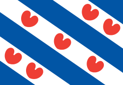
Friesland
| Friesland Fryslân | |||
|---|---|---|---|
| Province of the Netherlands | |||
| |||
|
Anthem: "De âlde Friezen" "The Old Frisians" | |||
 Location of Friesland in the Netherlands | |||
| Coordinates: 53°8′N 5°49′E / 53.133°N 5.817°ECoordinates: 53°8′N 5°49′E / 53.133°N 5.817°E | |||
| Country | Netherlands | ||
| Capital | Leeuwarden (Ljouwert) | ||
| Largest city | Leeuwarden (Ljouwert) | ||
| Government | |||
| • King's Commissioner | Joan Leemhuis-Stout (VVD) | ||
| Area | |||
| • Land | 3,349 km2 (1,293 sq mi) | ||
| • Water | 2,392 km2 (924 sq mi) | ||
| Area rank | 3rd nationally | ||
| Population (2010) | |||
| • Land | 646,305 | ||
| • Rank | 8th nationally | ||
| • Density | 190/km2 (500/sq mi) | ||
| • Density rank | 11th nationally | ||
| Time zone | CET (UTC+1) | ||
| • Summer (DST) | CEST (UTC+2) | ||
| ISO 3166 code | NL-FY | ||
| Religion (2005) |
Protestant 30% Roman Catholic 6% Muslim 2% | ||
| Website | www.fryslan.frl | ||
Friesland (Dutch pronunciation: [ˈfrislɑnt]; official, West Frisian: Fryslân [ˈfrislɔ̃ːn]) or Frisia is a province in the northwest of the Netherlands. It is situated west of Groningen, northwest of Drenthe and Overijssel, north of Flevoland, northeast of North Holland, and south of the North Sea. In 2010, the province had a population of 646,000 and a total area of 5,749 km2 (2,220 sq mi).
The capital and seat of the provincial government is the city of Leeuwarden (West Frisian: Ljouwert), a city with 91,817 inhabitants. Since 2016, Joan Leemhuis-Stout is the King's Commissioner in the province. A coalition of the Labour Party, the Christian Democratic Appeal, and the Frisian National Party forms the executive branch. The province is divided into 24 municipalities.
The area of the province was once part of the ancient, larger region of Frisia. The official languages of Friesland are West Lauwers Frisian and Dutch.
History
A proto-Frisian culture slowly began to emerge around 400–200 BC known for its artificial dwelling hills as a defence against the sea. The Roman claim on Frisia began in 12 BC with the campaign of Nero Claudius Drusus in Germania. After a series of costly battles against the Frisians, the Romans were suddenly sworn fealty. The de facto independence they later enjoyed as a Roman vassal shows that this might have been a mostly diplomatic decision based on the temporary favourable bargaining position. Together with other Germanic tribes such as the Salians (later Franks) and the Batavii they managed to keep the region north of the Lower Rhine mostly free from Roman influence.
The early eighth-century AD is known for the Frisian kingdom, king Redbad and the missionary Saint Boniface who was killed near Dokkum, Westlauwers Friesland.[1] At the start of the Middle Ages, the Frisian Kingdom reached its zenith, stretching from what is now the French/Belgian border to the River Weser in Germany, within its center the flourishing trading post Dorestad. After incorporation into the Frankish empire, Friesland was divided into three parts. The westernmost part developed at the start of the second millennium into the County of Holland, while the remainder of Frisia had no feudal overlord, a situation known as the Frisian freedom.
That ended when Charles V added Frisia to the Habsburg Netherlands as Lordship of Frisia. Under Napoleon, the department was named Frise. After Napoleon was defeated in 1813, the department became part of the United Kingdom of the Netherlands as the province of Friesland.
Cities
The ancient cities of Friesland are shown below:
| Dutch | West Frisian | Charter granted |
|---|---|---|
| Leeuwarden | Ljouwert | 1285 |
| Sneek | Snits | 1456 |
| IJlst | Drylts | 1268 |
| Sloten | Sleat | 1426 |
| Stavoren | Starum | 1118 |
| Hindeloopen | Hylpen | 1285 |
| Workum | Warkum | 1399 |
| Bolsward | Boalsert | 1455 |
| Harlingen | Harns | 1234 |
| Franeker | Frjentsjer | 1374 |
| Dokkum | Dokkum | 1298 |
Geography

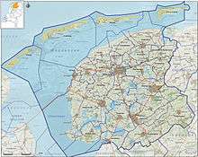

Friesland is situated at 53°8′N 5°49′E / 53.133°N 5.817°E in the northwest of the Netherlands, west of the province of Groningen, northwest of Drenthe and Overijssel, north of Flevoland, northeast of the IJsselmeer and North Holland, and south of the North Sea.
Friesland is the largest province of the Netherlands if one includes areas of water; in terms of land area only, it is the third largest province.
Most of Friesland is on the mainland, but it also includes a number of West Frisian Islands, including Vlieland, Terschelling, Ameland and Schiermonnikoog, which are connected to the mainland by ferry. The province's highest point is at 45 metres (148 ft) above sea level, on the island of Vlieland.
There are four national parks: Schiermonnikoog, De Alde Feanen, Lauwersmeer (in Groningen and Friesland), and Drents-Friese Wold (in Drenthe and Friesland).
Urban areas
The ten urban areas in Friesland with the largest population are:[2]
| Dutch name | Frisian name | Population |
|---|---|---|
| Leeuwarden | Ljouwert | 96,578 |
| Drachten | Drachten | 44,598 |
| Sneek | Snits | 33,401 |
| Heerenveen | Hearrenfean, ItIt Hearrenfean | 28,497 |
| Harlingen | Harns | 15,729 |
| Dokkum | Dokkum | 13,145 |
| Franeker | Frjentsjer | 12,995 |
| Joure | Jouwer, DeDe Jouwer | 12,902 |
| Wolvega | Wolvegea | 12,738 |
| Lemmer | Lemmer, DeDe Lemmer | 10,220 |
Municipalities
The province is divided into 24 municipalities, each with local government.
| Municipality | Population[3] | Total Area[4] | Population density[3][4] | COROP group | ||
|---|---|---|---|---|---|---|
| km2 | sq mi | /km2 | /sq mi | |||
| Achtkarspelen | 27,938 | 103.98 | 40.15 | 273 | 710 | North Friesland |
| Ameland | 3,591 | 268.50 | 103.67 | 61 | 160 | North Friesland |
| Dantumadiel | 19,017 | 87.53 | 33.80 | 223 | 580 | North Friesland |
| De Fryske Marren | 51,229 | 559.93 | 216.19 | 142 | 370 | South West Friesland |
| Dongeradeel | 24,097 | 266.92 | 103.06 | 144 | 370 | North Friesland |
| Ferwerderadiel | 8,755 | 133.18 | 51.42 | 90 | 230 | North Friesland |
| Franekeradeel | 20,445 | 109.17 | 42.15 | 199 | 520 | North Friesland |
| Harlingen | 15,769 | 387.67 | 149.68 | 630 | 1,600 | North Friesland |
| Heerenveen | 49,528 | 187.76 | 72.49 | 274 | 710 | South East Friesland |
| Het Bildt | 10,657 | 116.48 | 44.97 | 115 | 300 | North Friesland |
| Kollumerland c.a. | 12,905 | 116.35 | 44.92 | 118 | 310 | North Friesland |
| Leeuwarden | 108,249 | 166.99 | 64.48 | 714 | 1,850 | North Friesland |
| Leeuwarderadeel | 10,264 | 41.46 | 16.01 | 251 | 650 | North Friesland |
| Littenseradiel | 10,900 | 132.64 | 51.21 | 83 | 210 | North Friesland |
| Menaldumadeel | 13,614 | 70.03 | 27.04 | 198 | 510 | North Friesland |
| Ooststellingwerf | 25,696 | 226.11 | 87.30 | 115 | 300 | South East Friesland |
| Opsterland | 29,883 | 227.64 | 87.89 | 133 | 340 | South East Friesland |
| Schiermonnikoog | 942 | 199.07 | 76.86 | 21 | 54 | North Friesland |
| Smallingerland | 55,505 | 126.17 | 48.71 | 469 | 1,210 | South East Friesland |
| Súdwest-Fryslân | 84,356 | 841.56 | 324.93 | 184 | 480 | South West Friesland |
| Terschelling | 4,721 | 673.99 | 260.23 | 55 | 140 | North Friesland |
| Tytsjerksteradiel | 31,940 | 161.41 | 62.32 | 214 | 550 | North Friesland |
| Vlieland | 1,113 | 315.80 | 121.93 | 31 | 80 | North Friesland |
| Weststellingwerf | 25,486 | 228.45 | 88.21 | 115 | 300 | South East Friesland |
Climate
The province of Friesland has an oceanic climate (Köppen climate classification: Cfb).
| Climate data for Leeuwarden | |||||||||||||
|---|---|---|---|---|---|---|---|---|---|---|---|---|---|
| Month | Jan | Feb | Mar | Apr | May | Jun | Jul | Aug | Sep | Oct | Nov | Dec | Year |
| Record high °C (°F) | 12.6 (54.7) |
14.4 (57.9) |
20.4 (68.7) |
26.0 (78.8) |
28.7 (83.7) |
32.5 (90.5) |
31.4 (88.5) |
32.8 (91) |
29.1 (84.4) |
23.8 (74.8) |
16.4 (61.5) |
14.2 (57.6) |
32.8 (91) |
| Average high °C (°F) | 4.9 (40.8) |
5.4 (41.7) |
8.6 (47.5) |
12.4 (54.3) |
16.2 (61.2) |
18.5 (65.3) |
21.0 (69.8) |
21.1 (70) |
18.0 (64.4) |
13.7 (56.7) |
9.0 (48.2) |
5.6 (42.1) |
12.9 (55.2) |
| Daily mean °C (°F) | 2.7 (36.9) |
2.7 (36.9) |
5.3 (41.5) |
8.2 (46.8) |
12.0 (53.6) |
14.6 (58.3) |
17.0 (62.6) |
16.9 (62.4) |
14.2 (57.6) |
10.5 (50.9) |
6.5 (43.7) |
3.3 (37.9) |
9.5 (49.1) |
| Average low °C (°F) | 0.1 (32.2) |
−0.2 (31.6) |
1.9 (35.4) |
3.8 (38.8) |
7.4 (45.3) |
10.2 (50.4) |
12.6 (54.7) |
12.5 (54.5) |
10.2 (50.4) |
7.1 (44.8) |
3.6 (38.5) |
0.6 (33.1) |
5.8 (42.4) |
| Record low °C (°F) | −19.9 (−3.8) |
−16.3 (2.7) |
−16.3 (2.7) |
−5.9 (21.4) |
−1.7 (28.9) |
1.3 (34.3) |
5.7 (42.3) |
5.4 (41.7) |
2.0 (35.6) |
−6. (21) |
−14.2 (6.4) |
−19.2 (−2.6) |
−19.9 (−3.8) |
| Average precipitation mm (inches) | 68.9 (2.713) |
51.1 (2.012) |
58.1 (2.287) |
38.2 (1.504) |
57.3 (2.256) |
68.2 (2.685) |
74.5 (2.933) |
82.7 (3.256) |
84.3 (3.319) |
81.4 (3.205) |
82.1 (3.232) |
73.0 (2.874) |
819.8 (32.276) |
| Source: Royal Netherlands Meteorological Institute[5][6] | |||||||||||||
Demography
In 2010, Friesland had a population of 646,305 and a population density of 190/km2 (490/sq mi).
The years 1880–1900 show slower population growth due to a farm crisis in which 20,000 Frisians emigrated to the United States of America.[7]
|
|
|
|---|

Anthropometry
Since the late Middle Ages, Friesland has been renowned for the exceptional height of its inhabitants, who were deemed among the tallest groups of Indo-Europeans. Even early Renaissance poet Dante Alighieri refers to the height of Frisians in his Divine Comedy when, in the canticle about Hell, he talks about the magnitude of an infernal demon by stating that "not even three tall Frieslanders, were they set one upon the other, would have matched his height".[10]
Economy
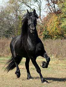
Friesland is mainly an agricultural province. The black and white Frisian cattle, black and white Stabyhoun and the black Frisian horse originated here. Tourism is another important source of income: the principal tourist destinations include the lakes in the southwest of the province and the islands in the Wadden Sea to the north. There are 195 windmills in the province of Friesland, out of a total of about 1200 in the entire country.
Culture
Languages
Friesland is the only one of the twelve provinces of the Netherlands to have its own language that is recognized as such, West Frisian. For over half of the inhabitants of the province of Friesland, 55% (ca. 354,000 people), Frisian is the native language. Most of the other inhabitants are native speakers of Dutch.
West Frisian is also spoken in a small adjacent part of the province of Groningen, to the east. Closely related languages are spoken in nearby areas of Germany. They are East Frisian (Seeltersk, which is different from East Frisian (Ostfriesisch) and is spoken in the Saterland, and a collection of Low German dialects of East Frisia) and North Frisian, spoken in North Friesland. These languages are also closely related to English.
In Stellingwerf, in south-east Friesland, a dialect of Low Saxon is spoken.[11]
Sports

The province is famous for its speed skaters, with mass participation in cross-country ice skating when weather conditions permit. When winters are cold enough to allow the freshwater canals to freeze hard, the province holds its traditional Elfstedentocht (Eleven cities tour), a 200-kilometre (120 mi) ice skating tour. A traditional sport is Frisian handball. Another Frisian practice is fierljeppen, a sport with some similarities to pole vaulting. A jump consists of an intense sprint to the pole (polsstok), jumping and grabbing it, then climbing to the top while trying to control the pole's forward and lateral movements over a body of water and finishing with a graceful landing on a sand bed opposite to the starting point. Because of all the diverse skills required in fierljeppen, fierljeppers are considered to be very complete athletes with superbly developed strength and coordination. In the warmer months, many Frisians practice wadlopen, the traditional art of wading across designated sections of the Wadden Sea at low tide.
There are currently two top level football clubs playing in Friesland: SC Cambuur from Leeuwarden (home stadium Cambuur Stadion) and SC Heerenveen (home stadium Abe Lenstra Stadion).
Politics

The acting King's Commissioner of Friesland is Joan Leemhuis-Stout.[12] The States of Friesland have 43 seats. The Provincial Executive is a coalition of the Christian Democratic Appeal, the People's Party for Freedom and Democracy, the Socialist Party and the Frisian National Party (FNP).
2015 provincial elections[13]
| Party | Votes | Seats | |
|---|---|---|---|
| Labour Party | 40.984 | 7 | |
| Christian Democratic Appeal | 55.017 | 9 | |
| People's Party for Freedom and Democracy | 29.085 | 5 | |
| Frisian National Party | 25.027 | 4 | |
| Party for Freedom | 23.112 | 4 | |
| Socialist Party | 28.930 | 5 | |
| ChristianUnion | 19.669 | 3 | |
| GreenLeft | 9.393 | 1 | |
| Democrats 66 | 18.454 | 3 | |
| 50PLUS | 6.372 | 1 | |
| Party for the Animals | 6.806 | 1 | |
| Total | 297,307 | 43 | |
Transport

The four motorways in the province are A6, A7 (E22), A31, and A32.[15]
The main railway station of Friesland is Leeuwarden, which connects the railways Arnhem–Leeuwarden, Harlingen–Nieuweschans, and Leeuwarden–Stavoren which are all (partially) located in the province.
| Trajectory | Railway stations in Friesland |
|---|---|
| Arnhem–Leeuwarden | Drenthe – Wolvega – Heerenveen IJsstadion – Heerenveen – Akkrum – Grou-Jirnsum – Leeuwarden |
| Harlingen–Nieuweschans | Harlingen Haven – Harlingen – Franeker – Dronrijp – Deinum – Leeuwarden – Leeuwarden Camminghaburen – Hurdegaryp – Veenwouden – Zwaagwesteinde – Buitenpost – Groningen |
| Leeuwarden–Stavoren | Leeuwarden – Mantgum – Sneek Noord – Sneek – IJlst – Workum – Hindeloopen – Koudum-Molkwerum – Stavoren |
Ameland Airport near Ballum[16] and Drachten Airfield near Drachten[17] are the two general aviation airports in the province. The Royal Netherlands Air Force uses Vlieland Heliport and the Leeuwarden Air Base.
Change of name
In 1996 the States of Friesland resolved that the official name of the province should follow the Frisian spelling rather than the Dutch spelling, resulting in "Friesland" being replaced by "Fryslân".[18] In 2004 the Dutch government confirmed this resolution, putting in place a three-year scheme to oversee the name change and associated cultural programme.[19]
The province of Friesland is occasionally referred to as "Frisia" by, amongst others, Hanno Brand, head of the history and literature department at the Fryske Akademy since 2009,[20] however the English-language webpage of the Friesland Provincial Council refers to the province as "Fryslân".[21]
Media
Friesch Dagblad[22] and Leeuwarder Courant[23] are daily newspapers mainly written in Dutch. Omrop Fryslân is the public broadcaster with radio and TV programs mainly in Frisian.[24]
References
- ↑ Harmer, F. E. (1955). "The Anglo-Saxon Missionaries in Germany: being the Lives of S.S. Willibrord, Boniface, Strum, Leoba and Lebuin, together with the Hodoeporicon of St. Willibald and a selection from the Correspondence of St. Boniface. Translated and edited by C. H. Talbot". The Journal of Ecclesiastical History. 6 (2): 230–231.
- ↑ Fryslan.nl (1 December 2009), mun. and CBS
- 1 2 "Bevolkingsontwikkeling; regio per maand" [Population growth; regions per month]. CBS Statline (in Dutch). CBS. 26 June 2014. Retrieved 24 July 2014.
- 1 2 "Kerncijfers wijken en buurten" [Key figures for neighbourhoods]. CBS Statline (in Dutch). CBS. 2 July 2013. Retrieved 12 March 2014.
- ↑ (Dutch) Leeuwarden extremen tijdvak 1971 t/m 2000, Royal Netherlands Meteorological Institute. Retrieved on 26 April 2014.
- ↑ (Dutch) Leeuwarden, langjarige gemiddelden, tijdvak 1981–2010, Royal Netherlands Meteorological Institute. Retrieved on 26 April 2014.
- ↑ (Dutch) Emigration to the United States.
- ↑ (Dutch) Overzicht aantal inwoners Provincie Friesland 1714–2000, Tresoar.
- ↑ (Dutch) Bevolking; geslacht, leeftijd, burgerlijke staat en regio, 1 januari, Statistics Netherlands, 2014.
- ↑ Alighieri, Dante. Divine Comedy, "Inferno", Canto 31, line 64, in The Portable Dante, ed. Paolo Milano, trans. Laurence Binyon, Penguin, 1975 ISBN 0-14-015032-3
- ↑ Hammarström, Harald; Forkel, Robert; Haspelmath, Martin; Bank, Sebastian, eds. (2016). "Stellingwerfs". Glottolog 2.7. Jena: Max Planck Institute for the Science of Human History.
- ↑ "Mevrouw Joan Leemhuis-Stout waarnemend commissaris in Fryslân - Provincie Fryslân". www.fryslan.frl (in Dutch). Retrieved 19 November 2016.
- ↑ (Dutch) Verkiezingsuitslagen Provinciale Staten 1918 – heden, Electoral Council. Retrieved on 27 April 2014.
- ↑ (Dutch) Station Leeuwarden in Leeuwarden, Rijksmonumenten.nl. Retrieved on 26 April 2014.
- ↑ (Dutch) Wegenoverzicht, Rijkswaterstaat. Retrieved on 27 April 2014.
- ↑ (Dutch) Algemene informatie, Ameland Airport. Retrieved on 27 April 2014.
- ↑ (Dutch) Aanwijzingsbesluit Luchthaven Drachten, 2007. Retrieved on 27 April 2014.
- ↑ "Beslut fan Provinsjale Staeten van Friesland" [Resolution of the Provincial Council of Friesland]. Provinciaal Blad van Friesland (in Western Frisian) (7). 28 March 1996.
- ↑ "Ook voor rijk heet Friesland Fryslân" [Friesland to be called Fryslân across the realm]. Leeuwarder Courant (in Dutch). 10 November 2004. Retrieved 11 August 2012.
- ↑ Brand, Hanno (2011). Cole, Jeffrey E., ed. Frisians. Ethnic Groups of Europe: An Encyclopedia. Santa Barbara, California. p. 150. ISBN 978-1-59884-302-6.
- ↑ "provinsje Fryslan, provincie fryslan English". provinsje Fryslan/provincie fryslan. Retrieved 11 August 2012.
- ↑ (Dutch) Missie Friesch Dagblad, Friesch Dagblad. Retrieved on 27 April 2014.
- ↑ (Dutch) Over de LC, Leeuwarder Courant. Retrieved on 27 April 2014.
- ↑ (West Frisian) Oer de Omrop, Omrop Fryslân. Retrieved on 27 April 2014.
External links
| Wikimedia Commons has media related to Friesland. |
| Wikivoyage has a travel guide for Friesland. |
- Province of Fryslân, official government website
- Provincial Tourist Board
- Frisian Film Archive
-
 "Friesland". Encyclopædia Britannica (11th ed.). 1911.
 |
North Sea | | ||
| |
Groningen | |||
| ||||
| | ||||
| North Holland / IJsselmeer | Flevoland | Overijssel / Drenthe |


 | ||
|  | |||||||
| County | ||||||||
| Imperial City | ||||||||
| Dependent territories | ||||||||
1 until 1648; 2 until 1659; 3 until 1678.
Circles est. 1500: Bavarian, Swabian, Upper Rhenish, Lower Rhenish–Westphalian, Franconian, (Lower) Saxon Circles est. 1512: Austrian, Burgundian, Upper Saxon, Electoral Rhenish · Unencircled territories | ||||||||