Frumoasa, Harghita
| Frumoasa Csíkszépvíz | |
|---|---|
| Commune | |
|
View from the reservoir | |
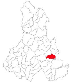 Location of Frumoasa, Harghita | |
 Frumoasa Location of Frumoasa, Harghita | |
| Coordinates: 46°27′0″N 25°51′0″E / 46.45000°N 25.85000°ECoordinates: 46°27′0″N 25°51′0″E / 46.45000°N 25.85000°E | |
| Country |
|
| County | Harghita County |
| Status | Commune |
| Government | |
| • Mayor | Tibor Ferencz[1] (Democratic Union of Hungarians in Romania) |
| Area | |
| • Total | 84.06 km2 (32.46 sq mi) |
| Population (2011[2]) | |
| • Total | 3,633 |
| • Density | 43.44/km2 (112.5/sq mi) |
| Time zone | EET (UTC+2) |
| • Summer (DST) | EEST (UTC+3) |
| Postal Code | 537115 |
| Area code(s) | +40 266 |
| Website | www.csikszepviz.ro |

Frumoasa (Hungarian: Szépvíz or Csíkszépvíz, Hungarian pronunciation: [ˈtʃiːkseːpviːz]) is a commune in Harghita County, Romania. It lies in the Székely Land, an ethno-cultural region in eastern Transylvania.
Component villages
The commune is composed of four villages:
| In Romanian | In Hungarian |
|---|---|
| Bârzava | Csíkborzsova |
| Făgețel | Bükkloka |
| Frumoasa | Csíkszépvíz |
| Nicolești | Csíkszentmiklós |
History

The first written mention of the village is from 1567 as Zepwyz. In 1602 it was recorded as Szépviz ("beautiful water"). Its original Romanian name derived from the Hungarian toponym as Ciuc-Sepviz which was Romanianized to its current official name in 1919.[3]
According to tradition, the village's original name was Szépmező. According to Balázs Orbán, it was founded during the reign of László I as a community of border guards for the defense of the Ghimeṣ pass, on the eastern border of the Kingdom of Hungary. The Roman Catholic chapel was built before 1694 by the Bíró family. The Roman Catholic church was built in 1892.
The village administratively belonged to Csíkszék, then, from 1876 until 1918 to the Csík County in the Kingdom of Hungary. After World War I, by the terms of the Treaty of Trianon of 1920, it became part of Romania. As a result of the Second Vienna Award, it belonged to Hungary again between 1940 and 1944. After World War II, it came under Romanian administration and became part of Romania in 1947. Between 1952 and 1960, it formed part of the Hungarian Autonomous Province; it then formed part of the Mureş-Hungarian Autonomous Province until it was abolished in 1968. Since then, the commune has been part of Harghita County.
Demographics
The commune has an absolute Székely (Hungarian) majority. According to the 2002 census it has a population of 3,652; of which 96.39% or 3,520 are Hungarian.[4]
The village of Făgăţel has a significant population of ethnic Romanians, numbering 64 of the village's 130 inhabitants.
Tourist attractions
- Saint Gregory the Illuminator Armenian Church
- 'Snowy' Virgin Mary Catholic Parish Church
- Ruins of the St. Ladislaus Gothic chapel on Pagan Mountain
- Biró-Chapel (Craftsmen's Chapel)
- Ski track
Twinnings
Picture gallery
-

As "Szép Víz" on 18th century map (Josephine Land Survey)
-

The reservoir
-
.jpg)
The reservoir
-

View of Făgeţel (Bükkloka)
-

Saint Ladislaus Church
References
- ↑ (Romanian) alegeri.tv - Alegeri locale 2012 - Rezultate alegeri Primăria Frumoasa, judeţul Harghita; retrieved on March 26, 2013
- ↑ (Romanian) harghita.insse.ro - Recensământul populaţiei şi al locuinţeloe 2011, judeţul Harghita (date ptrovizorii); retrieved on March 26, 2013
- ↑ János András Vistai. "Tekintő – Erdélyi Helynévkönyv". Transylvanian Toponym Book
- ↑ "Etnikai statisztikák" (in Hungarian). Árpád E. Varga. Retrieved 12 May 2010.

Localities which belonged to the First Székely Infantry Regiment from 1762 till 1851 | ||
|---|---|---|
| 1st Company |
|  |
| 2nd Company |
| |
| 3rd Company |
| |
| 4th Company |
| |
| 5th Company |
| |
| 6th Company |
| |
| 7th Company | ||
| 8th Company |
| |
| 9th Company | ||
| 10th Company |
| |
| 11th Company | ||
| 12th Company | ||