Forks of Waters, Virginia
| Forks of Waters | |
|---|---|
| Unincorporated community | |
|
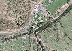
Aerial view of Forks of Waters. The South Branch Potomac River flows diagonally across the image. | |
 Forks of Waters  Forks of Waters Location within the Commonwealth of Virginia | |
| Coordinates: 38°28′56″N 79°30′31″W / 38.48222°N 79.50861°WCoordinates: 38°28′56″N 79°30′31″W / 38.48222°N 79.50861°W | |
| Country | United States |
| State | Virginia |
| County | Highland |
| Elevation | 2,313 ft (705 m) |
| Time zone | Eastern (EST) (UTC-5) |
| • Summer (DST) | EDT (UTC-4) |
| ZIP codes | 24465 |
| GNIS feature ID | 1483492[1] |
_near_Forks_of_Waters_in_Highland_County%2C_Virginia.jpg)
View north along US 220 in Forks of Waters
Forks of Waters (formerly Strait Creek) is an unincorporated community located in Highland County, Virginia, United States.[1] Forks of Waters is located approximately 6 miles (9.7 km) northeast of Monterey, Virginia at the junction of U.S. Route 220 and Virginia State Route 642.[2][3] Forks of Waters is so named due to the convergence of the Strait Creek with the South Branch Potomac River near the community.[2][4] After passing through Forks of Waters, the South Branch Potomac River enters West Virginia approximately 1 mile (1.6 km) to the northeast.[4]
References
- 1 2 "Forks of Waters". Geographic Names Information System. United States Geological Survey. Retrieved December 23, 2013.
- 1 2 "Domestic Geographic Name Report Form - Forks of Waters, Virginia". U.S. Department of the Interior Board on Geographic Names. Retrieved December 23, 2013.
- ↑ Google (December 23, 2013). "Forks of Waters, Virginia" (Map). Google Maps. Google. Retrieved December 23, 2013.
- 1 2 Morton, Oren Frederic (1911). A History of Highland County, Virginia. p. 13.
Municipalities and communities of Highland County, Virginia, United States | ||
|---|---|---|
| Town |  | |
| Unincorporated communities | ||
| Footnotes | ‡This populated place also has portions in an adjacent county or counties | |
This article is issued from Wikipedia - version of the 11/2/2016. The text is available under the Creative Commons Attribution/Share Alike but additional terms may apply for the media files.