Flag Fen
 Location within Cambridgeshire | |
| Coordinates | 52°34′26″N 0°11′24″W / 52.574°N 0.190°W |
|---|---|
| Type | Archaeological open-air museum |
| Website | Flag Fen |
Flag Fen, east of Peterborough,[1] England, is a Bronze Age site developed about 3500 years ago, comprising over 60,000 timbers, arranged in five very long rows,[2] creating a wooden causeway (around 1 km long) across the wet fenland. Part way across the structure, a small island was formed. Items associated with it have led scholars to conclude the island was a site of religious ceremonies and significance. Archaeological work began in 1982 at the site, which is located 800 m (0.5 miles) east of Fengate.[3][4] Some areas have been reconstructed, including a typical Iron Age roundhouse dwelling.
Flag Fen is part of the Greater Fens Museum Partnership. A visitor centre has been constructed on site.
Construction
A Neolithic trackway once ran across what archaeologists have termed as the "Flag Fen Basin", from a dry-land area known as Fengate,[4] to a natural clay island called Northey[1] (now the site of Whittlesey).[5] The basin is an embayment of low-lying land on the western margins of the Fens.[1] The level of inundation by 1300 BC led the occupants to construct a timber causeway along the trackway route.[5]
The causeway, and centre platform, were formed by driving 'thousands of posts with long pencil-like tips' through the 'accumulating peaty muds' and into the firmer ground below.[5] The resulting structure covered three and a half acres.[6] Dendrochronological analysis, or dating of the posts by studying tree rings, led to an estimated date for the various stages of construction as between 1365 and 967 BC.[2]
Some of the timbers, such as oak, were not natural to the local environment.[2] This means that the people who constructed this timber causeway wanted to use materials that perhaps had religious significance to their lives. They made a significant effort to transport the timbers to the site from distant sources.[2] Similarly, scholars have traced the bluestone used at Stonehenge, Salisbury, as originating in the Preseli Mountains in Wales.
Purpose

Many items denoting 'rank and prestige' were deposited in the water surrounding Flag Fen,[7] including swords, spearheads, 'gold earrings, tiny pins and brooches'.[5] Archaeologist Francis Pryor, who discovered the site in 1982, suggests that 'settlers often vied for social status by showing they could afford to discard valuable possessions'.[6] There is also evidence of intentional destruction before placement, e.g., daggers broken in half placed on top of each other.[8]
Other finds included small, polished, white stones of a type not known in the area, indicating that they had been intentionally collected, transported to, and placed at the site.[2] Significance is also drawn from the discovery of the ritual deposits within thirty metres of the timber post line, and only on its southern boundary.[9]
The amount, type, and placement of deposits, which continued for over 1,200 years,[10] supports the theory that 'at least one facet of the site' was a role as a 'religious monument'.[7]
Other artefacts that were found comprised animal bones. Of these, horse mandibles were found. Horses were very valuable to the prehistoric people, as they provided a means of transport, and could supplement or replace man-power. They could be used to carry or pull timbers on sledges, for example, over long distances.
On Northey Island, many round barrows, contemporary with Flag Fen, were found. These seemed to be constructed over the dwellings of 'chiefs'. Mike Parker Pearson refers to this as the "Land of the Dead." There is also evidence of farming, including sheep remains, contemporary with the site. Phosphate analysis reveals high concentrations of cremations in the barrows, in the form of satellite and secondary burials in the round barrows. This suggests that the primary burials may have been of chiefs, or socially powerful/respected people, and that some people may have paid to be buried close to the person they respected or followed.
Destruction and preservation
Archaeologists believe that the community was destroyed by a fire at the end of the Bronze Age, which damaged the posts that held the homes above the waterlogged earth, causing the dwellings to collapse into the river and forcing the inhabitants to hastily flee. The effects of the fire then carbonized the remains of the collapsed buildings, helping to preserve them.[11]
From there, the anaerobic conditions generated by deposited silt from the fens protected the wood, posts, and rafters of the collapsed structures from rotting away under the influence of air and bacteria.[11][12] In the 10th century BC, the ground level was much lower than today, increasing around 1 mm (0.039 inches) per year as autumnal debris was added to the surface of the fens. By the early Roman period, most of the structure was covered and preserved.[12]
Because of its waterlogged condition, the Flag Fen Basin was an area where peat deposits developed around 2000 BCE, which survive there today.[1]
Archaeological investigation
The site was first discovered in 1982 when a team led by Francis Pryor carried out a survey of dykes in the area funded by English Heritage.[4] Pryor told National Geographic, in 1992, that he "stumbled – literally – upon' Flag Fen 'when he tripped on a piece of wood lying in the bottom of a drainage ditch."[6]
Excavation commenced in the summer of 1984 and, by 1990, had revealed vertical and horizontal timbers, animal bones, a bronze dagger and other metal items and fragments, flint implements and 400 potsherds.[4] Further finds included items imported from continental Europe and the oldest surviving wooden wheel found in England.[13]
In 2012 DigVentures ran the world’s first crowdfunded excavation, raising £30,000 to enable a three-week excavation at Flag Fen. The site had experienced a 50% decline in visitors since the large-scale English Heritage-funded excavations finished in 1995; the project’s remit was to help revitalise the heritage attraction, whilst providing detailed scientific information on the preservation of the waterlogged timbers. The project involved around 250 members of the public from 11 countries, supported by a specialist team including partners from the British Museum, Durham University, Birmingham University, York Archaeological Trust, University College London and English Heritage to assist in the scientific investigations. Of the members of public, 130 individuals received hands-on training in archaeological techniques on site and visitor numbers increased by 29% from the previous year. Francis Pryor was supportive of the initiative and wrote afterwards: "happily, it was an experiment that worked: the participants had a good time, and the archaeology was professionally excavated, to a very high standard."[14]
Preservation
Extensive drainage of the surrounding area, which benefits agriculture, means that many of the timbers are drying out and are threatened with destruction by such exposure.[5] One section of poles is being preserved by replacing the cellulose in the wood with water-carried wax, impregnating the wood over the years. This technique is also being used to preserve Seahenge. Another preservation technique used for timbers found at the site is freeze drying.[2]
Archaeological work at Flag Fen is ongoing.[5] A well-organised visitor centre has been constructed there with a museum and exhibitions.[2]
In the visitor centre's preservation hall, one section of the timbers is preserved in situ and prevented from drying out by misting with water. Also at the site are reconstructions of two Bronze Age roundhouses and one from the Iron Age.[2] A section of the Roman road known as the Fen Causeway has been exposed; it crosses the site. In addition, there is a reconstruction of a prehistoric droveway used for moving livestock from one location to another.
Related books
In 1991 Pryor published his first book about Flag Fen, entitled Flag Fen: Prehistoric Fenland Centre, as one of a series co-produced by English Heritage and B.T. Batsford. The final monograph on the site – entitled The Flag Fen Basin: Archaeology and environment of a Fenland Landscape – was published in 2001 as an English Heritage Archaeological Report. The report is now available online through the Archaeology Data Service.[15]
Pryor has followed this with a third book on the site, published by Tempus in 2005. Entitled Flag Fen: Life and Death of a Prehistoric Landscape, it is what he has described as a "major revision" of his 1991 work, for instance repudiating his earlier "lake village" concept.[16]
Must Farm
Around 2 km south of Flag Fen is Must Farm Bronze Age settlement. Log boats recovered there are preserved and displayed at Flag Fen.[17]
Wildlife
Flag Fen is also home to an abundance of wildlife due to the variety of habitats on site. This includes extensive grassland, traditionally managed hedgerows and woodland and a freshwater mere and dyke.
'Bronze Age' BioBlitz
On 2 August 2014, a BioBlitz organised by Vivacity found 190 species, including 53 lichens and the endangered European water vole and barn owl.[18] The event also included a talk by the People's Trust for Endangered Species and used a wildlife trail to highlight species that would have been present 3000 years ago, such as the grey wolf, brown bear and Eurasian beaver.[19]
Meadow proposals
In 2014, Buglife were successful in a bid to create wildflower meadows across Peterborough, which will include a traditionally managed hay meadow at Flag Fen.[20]
Images
 The visitor centre entrance
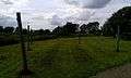 Wooden posts marking the position of the Bronze Age trackway
 The reconstructed Bronze Age roundhouse at Flag Fen
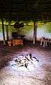 The interior of the reconstructed Bronze Age roundhouse
 The reconstructed Iron Age roundhouse at Flag Fen
 The reconstructed Iron Age roundhouse at Flag Fen
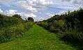 The reconstructed Bronze-Iron Age droveway at Flag Fen
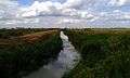 The 14th-century Mustdyke constructed across the site, which bisects the Bronze Age trackway
 The Roman road running through Flag Fen
See also
References
- 1 2 3 4 Pryor 2005. p. 9.
- 1 2 3 4 5 6 7 8 Alan Butler (2011). How to Read Prehistoric Monuments: A Unique Guide to Our Ancient Heritage. Duncan Baird Publishers. pp. 180–181. ISBN 978-1-78028-330-2.
- ↑ Pryor 2005. p. 13.
- 1 2 3 4 Taylor, Maisie; Francis Pryor (February 1990). "Bronze Age Building Techniques at Flag Fen, Peterborough, England". World Archaeology. 21 (3): 425–434. doi:10.1080/00438243.1990.9980117. JSTOR 124839.
- 1 2 3 4 5 6 Francis Pryor (3 June 2010). The Making of the British Landscape: How We Have Transformed the Land, from Prehistory to Today. Penguin Books Limited. pp. 98–99. ISBN 978-0-14-194336-7.
- 1 2 3 "Bronze Age Way of Life Emerges in the Fens". National Geographic Magazine. National Geographic Virtual Library. January 1992.
- 1 2 S. M. Haslam; John William Purseglove; Gerald A. Wait (13 April 1997). The River Scene: Ecology and Cultural Heritage. Cambridge University Press. p. 299. ISBN 978-0-521-57410-5.
- ↑ Fagan, Brian (March–April 1995). "Timelines: New Finds At Flag Fen". Archaeology. 48 (2): 24–26. JSTOR 41771096.
- ↑ Chris Gosden; Jon G. Hather (14 January 2004). The Prehistory of Food: Appetites for Change. Routledge. p. 205. ISBN 978-0-203-20338-5.
- ↑ Richard Bradley (15 April 2013). An Archaeology of Natural Places. Routledge. p. 51. ISBN 978-1-135-95282-2.
- 1 2 Knapton, Sarah (January 12, 2016). "Bronze Age settlement dubbed 'Peterborough Pompeii' due to amazing preservation". The Telegraph. Retrieved 24 January 2016.
- 1 2 Historic England. "A Bronze Age post alignment and timber platform at Flag Fen and associated Bronze Age and later field systems and settlement to either side of the Northey Road. (1406460)". National Heritage List for England.
- ↑ T. Douglas Price (28 February 2013). Europe Before Rome: A Site-by-Site Tour of the Stone, Bronze, and Iron Ages. Oxford University Press. pp. 278–281. ISBN 978-0-19-991470-8.
- ↑ Pryor, Francis. "Flag Fen, 30 years on", 'In The Long Run', 14 November 2012. Retrieved on 19 March 2015.
- ↑ "English Heritage Archaeological Monographs". Archaeology Data Service.
- ↑ Pryor 2005. p. 7.
- ↑ "Discover the Must Farm boats at Vivacity". Retrieved 13 January 2016.
- ↑ "The results are in! BioBlitz reveals a wealth of wildlife at Flag Fen". 23 September 2014. Retrieved 23 September 2014.
- ↑ "Bronze Age BioBlitz".
- ↑ "Peterborough's Buzzing". 23 September 2014. Retrieved 20 October 2014.
Bibliography
- Pryor, Francis (2005). Flag Fen: The Life and Death of a Prehistoric Landscape. Stroud: Tempus. ISBN 978-0752429007.
External links
![]() Media related to Flag Fen at Wikimedia Commons
Media related to Flag Fen at Wikimedia Commons
- Flag Fen Bronze Age Centre and Archaeology Park
- Fenland Archaeological Trust registered charity no. 295116
- Peterborough Museum